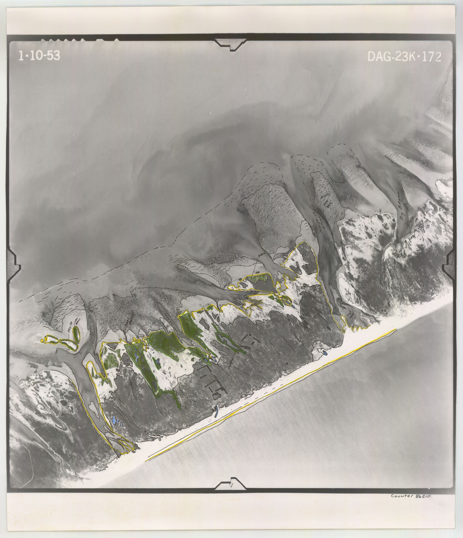
Flight Mission No. DAG-23K, Frame 172, Matagorda County
DAG-23K-172
-
Map/Doc
86510
-
Collection
General Map Collection
-
Object Dates
1953/1/10 (Creation Date)
-
People and Organizations
U. S. Department of Agriculture (Publisher)
-
Counties
Matagorda
-
Subjects
Aerial Photograph
-
Height x Width
18.6 x 16.0 inches
47.2 x 40.6 cm
-
Comments
Flown by Aero Exploration Company of Tulsa, Oklahoma.
Part of: General Map Collection
Harris County State Real Property Sketch 3

Print $42.00
- Digital $50.00
Harris County State Real Property Sketch 3
2004
Size 24.9 x 36.9 inches
Map/Doc 81952
Ector County Working Sketch 28

Print $40.00
- Digital $50.00
Ector County Working Sketch 28
1971
Size 43.3 x 61.6 inches
Map/Doc 68871

Flight Mission No. CUG-3P, Frame 142, Kleberg County

Print $20.00
- Digital $50.00
Flight Mission No. CUG-3P, Frame 142, Kleberg County
1956
Size 18.7 x 22.3 inches
Map/Doc 86277
Flight Mission No. CRK-3P, Frame 127, Refugio County

Print $20.00
- Digital $50.00
Flight Mission No. CRK-3P, Frame 127, Refugio County
1956
Size 18.6 x 22.3 inches
Map/Doc 86915
Map of Nacogdoches County

Print $20.00
- Digital $50.00
Map of Nacogdoches County
1846
Size 44.7 x 40.0 inches
Map/Doc 87355
Hutchinson County Working Sketch 21

Print $20.00
- Digital $50.00
Hutchinson County Working Sketch 21
1965
Size 35.0 x 40.8 inches
Map/Doc 66381
In the Supreme Court of the United States The State of Oklahoma, Complainant vs. The State of Texas, Defendant, The United States of America, Intervener - 1920

Print $20.00
- Digital $50.00
In the Supreme Court of the United States The State of Oklahoma, Complainant vs. The State of Texas, Defendant, The United States of America, Intervener - 1920
1920
Size 39.4 x 35.7 inches
Map/Doc 75264
Val Verde County Sketch File 8

Print $38.00
- Digital $50.00
Val Verde County Sketch File 8
1885
Size 22.6 x 23.2 inches
Map/Doc 12564
Real County Working Sketch 49

Print $20.00
- Digital $50.00
Real County Working Sketch 49
1957
Size 25.9 x 25.7 inches
Map/Doc 71941
Rockwall County Sketch File 2

Print $6.00
Rockwall County Sketch File 2
Size 17.3 x 11.2 inches
Map/Doc 35415
Andrews County Working Sketch 13

Print $20.00
- Digital $50.00
Andrews County Working Sketch 13
1956
Size 37.3 x 30.6 inches
Map/Doc 67059
You may also like
Hall County Rolled Sketch 6

Print $20.00
- Digital $50.00
Hall County Rolled Sketch 6
Size 24.9 x 41.2 inches
Map/Doc 6050
Jefferson Co.

Print $40.00
- Digital $50.00
Jefferson Co.
1978
Size 49.3 x 43.5 inches
Map/Doc 95546
PSL Field Notes for Blocks 77, B2, B3, and A56 in Winkler County

PSL Field Notes for Blocks 77, B2, B3, and A56 in Winkler County
Map/Doc 81679
Dickens County Sketch File 16

Print $4.00
- Digital $50.00
Dickens County Sketch File 16
Size 7.4 x 11.1 inches
Map/Doc 20975
Dickens County Sketch File 4

Print $20.00
- Digital $50.00
Dickens County Sketch File 4
Size 21.2 x 27.1 inches
Map/Doc 11317
Topographical Map of the Rio Grande, Sheet No. 18

Print $20.00
- Digital $50.00
Topographical Map of the Rio Grande, Sheet No. 18
1912
Map/Doc 89542
Original Town of Nadine, Lea County, New Mexico

Print $20.00
- Digital $50.00
Original Town of Nadine, Lea County, New Mexico
Size 27.1 x 33.5 inches
Map/Doc 92420
Terrell County Working Sketch 70

Print $20.00
- Digital $50.00
Terrell County Working Sketch 70
1979
Size 39.0 x 36.5 inches
Map/Doc 69591
Motley County Sketch File 24 (S)

Print $4.00
- Digital $50.00
Motley County Sketch File 24 (S)
Size 9.2 x 7.1 inches
Map/Doc 32204
McMullen County Sketch File 44

Print $6.00
- Digital $50.00
McMullen County Sketch File 44
1942
Size 14.2 x 8.8 inches
Map/Doc 31426
San Patricio County Working Sketch Graphic Index

Print $20.00
- Digital $50.00
San Patricio County Working Sketch Graphic Index
1939
Size 36.6 x 47.9 inches
Map/Doc 76692
Flight Mission No. DQN-5K, Frame 146, Calhoun County

Print $20.00
- Digital $50.00
Flight Mission No. DQN-5K, Frame 146, Calhoun County
1953
Size 18.6 x 22.2 inches
Map/Doc 84421