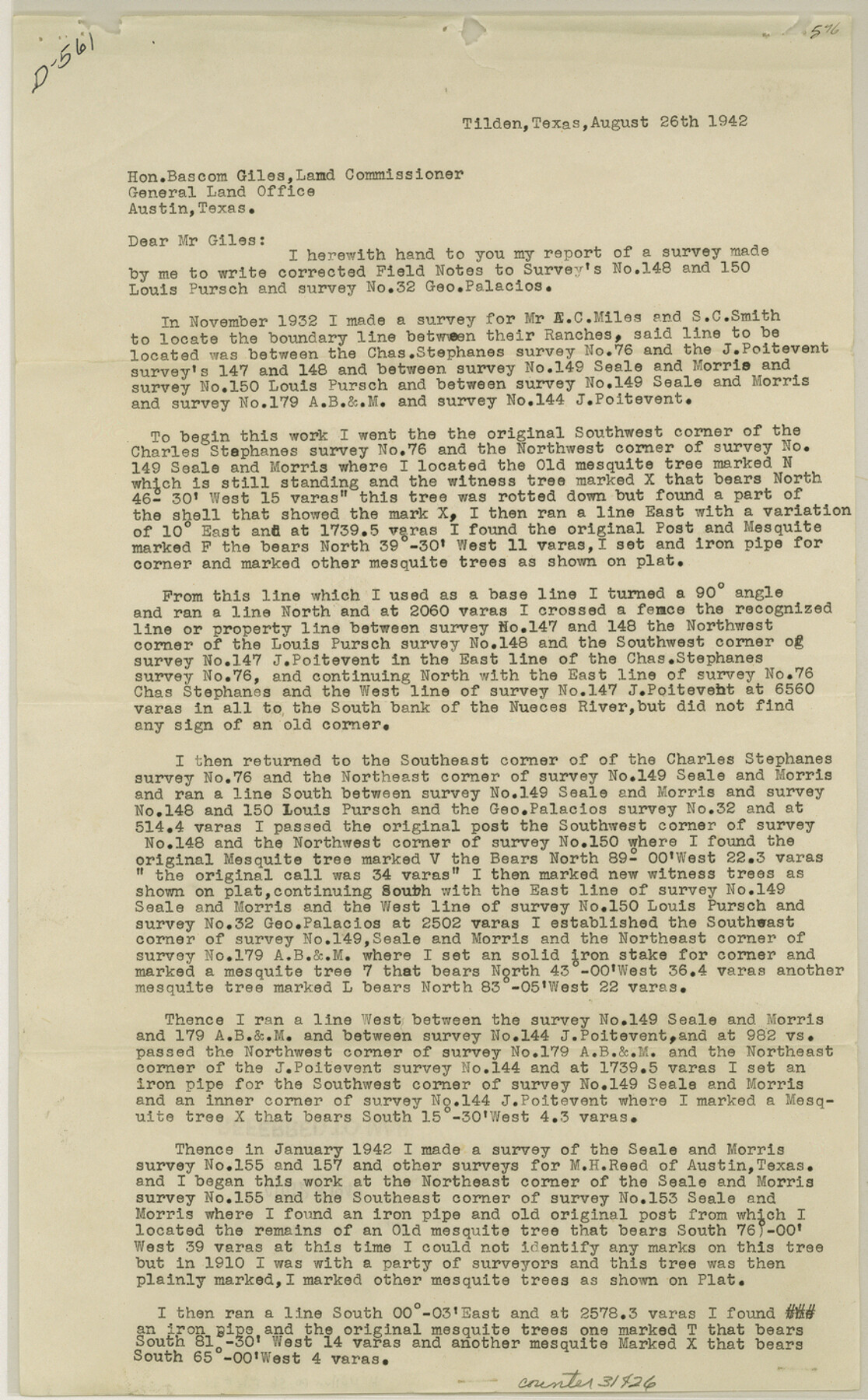
McMullen County Sketch File 44
[Report of survey made to write corrected field notes to surveys 148 and 150, Louis Pursch and survey 32, George Palacios]
-
Map/Doc
31426
-
Collection
General Map Collection
-
Object Dates
1942/8/26 (Creation Date)
1942/9/16 (File Date)
1942/8/26 (Correspondence Date)
1932 (Survey Date)
1926 (Survey Date)
1942 (Survey Date)
-
People and Organizations
W.S. Goff (Surveyor/Engineer)
Roy Fenner (Surveyor/Engineer)
-
Counties
McMullen Bee
-
Subjects
Surveying Sketch File
-
Height x Width
14.2 x 8.8 inches
36.1 x 22.4 cm
-
Medium
paper, print
-
Features
Nueces River
Elm Creek
S.C. Smith Ranch
Part of: General Map Collection
El Paso County Sketch File 39

Print $27.00
- Digital $50.00
El Paso County Sketch File 39
1922
Size 13.9 x 8.8 inches
Map/Doc 22225
Cameron County Rolled Sketch 19

Print $2.00
- Digital $50.00
Cameron County Rolled Sketch 19
Size 7.0 x 5.6 inches
Map/Doc 5467
Williamson County Sketch File 16

Print $20.00
- Digital $50.00
Williamson County Sketch File 16
Size 16.8 x 25.5 inches
Map/Doc 12693
Jasper County Working Sketch 22

Print $20.00
- Digital $50.00
Jasper County Working Sketch 22
1943
Size 21.0 x 15.4 inches
Map/Doc 66484
Pecos County Sketch File 106a

Print $4.00
- Digital $50.00
Pecos County Sketch File 106a
1968
Size 11.3 x 8.5 inches
Map/Doc 34033
Map of the Lands Surveyed by the Memphis, El Paso & Pacific R.R. Company

Print $20.00
- Digital $50.00
Map of the Lands Surveyed by the Memphis, El Paso & Pacific R.R. Company
1859
Size 11.4 x 18.6 inches
Map/Doc 4850
Flight Mission No. CUG-3P, Frame 23, Kleberg County

Print $20.00
- Digital $50.00
Flight Mission No. CUG-3P, Frame 23, Kleberg County
1956
Size 18.5 x 22.3 inches
Map/Doc 86233
Nueces County Rolled Sketch 10

Print $40.00
- Digital $50.00
Nueces County Rolled Sketch 10
Size 31.6 x 55.4 inches
Map/Doc 8350
Rains County Working Sketch 6

Print $20.00
- Digital $50.00
Rains County Working Sketch 6
1958
Size 26.4 x 42.3 inches
Map/Doc 71832
Oldham County Sketch File 10

Print $8.00
- Digital $50.00
Oldham County Sketch File 10
Size 12.7 x 8.3 inches
Map/Doc 33243
Index for Texas Railroad ROW & track maps available on microfilm at THD & Archives and Records

Print $2.00
- Digital $50.00
Index for Texas Railroad ROW & track maps available on microfilm at THD & Archives and Records
1977
Size 11.3 x 8.6 inches
Map/Doc 60761
Sabine County Sketch File 7

Print $2.00
Sabine County Sketch File 7
1882
Size 8.6 x 12.7 inches
Map/Doc 35619
You may also like
Refugio County Working Sketch 2

Print $20.00
- Digital $50.00
Refugio County Working Sketch 2
1927
Size 17.6 x 19.4 inches
Map/Doc 63511
Martin County Working Sketch 11

Print $40.00
- Digital $50.00
Martin County Working Sketch 11
1971
Size 49.8 x 38.1 inches
Map/Doc 70829
Hartley County Sketch File 4

Print $6.00
- Digital $50.00
Hartley County Sketch File 4
1883
Size 10.6 x 8.1 inches
Map/Doc 26087
[T. & G. Ry. Main Line, Texas, Right of Way Map, Center to Gary]
![64569, [T. & G. Ry. Main Line, Texas, Right of Way Map, Center to Gary], General Map Collection](https://historictexasmaps.com/wmedia_w700/maps/64569.tif.jpg)
Print $40.00
- Digital $50.00
[T. & G. Ry. Main Line, Texas, Right of Way Map, Center to Gary]
1917
Size 31.5 x 76.7 inches
Map/Doc 64569
Hill County Sketch File 10

Print $4.00
- Digital $50.00
Hill County Sketch File 10
1859
Size 7.1 x 8.2 inches
Map/Doc 26478
Sterling County Working Sketch Graphic Index

Print $20.00
- Digital $50.00
Sterling County Working Sketch Graphic Index
1971
Size 45.5 x 36.3 inches
Map/Doc 76703
Foard County Sketch File 30

Print $6.00
- Digital $50.00
Foard County Sketch File 30
Size 9.1 x 8.2 inches
Map/Doc 22858
[Bastrop District]
![83005, [Bastrop District], General Map Collection](https://historictexasmaps.com/wmedia_w700/maps/83005.tif.jpg)
Print $40.00
- Digital $50.00
[Bastrop District]
1895
Size 37.4 x 51.9 inches
Map/Doc 83005
Geological Report on Robertson County

Print $20.00
- Digital $50.00
Geological Report on Robertson County
1918
Size 21.7 x 25.8 inches
Map/Doc 97084
Harris County State Real Property Sketch 1

Print $40.00
- Digital $50.00
Harris County State Real Property Sketch 1
1985
Size 42.7 x 41.6 inches
Map/Doc 61690
Lynn County Sketch File 21

Print $52.00
- Digital $50.00
Lynn County Sketch File 21
1913
Size 5.7 x 8.6 inches
Map/Doc 30528
Houston County Working Sketch 11

Print $20.00
- Digital $50.00
Houston County Working Sketch 11
1953
Size 28.5 x 24.5 inches
Map/Doc 66241