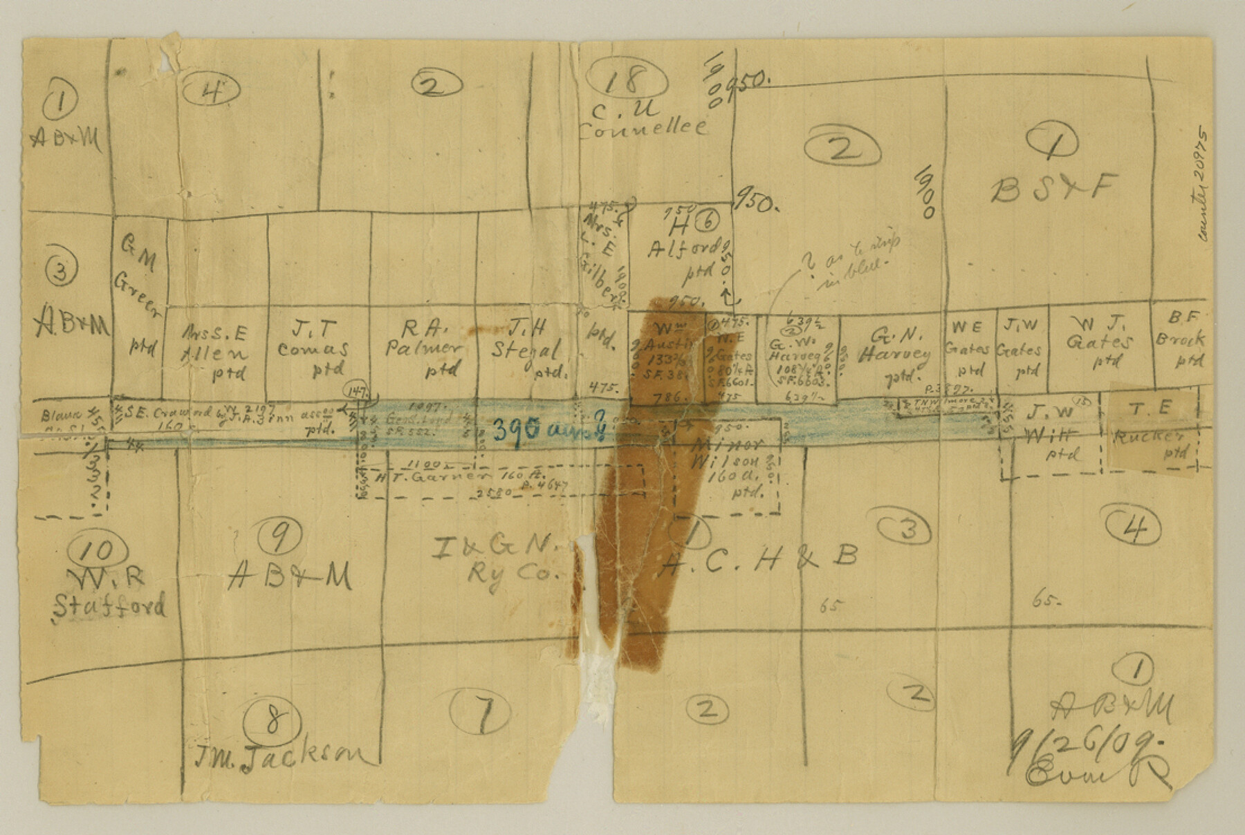
Dickens County Sketch File 16
[Office sketch showing G. W. Harvey survey and vacancy south]
-
Map/Doc
20975
-
Collection
General Map Collection
-
Object Dates
1909/9/26 (File Date)
Cr/9126/1909
-
People and Organizations
E. von Rosenberg (Draftsman)
G.W. Harvey (Surveyor/Engineer)
-
Counties
Dickens
-
Subjects
Surveying Sketch File
-
Height x Width
7.4 x 11.1 inches
18.8 x 28.2 cm
-
Medium
paper, manuscript
Part of: General Map Collection
Red River County Sketch File 1a

Print $4.00
- Digital $50.00
Red River County Sketch File 1a
1854
Size 12.7 x 8.0 inches
Map/Doc 35093
East Portion of Matagorda Bay in Matagorda County, showing Subdivision for Mineral Development

Print $40.00
- Digital $50.00
East Portion of Matagorda Bay in Matagorda County, showing Subdivision for Mineral Development
1949
Size 30.8 x 51.1 inches
Map/Doc 1909
Harris County Working Sketch 8

Print $20.00
- Digital $50.00
Harris County Working Sketch 8
1904
Size 26.8 x 23.3 inches
Map/Doc 65900
Amistad International Reservoir on Rio Grande 108

Print $20.00
- Digital $50.00
Amistad International Reservoir on Rio Grande 108
1950
Size 28.5 x 40.9 inches
Map/Doc 75539
Flight Mission No. BQY-4M, Frame 116, Harris County

Print $20.00
- Digital $50.00
Flight Mission No. BQY-4M, Frame 116, Harris County
1953
Size 18.5 x 22.4 inches
Map/Doc 85283
Etats-Unis de l'Amérique Septentrionale avec les Isles Royale, de Terre Neuve de St. Jean, L'Acadie &c.

Print $20.00
- Digital $50.00
Etats-Unis de l'Amérique Septentrionale avec les Isles Royale, de Terre Neuve de St. Jean, L'Acadie &c.
1785
Size 20.9 x 28.2 inches
Map/Doc 93679
Aransas County Rolled Sketch 10

Print $58.00
- Digital $50.00
Aransas County Rolled Sketch 10
1936
Size 10.6 x 15.4 inches
Map/Doc 42208
Anderson County Sketch File 29

Print $4.00
- Digital $50.00
Anderson County Sketch File 29
1873
Size 10.4 x 8.2 inches
Map/Doc 12814
Roberts County Working Sketch 15

Print $20.00
- Digital $50.00
Roberts County Working Sketch 15
1975
Size 40.5 x 38.7 inches
Map/Doc 63541
Brown County State Real Property Sketch 1

Print $80.00
- Digital $50.00
Brown County State Real Property Sketch 1
2018
Size 48.0 x 36.0 inches
Map/Doc 95204
Culberson County Rolled Sketch 32
Print $20.00
- Digital $50.00
Culberson County Rolled Sketch 32
1931
Size 20.2 x 36.4 inches
Map/Doc 5657
Val Verde County Rolled Sketch 33

Print $20.00
- Digital $50.00
Val Verde County Rolled Sketch 33
1891
Size 27.8 x 28.2 inches
Map/Doc 8112
You may also like
Flight Mission No. BRA-16M, Frame 124, Jefferson County

Print $20.00
- Digital $50.00
Flight Mission No. BRA-16M, Frame 124, Jefferson County
1953
Size 18.7 x 22.5 inches
Map/Doc 85734
Map of the Texas & Pacific Railway and connections

Print $20.00
- Digital $50.00
Map of the Texas & Pacific Railway and connections
1899
Size 17.9 x 36.6 inches
Map/Doc 95765

Newton County Working Sketch 27

Print $20.00
- Digital $50.00
Newton County Working Sketch 27
1953
Size 25.9 x 30.0 inches
Map/Doc 71273
Wise County Working Sketch 22

Print $20.00
- Digital $50.00
Wise County Working Sketch 22
1980
Size 28.1 x 27.8 inches
Map/Doc 72636
Williamson County

Print $40.00
- Digital $50.00
Williamson County
1946
Size 38.7 x 56.8 inches
Map/Doc 95676
Sutton County Working Sketch 26

Print $20.00
- Digital $50.00
Sutton County Working Sketch 26
Size 24.0 x 24.7 inches
Map/Doc 62369

Trinity River, Post Oak Creek Sheet

Print $4.00
- Digital $50.00
Trinity River, Post Oak Creek Sheet
1930
Size 20.6 x 23.0 inches
Map/Doc 65227
Nueces County Rolled Sketch 48

Print $20.00
- Digital $50.00
Nueces County Rolled Sketch 48
1957
Size 33.1 x 45.1 inches
Map/Doc 6887
[Jones County School Land, Blocks P, D, D6, and CB]
![91091, [Jones County School Land, Blocks P, D, D6, and CB], Twichell Survey Records](https://historictexasmaps.com/wmedia_w700/maps/91091-1.tif.jpg)
Print $2.00
- Digital $50.00
[Jones County School Land, Blocks P, D, D6, and CB]
1907
Size 8.0 x 14.5 inches
Map/Doc 91091
Concho County Rolled Sketch 1

Print $20.00
- Digital $50.00
Concho County Rolled Sketch 1
1945
Size 19.5 x 25.0 inches
Map/Doc 5543