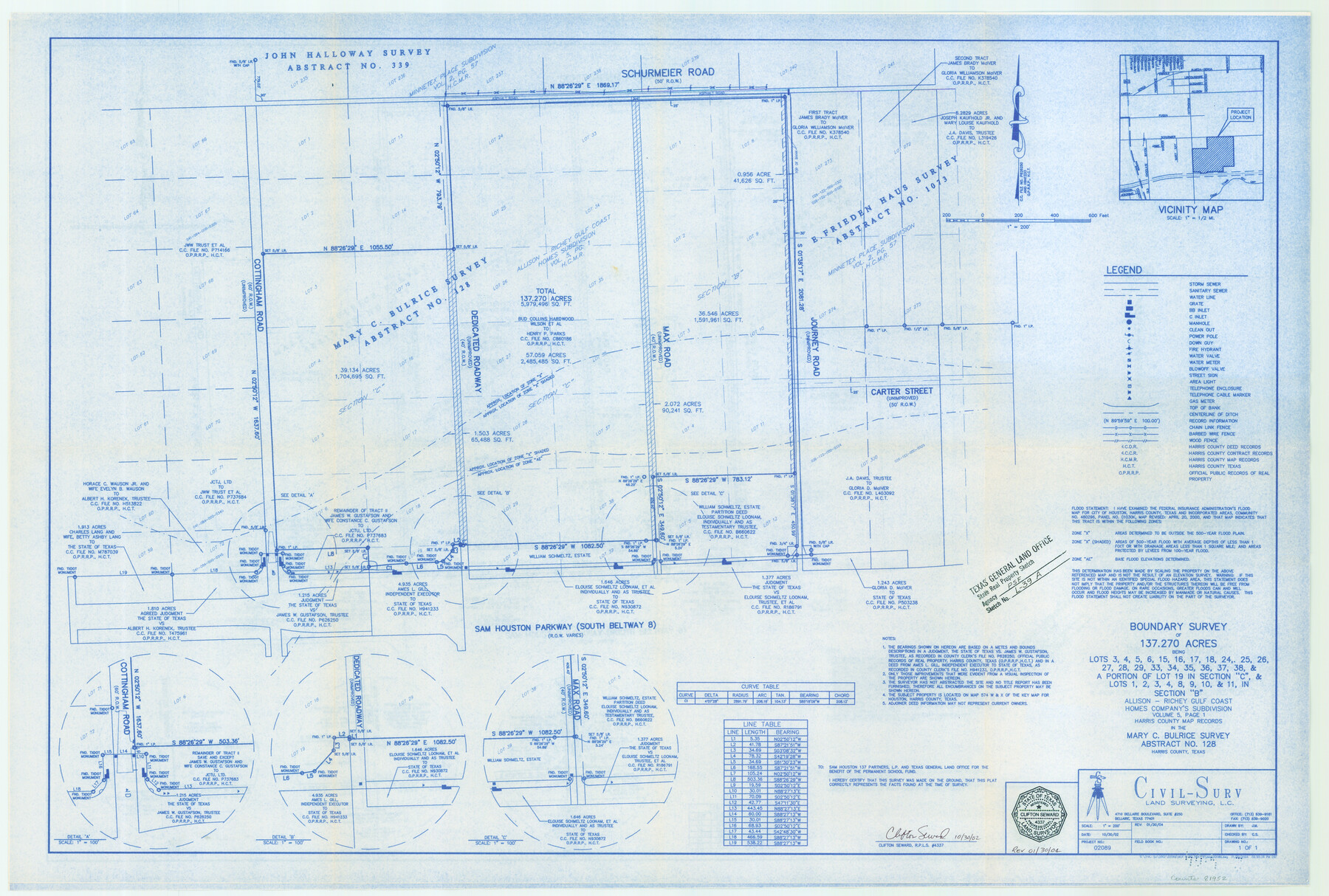
Harris County State Real Property Sketch 3
A Boundary Survey of 137.270 Acres and 10.9825 Acres in the Mary C. Bulrice Survey, A - 128 and E. Friedenhaus, A - 1073
State Real Property Sketch L - 39
- 
                          Map/Doc
81952
 - 
                            Collection
General Map Collection
 - 
                            Object Dates
2004/1/30 (Creation Date)
2004/6/17 (File Date)
 - 
                            People and Organizations
Civil-Surv Land Surveying, L.C. (Publisher)
Civil-Surv Land Surveying, L.C. (Printer)
J.M. (Draftsman)
Clifton Seward (Surveyor/Engineer)
 - 
                            Counties
Harris
 - 
                            Subjects
State Real Property
 - 
                            Height x Width
24.9 x 36.9 inches
63.2 x 93.7 cm
 - 
                            Comments
Surveys located about 11 miles South 10 degrees East of Houston, Texas.
See, also, School Files 155129 and 155219. 
Part of: General Map Collection
            Shackelford County Boundary File 3


                                            Print $42.00                    
                                             -                         Digital $50.00                                    
                Shackelford County Boundary File 3
Size 11.4 x 8.7 inches
                                Map/Doc 58649
            
            Baylor County Sketch File 8


                                            Print $44.00                    
                                             -                         Digital $50.00                                    
                Baylor County Sketch File 8
1887
Size 13.0 x 8.6 inches
                                Map/Doc 14137
            
            Franklin County Sketch File 6


                                            Print $4.00                    
                                             -                         Digital $50.00                                    
                Franklin County Sketch File 6
1853
Size 9.6 x 7.4 inches
                                Map/Doc 23018
            
            Harris County Working Sketch 83


                                            Print $20.00                    
                                             -                         Digital $50.00                                    
                Harris County Working Sketch 83
1970
Size 26.0 x 30.1 inches
                                Map/Doc 65975
            
            Culberson County Rolled Sketch 17


                                            Print $20.00                    
                                             -                         Digital $50.00                                    
                Culberson County Rolled Sketch 17
1904
Size 22.3 x 23.8 inches
                                Map/Doc 5649
            
            San Felipe Town Tract & Adjoining Survey for S. F. Austin and A. Lester


                                            Print $2.00                    
                                             -                         Digital $50.00                                    
                San Felipe Town Tract & Adjoining Survey for S. F. Austin and A. Lester
Size 9.9 x 8.1 inches
                                Map/Doc 78368
            
            Kleberg County Rolled Sketch 12


                                            Print $20.00                    
                                             -                         Digital $50.00                                    
                Kleberg County Rolled Sketch 12
1994
Size 25.8 x 36.6 inches
                                Map/Doc 6553
            
            Nautical Chart 885-SC Intracoastal Waterway - Ellender to Galveston Bay, Louisiana-Texas


                                            Print $20.00                    
                                             -                         Digital $50.00                                    
                Nautical Chart 885-SC Intracoastal Waterway - Ellender to Galveston Bay, Louisiana-Texas
1972
Size 15.9 x 26.8 inches
                                Map/Doc 75910
            
            Fractional Township No. 7 South Range No. 20 East of the Indian Meridian, Indian Territory


                                            Print $20.00                    
                                             -                         Digital $50.00                                    
                Fractional Township No. 7 South Range No. 20 East of the Indian Meridian, Indian Territory
1897
Size 19.2 x 24.2 inches
                                Map/Doc 75236
            
            Hutchinson County Working Sketch 31


                                            Print $20.00                    
                                             -                         Digital $50.00                                    
                Hutchinson County Working Sketch 31
1978
Size 27.0 x 22.2 inches
                                Map/Doc 66391
            
            Culberson County Working Sketch 56


                                            Print $20.00                    
                                             -                         Digital $50.00                                    
                Culberson County Working Sketch 56
1974
Size 38.7 x 32.1 inches
                                Map/Doc 68510
            
            Medina County Sketch File 7


                                            Print $20.00                    
                                             -                         Digital $50.00                                    
                Medina County Sketch File 7
Size 25.0 x 10.6 inches
                                Map/Doc 12067
            You may also like
            Wharton County Rolled Sketch 12


                                            Print $20.00                    
                                             -                         Digital $50.00                                    
                Wharton County Rolled Sketch 12
1986
Size 31.1 x 23.7 inches
                                Map/Doc 8237
            
            Brazoria County NRC Article 33.136 Sketch 1


                                            Print $20.00                    
                                             -                         Digital $50.00                                    
                Brazoria County NRC Article 33.136 Sketch 1
2000
Size 24.7 x 35.9 inches
                                Map/Doc 61555
            
            Flight Mission No. DAG-23K, Frame 18, Matagorda County


                                            Print $20.00                    
                                             -                         Digital $50.00                                    
                Flight Mission No. DAG-23K, Frame 18, Matagorda County
1953
Size 18.5 x 22.2 inches
                                Map/Doc 86480
            
            Map of the River Sabine from its mouth on the Gulf of Mexico in the sea to Logan's Ferry in latitude 31° 58' 24" north


                                            Print $20.00                    
                                             -                         Digital $50.00                                    
                Map of the River Sabine from its mouth on the Gulf of Mexico in the sea to Logan's Ferry in latitude 31° 58' 24" north
1842
Size 18.3 x 9.3 inches
                                Map/Doc 65383
            
            Abandoned and Canceled Surveys - Volume 2 of 3, Counties E-K


            Abandoned and Canceled Surveys - Volume 2 of 3, Counties E-K
Map/Doc 83249
            
            [Southeast part of County near Jas. H. Price Survey]


                                            Print $20.00                    
                                             -                         Digital $50.00                                    
                [Southeast part of County near Jas. H. Price Survey]
Size 19.9 x 20.0 inches
                                Map/Doc 91915
            
            Victoria County Sketch File 7


                                            Print $6.00                    
                                             -                         Digital $50.00                                    
                Victoria County Sketch File 7
1908
Size 11.4 x 17.4 inches
                                Map/Doc 12596
            
            Cottle County Rolled Sketch 14


                                            Print $741.00                    
                                             -                         Digital $50.00                                    
                Cottle County Rolled Sketch 14
1882
Size 10.8 x 16.0 inches
                                Map/Doc 42369
            
            Somervell County Working Sketch 2


                                            Print $20.00                    
                                             -                         Digital $50.00                                    
                Somervell County Working Sketch 2
1951
Size 22.4 x 23.8 inches
                                Map/Doc 63906
            
            The Republic County of Austin. January 28, 1841


                                            Print $20.00                    
                                    
                The Republic County of Austin. January 28, 1841
2020
Size 14.7 x 21.7 inches
                                Map/Doc 96085
            
            [Sketch for Mineral Application 26501 - Sabine River, T. A. Oldhausen]


                                            Print $20.00                    
                                             -                         Digital $50.00                                    
                [Sketch for Mineral Application 26501 - Sabine River, T. A. Oldhausen]
1931
Size 24.4 x 36.8 inches
                                Map/Doc 2841
            
            Zavala Empresario Colony. March 12, 1829


                                            Print $20.00                    
                                    
                Zavala Empresario Colony. March 12, 1829
2020
Size 24.7 x 21.7 inches
                                Map/Doc 96012