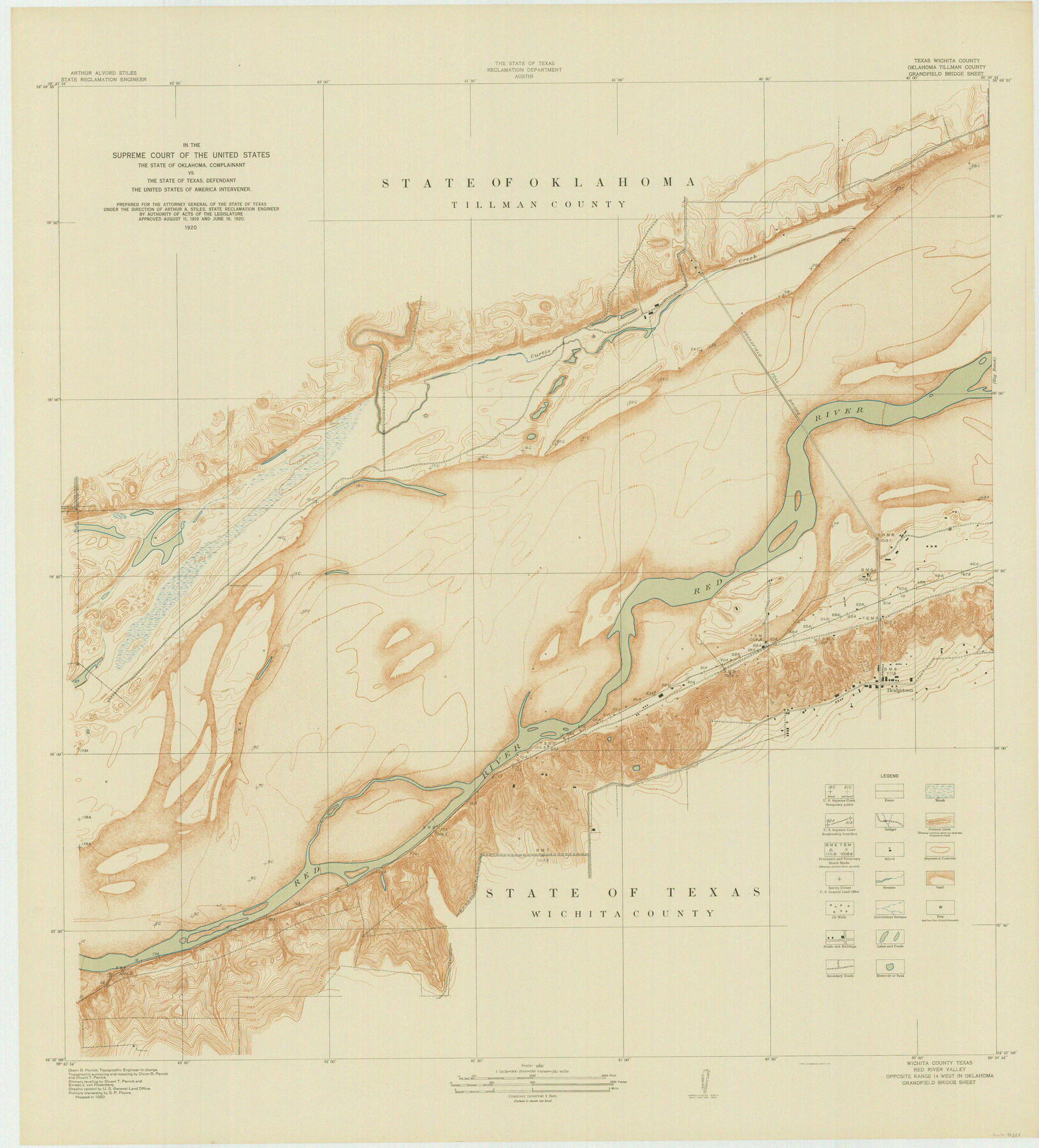
In the Supreme Court of the United States The State of Oklahoma, Complainant vs. The State of Texas, Defendant, The United States of America, Intervener - 1920
-
Map/Doc
75264
-
Collection
General Map Collection
-
Object Dates
1920 (Creation Date)
-
Subjects
Legal Texas Boundaries
-
Height x Width
39.4 x 35.7 inches
100.1 x 90.7 cm
Part of: General Map Collection
Nueces County Sketch File 12

Print $4.00
- Digital $50.00
Nueces County Sketch File 12
1848
Size 9.8 x 8.7 inches
Map/Doc 32528
Right-of-Way and Track Map, Texas State Railroad operated by the T. and N.O. R.R. Co.

Print $40.00
- Digital $50.00
Right-of-Way and Track Map, Texas State Railroad operated by the T. and N.O. R.R. Co.
1917
Size 24.7 x 56.0 inches
Map/Doc 64172
Coke County Sketch File 19

Print $20.00
- Digital $50.00
Coke County Sketch File 19
Size 18.5 x 25.0 inches
Map/Doc 11110
Upton County Rolled Sketch 34

Print $20.00
- Digital $50.00
Upton County Rolled Sketch 34
1951
Size 34.4 x 34.3 inches
Map/Doc 10050
Grayson County Working Sketch 13

Print $20.00
- Digital $50.00
Grayson County Working Sketch 13
1952
Size 31.1 x 38.0 inches
Map/Doc 63252
McLennan County Sketch File 1b

Print $4.00
- Digital $50.00
McLennan County Sketch File 1b
Size 8.3 x 8.1 inches
Map/Doc 31228
Flight Mission No. DQO-2K, Frame 84, Galveston County

Print $20.00
- Digital $50.00
Flight Mission No. DQO-2K, Frame 84, Galveston County
1952
Size 18.8 x 22.5 inches
Map/Doc 85011
Kaufman County Sketch File 11

Print $4.00
- Digital $50.00
Kaufman County Sketch File 11
1874
Size 10.2 x 8.4 inches
Map/Doc 28645
Hays County Sketch File 28

Print $20.00
- Digital $50.00
Hays County Sketch File 28
1912
Size 26.0 x 20.0 inches
Map/Doc 11750
[Pecos and Northern Texas Ry., Bailey Co., from Parmer Co. line through Lariat and Muleshoe to Lamb Co. line]
![64636, [Pecos and Northern Texas Ry., Bailey Co., from Parmer Co. line through Lariat and Muleshoe to Lamb Co. line], General Map Collection](https://historictexasmaps.com/wmedia_w700/maps/64636.tif.jpg)
Print $40.00
- Digital $50.00
[Pecos and Northern Texas Ry., Bailey Co., from Parmer Co. line through Lariat and Muleshoe to Lamb Co. line]
1912
Size 20.3 x 121.9 inches
Map/Doc 64636
Hutchinson County Working Sketch 3

Print $20.00
- Digital $50.00
Hutchinson County Working Sketch 3
Size 18.2 x 15.8 inches
Map/Doc 66361
Kinney County Working Sketch 27

Print $20.00
- Digital $50.00
Kinney County Working Sketch 27
1956
Size 23.1 x 25.1 inches
Map/Doc 70209
You may also like
Lamb County Sketch File 1 and 1a

Print $30.00
- Digital $50.00
Lamb County Sketch File 1 and 1a
Size 8.7 x 7.6 inches
Map/Doc 29337
Gaines County

Print $40.00
- Digital $50.00
Gaines County
1902
Size 49.7 x 38.6 inches
Map/Doc 89863
Edwards County Sketch File 41

Print $20.00
- Digital $50.00
Edwards County Sketch File 41
Size 33.7 x 22.7 inches
Map/Doc 11439
Randall County Rolled Sketch 3

Print $20.00
- Digital $50.00
Randall County Rolled Sketch 3
Size 22.0 x 24.9 inches
Map/Doc 7423
Culberson County Working Sketch 13

Print $20.00
- Digital $50.00
Culberson County Working Sketch 13
1922
Size 25.7 x 21.3 inches
Map/Doc 68465
Concho County Working Sketch 24

Print $20.00
- Digital $50.00
Concho County Working Sketch 24
1981
Size 35.0 x 44.2 inches
Map/Doc 68206
Hays County Boundary File 2a

Print $40.00
- Digital $50.00
Hays County Boundary File 2a
Size 9.0 x 25.0 inches
Map/Doc 54595
Motley County Working Sketch 8

Print $20.00
- Digital $50.00
Motley County Working Sketch 8
1983
Size 32.1 x 30.6 inches
Map/Doc 71213
Matagorda County Working Sketch 18

Print $20.00
- Digital $50.00
Matagorda County Working Sketch 18
1961
Size 31.2 x 41.8 inches
Map/Doc 70876
Controlled Mosaic by Jack Amman Photogrammetric Engineers, Inc - Sheet 41

Print $20.00
- Digital $50.00
Controlled Mosaic by Jack Amman Photogrammetric Engineers, Inc - Sheet 41
1954
Size 20.0 x 24.0 inches
Map/Doc 83496
Texas Boundary Line

Print $20.00
- Digital $50.00
Texas Boundary Line
Size 21.2 x 11.8 inches
Map/Doc 92068
Smith County Rolled Sketch 6D2

Print $2.00
- Digital $50.00
Smith County Rolled Sketch 6D2
Size 11.3 x 8.9 inches
Map/Doc 76014