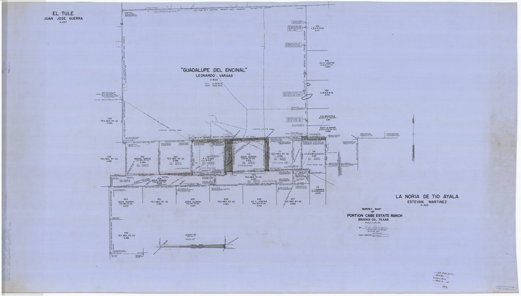
Brooks County Rolled Sketch 23
Survey map of Portion Cage Estate Ranch
-
Map/Doc
8538
-
Collection
General Map Collection
-
Object Dates
1945 (Survey Date)
1945/3/8 (File Date)
-
People and Organizations
H.L. Ohlinger (Surveyor/Engineer)
J.C. Schwartz (Chainman/Field Personnel)
Paul Guizerix (Chainman/Field Personnel)
-
Counties
Brooks
-
Subjects
Surveying Rolled Sketch
-
Height x Width
42.4 x 74.4 inches
107.7 x 189.0 cm
-
Medium
linen, manuscript
-
Scale
1" = 400 varas
-
Comments
See SF 14680 for surveyor's report.
Part of: General Map Collection
Kimble County Working Sketch 44

Print $20.00
- Digital $50.00
Kimble County Working Sketch 44
1950
Size 29.8 x 36.2 inches
Map/Doc 70112
Copy of Surveyor's Field Book, Morris Browning - In Blocks 7, 5 & 4, I&GNRRCo., Hutchinson and Carson Counties, Texas

Print $2.00
- Digital $50.00
Copy of Surveyor's Field Book, Morris Browning - In Blocks 7, 5 & 4, I&GNRRCo., Hutchinson and Carson Counties, Texas
1888
Size 7.0 x 8.9 inches
Map/Doc 62266
Milam County Working Sketch 7

Print $40.00
- Digital $50.00
Milam County Working Sketch 7
1969
Size 42.7 x 48.0 inches
Map/Doc 71022
America's Fun-Tier: Texas 1966 Official State Highway Map

Digital $50.00
America's Fun-Tier: Texas 1966 Official State Highway Map
Size 28.2 x 36.5 inches
Map/Doc 94324
Henderson County Working Sketch 24

Print $20.00
- Digital $50.00
Henderson County Working Sketch 24
1952
Size 29.3 x 22.9 inches
Map/Doc 66157
Andrews County Boundary File 2a

Print $14.00
- Digital $50.00
Andrews County Boundary File 2a
Size 11.2 x 8.9 inches
Map/Doc 49690


Denton County Rolled Sketch 7

Print $20.00
- Digital $50.00
Denton County Rolled Sketch 7
2007
Size 24.5 x 19.3 inches
Map/Doc 87941
Aransas County Boundary File 5a

Print $14.00
- Digital $50.00
Aransas County Boundary File 5a
Size 11.3 x 8.7 inches
Map/Doc 49796
Rusk County Rolled Sketch 10

Print $18.00
- Digital $50.00
Rusk County Rolled Sketch 10
Size 9.7 x 11.3 inches
Map/Doc 48864
Sabine River, Toll Bridge Sheet

Print $40.00
- Digital $50.00
Sabine River, Toll Bridge Sheet
1933
Size 27.8 x 51.9 inches
Map/Doc 65136
You may also like
Reagan County Rolled Sketch 8

Print $20.00
- Digital $50.00
Reagan County Rolled Sketch 8
Size 30.2 x 26.7 inches
Map/Doc 7436
Map of section no. 6 of a survey of Padre Island made for the Office of the Attorney General of the State of Texas

Print $40.00
- Digital $50.00
Map of section no. 6 of a survey of Padre Island made for the Office of the Attorney General of the State of Texas
1941
Size 57.9 x 40.8 inches
Map/Doc 2262
Hudspeth County Rolled Sketch 47

Print $20.00
- Digital $50.00
Hudspeth County Rolled Sketch 47
1963
Size 22.2 x 25.9 inches
Map/Doc 6255
Johnson County Boundary File 51

Print $66.00
- Digital $50.00
Johnson County Boundary File 51
Size 8.5 x 4.2 inches
Map/Doc 55589
Flight Mission No. DQO-8K, Frame 14, Galveston County

Print $20.00
- Digital $50.00
Flight Mission No. DQO-8K, Frame 14, Galveston County
1952
Size 18.7 x 22.4 inches
Map/Doc 85137
Texas Official Travel Map

Digital $50.00
Texas Official Travel Map
Size 33.4 x 36.4 inches
Map/Doc 94424
Jack County Sketch File 2

Print $6.00
- Digital $50.00
Jack County Sketch File 2
1856
Size 8.8 x 8.0 inches
Map/Doc 27501
Val Verde County Boundary File 103a

Print $8.00
- Digital $50.00
Val Verde County Boundary File 103a
Size 14.4 x 8.8 inches
Map/Doc 59600
Upton County Working Sketch 44

Print $20.00
- Digital $50.00
Upton County Working Sketch 44
1962
Size 19.2 x 25.5 inches
Map/Doc 69540
Oil and Gas Fields in the State of Texas

Print $40.00
Oil and Gas Fields in the State of Texas
1927
Size 58.2 x 38.1 inches
Map/Doc 76303
Ward County Rolled Sketch 25

Print $20.00
- Digital $50.00
Ward County Rolled Sketch 25
1970
Size 38.7 x 19.9 inches
Map/Doc 8165
Crosby County Sketch File 17

Print $4.00
- Digital $50.00
Crosby County Sketch File 17
1907
Size 4.2 x 8.9 inches
Map/Doc 20069