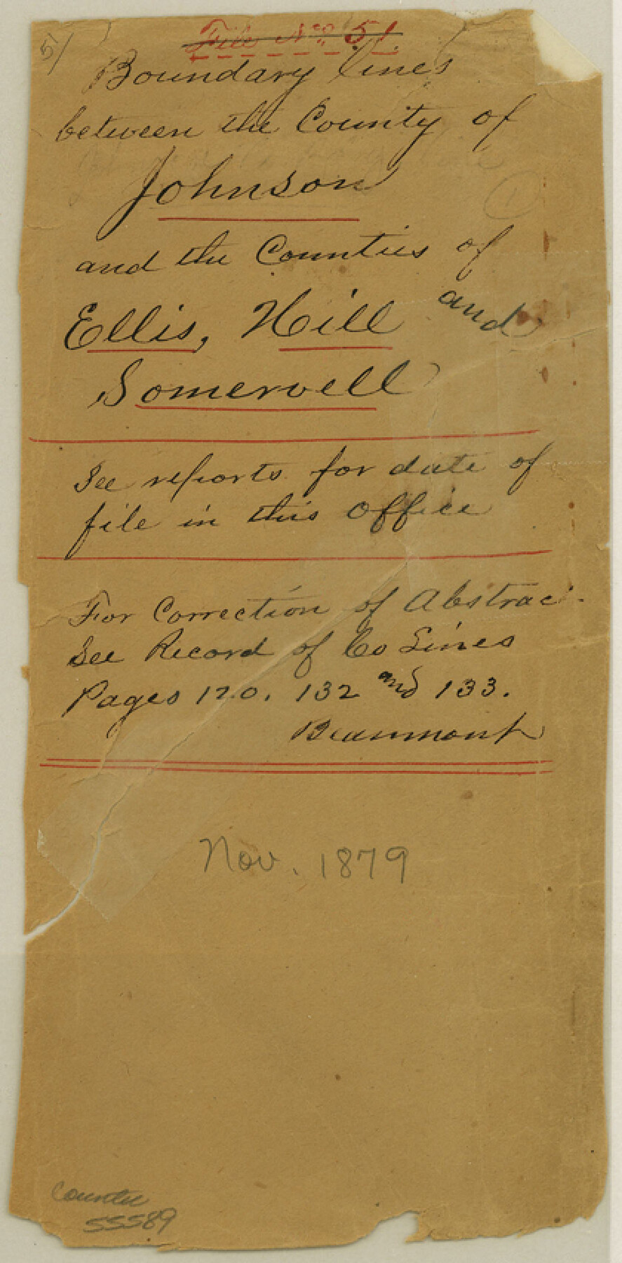
Johnson County Boundary File 51
Boundary lines between the County of Johnson and the Counties of Ellis, Hill and Somervell
-
Map/Doc
55589
-
Collection
General Map Collection
-
Counties
Johnson
-
Subjects
County Boundaries
-
Height x Width
8.5 x 4.2 inches
21.6 x 10.7 cm
Part of: General Map Collection
Irion County Rolled Sketch 2

Print $20.00
- Digital $50.00
Irion County Rolled Sketch 2
Size 27.8 x 39.7 inches
Map/Doc 6317
Andrews County Working Sketch 1

Print $20.00
- Digital $50.00
Andrews County Working Sketch 1
1946
Size 40.4 x 37.3 inches
Map/Doc 67047
Edwards County Rolled Sketch 24

Print $20.00
- Digital $50.00
Edwards County Rolled Sketch 24
1953
Size 29.9 x 38.0 inches
Map/Doc 5810
Val Verde County Sketch File Z9

Print $20.00
- Digital $50.00
Val Verde County Sketch File Z9
1891
Size 15.9 x 24.8 inches
Map/Doc 12554
Kleberg County Rolled Sketch 10-7

Print $20.00
- Digital $50.00
Kleberg County Rolled Sketch 10-7
1953
Size 37.3 x 34.5 inches
Map/Doc 9401
Comanche County Boundary File 1

Print $20.00
- Digital $50.00
Comanche County Boundary File 1
Size 14.4 x 8.8 inches
Map/Doc 51778
Revolutionary Map of Texas, 1836

Print $27.06
Revolutionary Map of Texas, 1836
1986
Size 32.7 x 26.7 inches
Map/Doc 89022
Henderson County Rolled Sketch 11

Print $20.00
- Digital $50.00
Henderson County Rolled Sketch 11
1915
Size 29.4 x 42.4 inches
Map/Doc 75950
Lipscomb County Boundary File 16

Print $2.00
- Digital $50.00
Lipscomb County Boundary File 16
Size 11.5 x 7.1 inches
Map/Doc 56386
Presidio County Rolled Sketch 102

Print $20.00
- Digital $50.00
Presidio County Rolled Sketch 102
1957
Size 19.3 x 13.8 inches
Map/Doc 7385
[Map of Sterling County]
![4055, [Map of Sterling County], General Map Collection](https://historictexasmaps.com/wmedia_w700/maps/4055.tif.jpg)
Print $20.00
- Digital $50.00
[Map of Sterling County]
1919
Size 30.2 x 22.8 inches
Map/Doc 4055
Guadalupe County Sketch File 5a

Print $12.00
- Digital $50.00
Guadalupe County Sketch File 5a
1869
Size 12.6 x 8.0 inches
Map/Doc 42205
You may also like
Flight Mission No. BRE-1P, Frame 141, Nueces County

Print $20.00
- Digital $50.00
Flight Mission No. BRE-1P, Frame 141, Nueces County
1956
Size 18.7 x 22.5 inches
Map/Doc 86701
Galveston County Sketch File 70

Print $26.00
- Digital $50.00
Galveston County Sketch File 70
1983
Size 11.3 x 8.7 inches
Map/Doc 23928
Chambers County Sketch File 4b

Print $27.00
- Digital $50.00
Chambers County Sketch File 4b
1950
Size 8.6 x 14.2 inches
Map/Doc 17530
Aransas County Sketch File 31

Print $46.00
- Digital $50.00
Aransas County Sketch File 31
1919
Size 14.2 x 8.7 inches
Map/Doc 13274
Newton County Working Sketch 20

Print $20.00
- Digital $50.00
Newton County Working Sketch 20
1951
Size 22.7 x 15.7 inches
Map/Doc 71266
King County Sketch File 9

Print $20.00
- Digital $50.00
King County Sketch File 9
Size 23.5 x 33.0 inches
Map/Doc 11937
Floyd County Sketch File 13

Print $36.00
- Digital $50.00
Floyd County Sketch File 13
1913
Size 11.4 x 9.0 inches
Map/Doc 22713
Flight Mission No. CUG-3P, Frame 80, Kleberg County

Print $20.00
- Digital $50.00
Flight Mission No. CUG-3P, Frame 80, Kleberg County
1956
Size 18.7 x 22.4 inches
Map/Doc 86255
Orange County Rolled Sketch 30

Print $20.00
- Digital $50.00
Orange County Rolled Sketch 30
1960
Size 32.4 x 34.9 inches
Map/Doc 9650
Cooke County Sketch File 46

Print $36.00
- Digital $50.00
Cooke County Sketch File 46
2002
Size 10.5 x 8.0 inches
Map/Doc 82578
Schleicher County Rolled Sketch 24

Print $20.00
- Digital $50.00
Schleicher County Rolled Sketch 24
Size 29.1 x 15.9 inches
Map/Doc 7763
Map Showing Resurvey of Capitol Leagues, Bailey, Lamb & Castro Co's.

Print $20.00
- Digital $50.00
Map Showing Resurvey of Capitol Leagues, Bailey, Lamb & Castro Co's.
1918
Size 17.3 x 42.5 inches
Map/Doc 1758