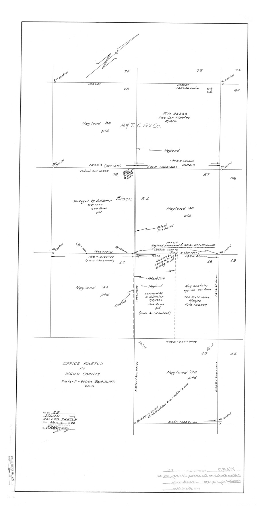
Ward County Rolled Sketch 25
Office sketch in Ward County [showing surveys 45, 47, 48, 57, 58, 63, and 64, H. & T. C. Ry. Co. Block 34]
-
Map/Doc
8165
-
Collection
General Map Collection
-
Object Dates
1970/9/16 (Creation Date)
1970/11/6 (File Date)
-
Counties
Ward
-
Subjects
Surveying Rolled Sketch
-
Height x Width
38.7 x 19.9 inches
98.3 x 50.5 cm
-
Scale
1" = 300 varas
Part of: General Map Collection
Montgomery County Rolled Sketch 47

Print $20.00
- Digital $50.00
Montgomery County Rolled Sketch 47
2009
Size 36.5 x 24.6 inches
Map/Doc 89032
Map of Augustine Cty.

Print $20.00
- Digital $50.00
Map of Augustine Cty.
1839
Size 22.9 x 14.6 inches
Map/Doc 165
[Map of Line Dividing Fannin and Nacogdoches Districts]
![81919, [Map of Line Dividing Fannin and Nacogdoches Districts], General Map Collection](https://historictexasmaps.com/wmedia_w700/maps/81919-1.tif.jpg)
Print $2.00
- Digital $50.00
[Map of Line Dividing Fannin and Nacogdoches Districts]
1850
Size 11.0 x 8.6 inches
Map/Doc 81919
Gregg County Working Sketch Graphic Index

Print $20.00
- Digital $50.00
Gregg County Working Sketch Graphic Index
1933
Size 32.4 x 29.5 inches
Map/Doc 76559
Nueva Hispania Tabula Nova

Print $20.00
- Digital $50.00
Nueva Hispania Tabula Nova
1561
Size 9.4 x 12.3 inches
Map/Doc 93796
Map of Upton County

Print $20.00
- Digital $50.00
Map of Upton County
1899
Size 46.0 x 40.2 inches
Map/Doc 63087
Ector County Rolled Sketch 7

Print $20.00
- Digital $50.00
Ector County Rolled Sketch 7
1936
Size 37.1 x 30.4 inches
Map/Doc 5778
Goliad County Working Sketch 16

Print $20.00
- Digital $50.00
Goliad County Working Sketch 16
1949
Size 30.0 x 46.9 inches
Map/Doc 63206
Potter County Boundary File 4b

Print $20.00
- Digital $50.00
Potter County Boundary File 4b
Size 9.2 x 32.9 inches
Map/Doc 58012
McLennan County Sketch File 31

Print $22.00
- Digital $50.00
McLennan County Sketch File 31
Size 14.2 x 17.2 inches
Map/Doc 31306
Carta Etnografica

Print $20.00
- Digital $50.00
Carta Etnografica
1897
Size 26.2 x 34.1 inches
Map/Doc 96798
Hydrographic Survey H-6396 of Outer Coast of Padre Island; Gulf of Mexico

Print $40.00
- Digital $50.00
Hydrographic Survey H-6396 of Outer Coast of Padre Island; Gulf of Mexico
1938
Size 54.4 x 33.5 inches
Map/Doc 2699
You may also like
Hunt County Rolled Sketch 5

Print $20.00
- Digital $50.00
Hunt County Rolled Sketch 5
1966
Size 24.6 x 24.2 inches
Map/Doc 6276
Flight Mission No. DAG-21K, Frame 120, Matagorda County

Print $20.00
- Digital $50.00
Flight Mission No. DAG-21K, Frame 120, Matagorda County
1952
Size 18.5 x 22.3 inches
Map/Doc 86446
Aransas County Rolled Sketch 27

Print $20.00
- Digital $50.00
Aransas County Rolled Sketch 27
1983
Size 24.9 x 35.4 inches
Map/Doc 5059
Bee County Working Sketch 2
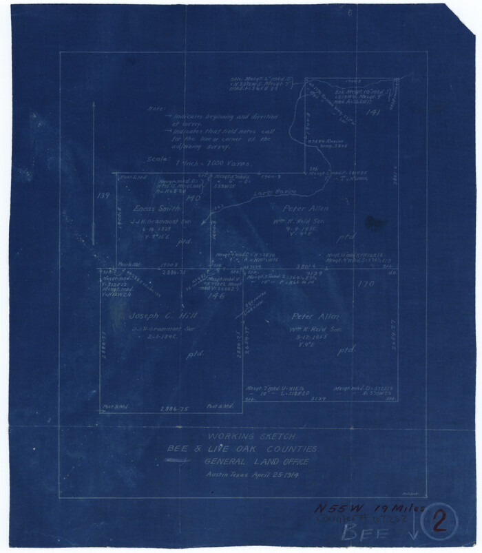
Print $3.00
- Digital $50.00
Bee County Working Sketch 2
1914
Size 11.0 x 9.6 inches
Map/Doc 67252
Mrs. Don D. Kinnebrew Farm Section 72, Block A

Print $20.00
- Digital $50.00
Mrs. Don D. Kinnebrew Farm Section 72, Block A
Size 15.6 x 18.0 inches
Map/Doc 92290
Flight Mission No. DQO-1K, Frame 92, Galveston County

Print $20.00
- Digital $50.00
Flight Mission No. DQO-1K, Frame 92, Galveston County
1952
Size 18.9 x 22.6 inches
Map/Doc 84988
Kerr County Sketch File 4

Print $10.00
- Digital $50.00
Kerr County Sketch File 4
1873
Size 8.1 x 7.7 inches
Map/Doc 28860
San Patricio County Rolled Sketch 34

Print $20.00
- Digital $50.00
San Patricio County Rolled Sketch 34
Size 25.8 x 26.2 inches
Map/Doc 7584
Intracoastal Waterway in Texas - Corpus Christi to Point Isabel including Arroyo Colorado to Mo. Pac. R.R. Bridge Near Harlingen

Print $20.00
- Digital $50.00
Intracoastal Waterway in Texas - Corpus Christi to Point Isabel including Arroyo Colorado to Mo. Pac. R.R. Bridge Near Harlingen
1933
Size 28.2 x 41.3 inches
Map/Doc 61873
Fort Bend County Sketch File 3a

Print $6.00
- Digital $50.00
Fort Bend County Sketch File 3a
1874
Size 8.3 x 8.0 inches
Map/Doc 22882
El Paso County Working Sketch 9

Print $20.00
- Digital $50.00
El Paso County Working Sketch 9
1955
Size 28.0 x 25.0 inches
Map/Doc 69031
[Aransas National Wildlife Refuge]
![3119, [Aransas National Wildlife Refuge], General Map Collection](https://historictexasmaps.com/wmedia_w700/maps/3119-1.tif.jpg)
Print $40.00
- Digital $50.00
[Aransas National Wildlife Refuge]
1952
Size 55.9 x 43.4 inches
Map/Doc 3119