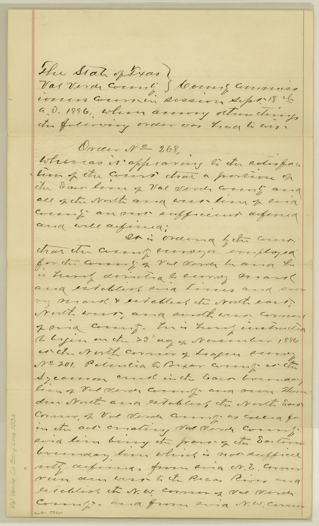
Val Verde County Boundary File 103a
[Court Order regarding the Val Verde Boundary lines]
-
Map/Doc
59600
-
Collection
General Map Collection
-
Counties
Val Verde
-
Subjects
County Boundaries
-
Height x Width
14.4 x 8.8 inches
36.6 x 22.4 cm
Part of: General Map Collection
Jeff Davis County Working Sketch 37

Print $20.00
- Digital $50.00
Jeff Davis County Working Sketch 37
1979
Size 31.6 x 36.6 inches
Map/Doc 66532
Map of Brazoria

Print $20.00
- Digital $50.00
Map of Brazoria
1931
Size 20.2 x 26.7 inches
Map/Doc 80134
Borden County Working Sketch Graphic Index

Print $20.00
- Digital $50.00
Borden County Working Sketch Graphic Index
1977
Size 45.7 x 34.8 inches
Map/Doc 76468
Irion County Sketch File 7

Print $4.00
- Digital $50.00
Irion County Sketch File 7
1927
Size 11.1 x 7.1 inches
Map/Doc 27471
Travis County Boundary File 4a

Print $40.00
- Digital $50.00
Travis County Boundary File 4a
Size 27.9 x 17.8 inches
Map/Doc 59428
[Surveys East of river copied from U.S. map of Township No. 6 South, Range No. 9 West of the Indian Meridian, Oklahoma]
![75185, [Surveys East of river copied from U.S. map of Township No. 6 South, Range No. 9 West of the Indian Meridian, Oklahoma], General Map Collection](https://historictexasmaps.com/wmedia_w700/maps/75185.tif.jpg)
Print $2.00
- Digital $50.00
[Surveys East of river copied from U.S. map of Township No. 6 South, Range No. 9 West of the Indian Meridian, Oklahoma]
Size 13.3 x 9.0 inches
Map/Doc 75185
Menard County Boundary File 12

Print $66.00
- Digital $50.00
Menard County Boundary File 12
Size 8.7 x 8.7 inches
Map/Doc 57099
Jeff Davis County Texas

Print $20.00
- Digital $50.00
Jeff Davis County Texas
Size 16.1 x 21.1 inches
Map/Doc 4572
Anderson County Sketch File 29

Print $4.00
- Digital $50.00
Anderson County Sketch File 29
1873
Size 10.4 x 8.2 inches
Map/Doc 12814
Leon County Sketch File 26

Print $20.00
- Digital $50.00
Leon County Sketch File 26
1948
Size 11.4 x 8.6 inches
Map/Doc 29801
Flight Mission No. DQO-12K, Frame 40, Galveston County

Print $20.00
- Digital $50.00
Flight Mission No. DQO-12K, Frame 40, Galveston County
1952
Size 18.6 x 22.3 inches
Map/Doc 85230
Red River County Working Sketch 62

Print $20.00
- Digital $50.00
Red River County Working Sketch 62
1973
Size 27.1 x 40.0 inches
Map/Doc 72045
You may also like
Jeff Davis County Working Sketch 36

Print $20.00
- Digital $50.00
Jeff Davis County Working Sketch 36
1979
Size 37.2 x 28.8 inches
Map/Doc 66531
[Surveys along Cypress Creek]
![155, [Surveys along Cypress Creek], General Map Collection](https://historictexasmaps.com/wmedia_w700/maps/155.tif.jpg)
Print $2.00
- Digital $50.00
[Surveys along Cypress Creek]
1844
Size 6.0 x 6.1 inches
Map/Doc 155
Crockett County Working Sketch 86

Print $20.00
- Digital $50.00
Crockett County Working Sketch 86
1976
Size 34.7 x 38.0 inches
Map/Doc 68419
General Highway Map, Chambers County, Texas

Print $20.00
General Highway Map, Chambers County, Texas
1940
Size 18.4 x 25.3 inches
Map/Doc 79044
Flight Mission No. DQO-8K, Frame 144, Galveston County

Print $20.00
- Digital $50.00
Flight Mission No. DQO-8K, Frame 144, Galveston County
1952
Size 18.7 x 22.5 inches
Map/Doc 85206
Comanche County Sketch File 16

Print $6.00
- Digital $50.00
Comanche County Sketch File 16
Size 11.8 x 11.5 inches
Map/Doc 19082
Gaines County Working Sketch 2

Print $20.00
- Digital $50.00
Gaines County Working Sketch 2
1939
Size 29.4 x 39.9 inches
Map/Doc 69302
Callahan County Rolled Sketch 1

Print $20.00
- Digital $50.00
Callahan County Rolled Sketch 1
1944
Size 26.9 x 26.3 inches
Map/Doc 5379
Andrews County Rolled Sketch 13

Print $20.00
- Digital $50.00
Andrews County Rolled Sketch 13
1934
Size 38.3 x 26.2 inches
Map/Doc 77163
Robertson County Rolled Sketch 2

Print $43.00
- Digital $50.00
Robertson County Rolled Sketch 2
1974
Size 9.6 x 15.1 inches
Map/Doc 48861
Young County Rolled Sketch 15

Print $20.00
- Digital $50.00
Young County Rolled Sketch 15
Size 18.0 x 22.7 inches
Map/Doc 8303
