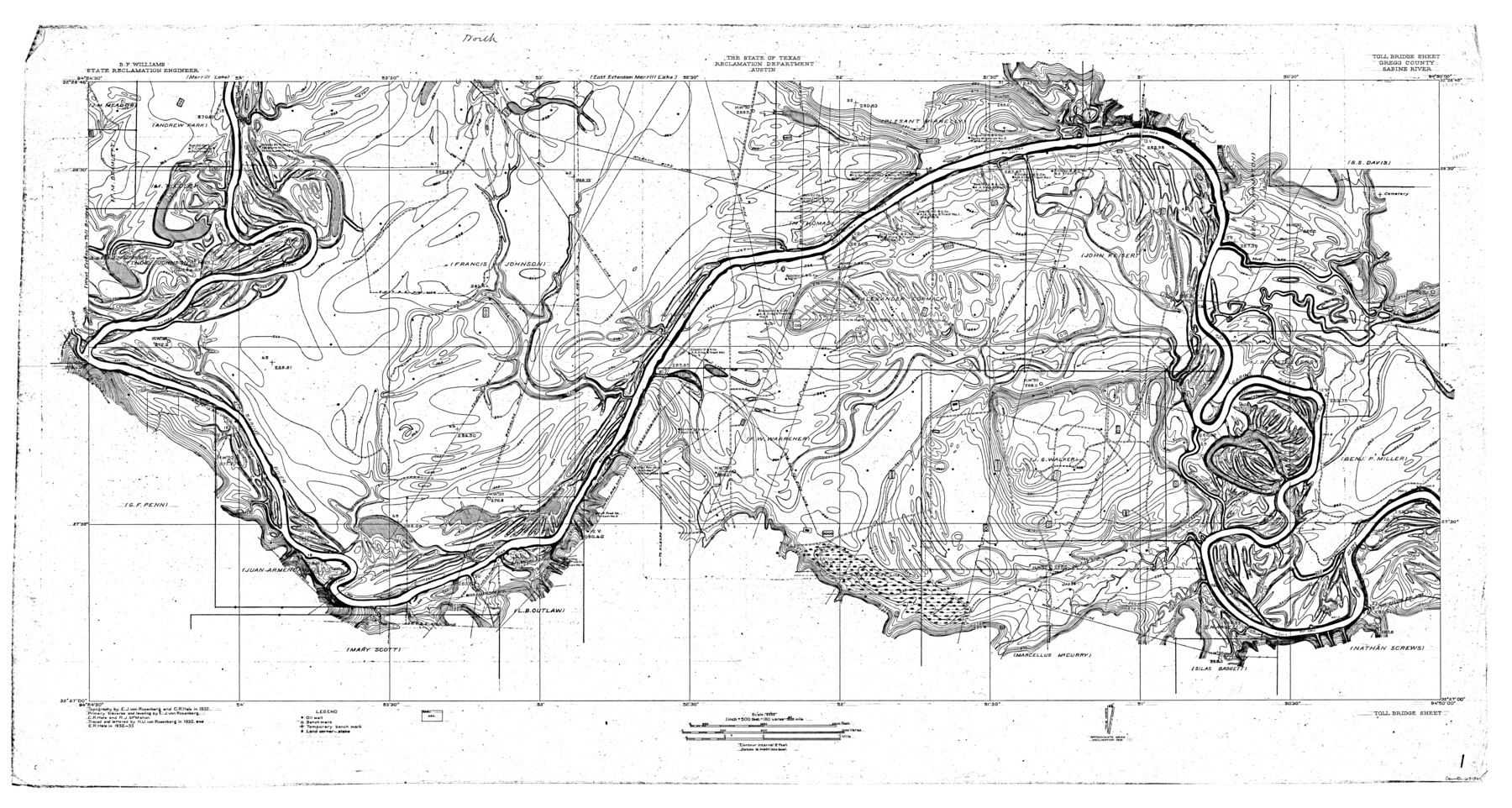
Sabine River, Toll Bridge Sheet
-
Map/Doc
65136
-
Collection
General Map Collection
-
Object Dates
1933 (Creation Date)
-
People and Organizations
Texas State Reclamation Department (Publisher)
H. U von Rosenberg (Compiler)
H. U von Rosenberg (Draftsman)
Curtis R. Hale (Compiler)
Curtis R. Hale (Draftsman)
Curtis R. Hale (Surveyor/Engineer)
R.J. McMahon (Surveyor/Engineer)
E.J. von Rosenberg (Surveyor/Engineer)
-
Counties
Gregg
-
Subjects
River Surveys Topographic
-
Height x Width
27.8 x 51.9 inches
70.6 x 131.8 cm
-
Comments
Toll Bridge Sheet located west of the West Extension Toll Bridge Sheet, north of the Merrill Lake Sheet and east of the East Extension Merrill Lake Sheet.
Part of: General Map Collection
Menard County Boundary File 11

Print $2.00
- Digital $50.00
Menard County Boundary File 11
Size 11.2 x 8.7 inches
Map/Doc 57098
Coleman County Sketch File 45a

Print $4.00
- Digital $50.00
Coleman County Sketch File 45a
1897
Size 9.8 x 6.2 inches
Map/Doc 18791
Ellis County Sketch File 14

Print $40.00
- Digital $50.00
Ellis County Sketch File 14
1861
Size 12.9 x 16.1 inches
Map/Doc 21854
Tarrant County Sketch File 25

Print $4.00
- Digital $50.00
Tarrant County Sketch File 25
1873
Size 8.2 x 8.6 inches
Map/Doc 37737
Houston Ship Channel, Alexander Island to Carpenter Bayou

Print $20.00
- Digital $50.00
Houston Ship Channel, Alexander Island to Carpenter Bayou
1973
Size 35.6 x 46.3 inches
Map/Doc 69909
Hunt County Boundary File 5

Print $6.00
- Digital $50.00
Hunt County Boundary File 5
Size 11.2 x 8.9 inches
Map/Doc 55222
Wichita County Working Sketch 19

Print $20.00
- Digital $50.00
Wichita County Working Sketch 19
1949
Size 18.1 x 30.9 inches
Map/Doc 72529
Newton County Sketch File 22

Print $4.00
- Digital $50.00
Newton County Sketch File 22
1890
Size 14.2 x 8.7 inches
Map/Doc 32401
Blocks 56 and 57, Townships 1 and 2, resurvey of Texas & Pacific Railway Lands in the eighty mile reservation

Print $20.00
- Digital $50.00
Blocks 56 and 57, Townships 1 and 2, resurvey of Texas & Pacific Railway Lands in the eighty mile reservation
1931
Size 41.4 x 31.4 inches
Map/Doc 2246
Orange County Working Sketch 40

Print $20.00
- Digital $50.00
Orange County Working Sketch 40
1979
Size 19.2 x 12.1 inches
Map/Doc 71372
Foard County Boundary File 4a

Print $40.00
- Digital $50.00
Foard County Boundary File 4a
Size 16.9 x 45.4 inches
Map/Doc 53522
Flight Mission No. CGI-3N, Frame 143, Cameron County

Print $20.00
- Digital $50.00
Flight Mission No. CGI-3N, Frame 143, Cameron County
1954
Size 18.5 x 22.1 inches
Map/Doc 84616
You may also like
Reeves County Rolled Sketch 33

Print $20.00
- Digital $50.00
Reeves County Rolled Sketch 33
Size 24.2 x 36.5 inches
Map/Doc 7502
[Surveys along the Leon River]
![20, [Surveys along the Leon River], General Map Collection](https://historictexasmaps.com/wmedia_w700/maps/20-1.tif.jpg)
Print $20.00
- Digital $50.00
[Surveys along the Leon River]
1840
Size 20.3 x 6.6 inches
Map/Doc 20
Flight Mission No. BRE-1P, Frame 146, Nueces County

Print $20.00
- Digital $50.00
Flight Mission No. BRE-1P, Frame 146, Nueces County
1956
Size 18.5 x 22.6 inches
Map/Doc 86706
J. De Cordova's Map of the State of Texas Compiled from the records of the General Land Office of the State

Print $20.00
J. De Cordova's Map of the State of Texas Compiled from the records of the General Land Office of the State
1872
Size 34.3 x 31.9 inches
Map/Doc 76216
Lamb County Rolled Sketch 7

Print $20.00
- Digital $50.00
Lamb County Rolled Sketch 7
Size 45.6 x 26.3 inches
Map/Doc 9415
Newton County Sketch File 5

Print $8.00
- Digital $50.00
Newton County Sketch File 5
Size 8.2 x 12.8 inches
Map/Doc 32368
Fort Bend County Working Sketch 11

Print $20.00
- Digital $50.00
Fort Bend County Working Sketch 11
1938
Size 33.2 x 29.1 inches
Map/Doc 69217
Map of Polk County

Print $20.00
- Digital $50.00
Map of Polk County
1856
Size 22.1 x 23.7 inches
Map/Doc 3961
Denton County Sketch File 33

Print $4.00
- Digital $50.00
Denton County Sketch File 33
Size 8.2 x 12.4 inches
Map/Doc 20760
St. L. S-W. Ry. of Texas Map of Lufkin Branch in Cherokee County Texas

Print $40.00
- Digital $50.00
St. L. S-W. Ry. of Texas Map of Lufkin Branch in Cherokee County Texas
1912
Size 22.7 x 64.3 inches
Map/Doc 64019
Bosque County Sketch File 19

Print $4.00
- Digital $50.00
Bosque County Sketch File 19
1863
Size 12.9 x 6.2 inches
Map/Doc 14794
Flight Mission No. CUG-2P, Frame 66, Kleberg County

Print $20.00
- Digital $50.00
Flight Mission No. CUG-2P, Frame 66, Kleberg County
1956
Size 18.5 x 22.2 inches
Map/Doc 86203