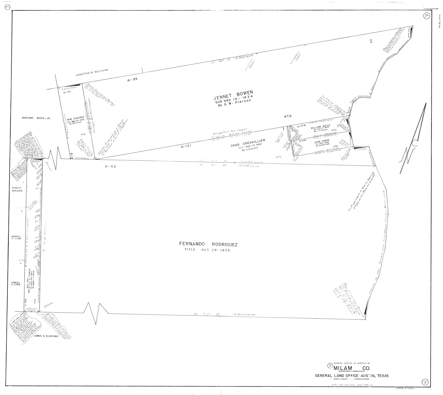
Milam County Working Sketch 7
-
Map/Doc
71022
-
Collection
General Map Collection
-
Object Dates
6/17/1969 (Creation Date)
-
People and Organizations
Herbert H. Ulbricht (Draftsman)
-
Counties
Milam
-
Subjects
Surveying Working Sketch
-
Height x Width
42.7 x 48.0 inches
108.5 x 121.9 cm
-
Scale
1" = 300 varas
Part of: General Map Collection
[Map of Parker County]
![3948, [Map of Parker County], General Map Collection](https://historictexasmaps.com/wmedia_w700/maps/3948.tif.jpg)
Print $20.00
- Digital $50.00
[Map of Parker County]
1889
Size 25.9 x 32.9 inches
Map/Doc 3948
Collin County Boundary File 18 and 18a

Print $8.00
- Digital $50.00
Collin County Boundary File 18 and 18a
Size 7.8 x 4.0 inches
Map/Doc 51717
Bailey County Rolled Sketch 3

Print $20.00
- Digital $50.00
Bailey County Rolled Sketch 3
1913
Size 15.2 x 13.8 inches
Map/Doc 5110
Map of Panola County

Print $20.00
- Digital $50.00
Map of Panola County
1871
Size 16.5 x 17.7 inches
Map/Doc 3938
Stonewall County Sketch File 15

Print $40.00
- Digital $50.00
Stonewall County Sketch File 15
1905
Size 14.3 x 8.7 inches
Map/Doc 37255
Edwards County Working Sketch 60

Print $20.00
- Digital $50.00
Edwards County Working Sketch 60
1954
Size 20.5 x 43.7 inches
Map/Doc 68936
Red River County Sketch File 27

Print $4.00
- Digital $50.00
Red River County Sketch File 27
1848
Size 12.8 x 8.3 inches
Map/Doc 35163
Flight Mission No. BRE-3P, Frame 80, Nueces County

Print $20.00
- Digital $50.00
Flight Mission No. BRE-3P, Frame 80, Nueces County
1956
Size 18.7 x 22.6 inches
Map/Doc 86821
Texas Gulf Coast from the Sabine River to the Rio Grande Showing Location of Navigation Districts

Print $20.00
- Digital $50.00
Texas Gulf Coast from the Sabine River to the Rio Grande Showing Location of Navigation Districts
1954
Size 45.0 x 43.8 inches
Map/Doc 73596

Hall County Sketch File 5

Print $20.00
- Digital $50.00
Hall County Sketch File 5
1884
Size 18.9 x 24.1 inches
Map/Doc 11602
Tarrant County Working Sketch 5

Print $20.00
- Digital $50.00
Tarrant County Working Sketch 5
1980
Size 27.7 x 27.3 inches
Map/Doc 62422
You may also like
Lavaca County Rolled Sketch 4

Print $20.00
- Digital $50.00
Lavaca County Rolled Sketch 4
1961
Size 43.6 x 37.1 inches
Map/Doc 9420
Brown County Sketch File 7

Print $6.00
- Digital $50.00
Brown County Sketch File 7
1860
Size 13.0 x 8.1 inches
Map/Doc 16590
[Blocks 34-36, Township 2N]
![92027, [Blocks 34-36, Township 2N], Twichell Survey Records](https://historictexasmaps.com/wmedia_w700/maps/92027-1.tif.jpg)
Print $20.00
- Digital $50.00
[Blocks 34-36, Township 2N]
Size 36.8 x 24.2 inches
Map/Doc 92027
Presidio County Working Sketch 59

Print $20.00
- Digital $50.00
Presidio County Working Sketch 59
1956
Size 20.6 x 22.6 inches
Map/Doc 71736
Galveston County Rolled Sketch 39

Print $20.00
- Digital $50.00
Galveston County Rolled Sketch 39
Size 18.1 x 21.5 inches
Map/Doc 45207
Eastland County

Print $20.00
- Digital $50.00
Eastland County
1945
Size 41.8 x 42.0 inches
Map/Doc 77268
Laguna Madre from Lone Palmetto Triangulation Station to Gum Pen Triangulation Station

Print $20.00
- Digital $50.00
Laguna Madre from Lone Palmetto Triangulation Station to Gum Pen Triangulation Station
1881
Size 16.2 x 27.5 inches
Map/Doc 73497
Flight Mission No. BRE-4P, Frame 167, Nueces County

Print $20.00
- Digital $50.00
Flight Mission No. BRE-4P, Frame 167, Nueces County
1956
Size 18.6 x 22.5 inches
Map/Doc 86830
Map of Chocolate Bay, west portion of West Bay & vicinity, Brazoria & Galveston Counties showing subdivision for mineral development

Print $40.00
- Digital $50.00
Map of Chocolate Bay, west portion of West Bay & vicinity, Brazoria & Galveston Counties showing subdivision for mineral development
1948
Size 42.2 x 55.2 inches
Map/Doc 2974
Haskell County Boundary File 4a

Print $62.00
- Digital $50.00
Haskell County Boundary File 4a
Size 9.0 x 4.5 inches
Map/Doc 54545
Collingsworth County Rolled Sketch 1

Print $40.00
- Digital $50.00
Collingsworth County Rolled Sketch 1
1941
Size 54.2 x 24.0 inches
Map/Doc 9664
Erath County Working Sketch 52

Print $20.00
- Digital $50.00
Erath County Working Sketch 52
1992
Size 33.9 x 33.6 inches
Map/Doc 69134