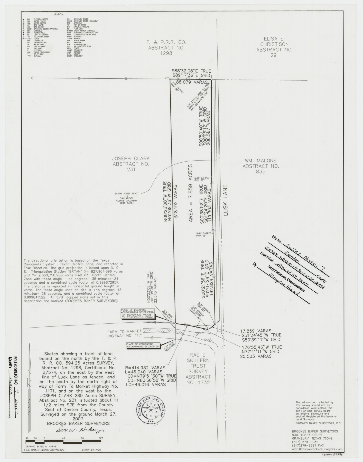
Denton County Rolled Sketch 7
Sketch showing a tract of land [bound on the north by A-1298, on the east by west line of Luck Lane as fenced, on the south by the north ROW of FM 1171, on the west by A-231]
-
Map/Doc
87941
-
Collection
General Map Collection
-
Object Dates
2007/3/27 (Creation Date)
2007/8/29 (File Date)
-
People and Organizations
Don W. Hickey (Surveyor/Engineer)
-
Counties
Denton
-
Subjects
Surveying Rolled Sketch
-
Height x Width
24.5 x 19.3 inches
62.2 x 49.0 cm
-
Medium
mylar, print
-
Comments
See School File 155593 and SF-16348.
Part of: General Map Collection
Montgomery County

Print $20.00
- Digital $50.00
Montgomery County
1861
Size 18.4 x 22.3 inches
Map/Doc 3890
Flight Mission No. CLL-3N, Frame 44, Willacy County

Print $20.00
- Digital $50.00
Flight Mission No. CLL-3N, Frame 44, Willacy County
1954
Size 18.4 x 22.0 inches
Map/Doc 87102
Anderson County Working Sketch 28

Print $20.00
- Digital $50.00
Anderson County Working Sketch 28
1961
Size 23.7 x 26.5 inches
Map/Doc 67028
Wilbarger County Working Sketch 11

Print $40.00
- Digital $50.00
Wilbarger County Working Sketch 11
1952
Size 27.7 x 51.7 inches
Map/Doc 72549
Map of Clay County, Cooke Land District, formely(sic.) Fannin Land District

Print $20.00
- Digital $50.00
Map of Clay County, Cooke Land District, formely(sic.) Fannin Land District
1859
Size 30.2 x 19.0 inches
Map/Doc 1049
Reeves County Working Sketch 64

Print $20.00
- Digital $50.00
Reeves County Working Sketch 64
1984
Size 26.3 x 26.5 inches
Map/Doc 63507
Presidio County Sketch File 21A

Print $12.00
- Digital $50.00
Presidio County Sketch File 21A
1889
Size 5.1 x 8.8 inches
Map/Doc 34460
Galveston County NRC Article 33.136 Location Key Sheet

Print $20.00
- Digital $50.00
Galveston County NRC Article 33.136 Location Key Sheet
1994
Size 27.0 x 21.8 inches
Map/Doc 77024
Sutton County Working Sketch 19

Print $20.00
- Digital $50.00
Sutton County Working Sketch 19
1978
Size 37.7 x 39.0 inches
Map/Doc 62362
Terrell County Working Sketch 53

Print $20.00
- Digital $50.00
Terrell County Working Sketch 53
Size 13.5 x 17.8 inches
Map/Doc 69802
Kerr County Working Sketch 34

Print $40.00
- Digital $50.00
Kerr County Working Sketch 34
1980
Size 51.6 x 38.9 inches
Map/Doc 70065
Galveston County NRC Article 33.136 Location Key Sheet

Print $20.00
- Digital $50.00
Galveston County NRC Article 33.136 Location Key Sheet
1974
Size 27.0 x 23.0 inches
Map/Doc 77022
You may also like
Harbor of Brazos Santiago, Texas

Print $20.00
- Digital $50.00
Harbor of Brazos Santiago, Texas
1887
Size 27.1 x 18.3 inches
Map/Doc 72994
Pecos County Working Sketch 89.5

Print $40.00
- Digital $50.00
Pecos County Working Sketch 89.5
1965
Size 80.5 x 32.5 inches
Map/Doc 71561
Hardeman County Working Sketch 18

Print $20.00
- Digital $50.00
Hardeman County Working Sketch 18
2002
Size 33.5 x 36.5 inches
Map/Doc 76401
Eastland County Working Sketch 57

Print $20.00
- Digital $50.00
Eastland County Working Sketch 57
1985
Size 21.7 x 21.8 inches
Map/Doc 68838

Mexico, California and Texas

Print $20.00
- Digital $50.00
Mexico, California and Texas
1851
Size 11.1 x 14.9 inches
Map/Doc 93779
Flight Mission No. CUG-3P, Frame 24, Kleberg County

Print $20.00
- Digital $50.00
Flight Mission No. CUG-3P, Frame 24, Kleberg County
1956
Size 18.4 x 22.3 inches
Map/Doc 86234
Upton County Sketch File 26

Print $20.00
- Digital $50.00
Upton County Sketch File 26
1928
Size 22.6 x 14.2 inches
Map/Doc 12520
Edwards County Working Sketch Graphic Index - east part - sheet 1

Print $40.00
- Digital $50.00
Edwards County Working Sketch Graphic Index - east part - sheet 1
1975
Size 54.8 x 39.9 inches
Map/Doc 76533
Upton County Working Sketch 30

Print $40.00
- Digital $50.00
Upton County Working Sketch 30
1956
Size 31.7 x 57.1 inches
Map/Doc 69526
Map of Cass Co.

Print $20.00
- Digital $50.00
Map of Cass Co.
1862
Size 17.8 x 19.6 inches
Map/Doc 3372
[Beaumont, Sour Lake and Western Ry. Right of Way and Alignment - Frisco]
![64121, [Beaumont, Sour Lake and Western Ry. Right of Way and Alignment - Frisco], General Map Collection](https://historictexasmaps.com/wmedia_w700/maps/64121.tif.jpg)
Print $20.00
- Digital $50.00
[Beaumont, Sour Lake and Western Ry. Right of Way and Alignment - Frisco]
1910
Size 20.0 x 45.8 inches
Map/Doc 64121