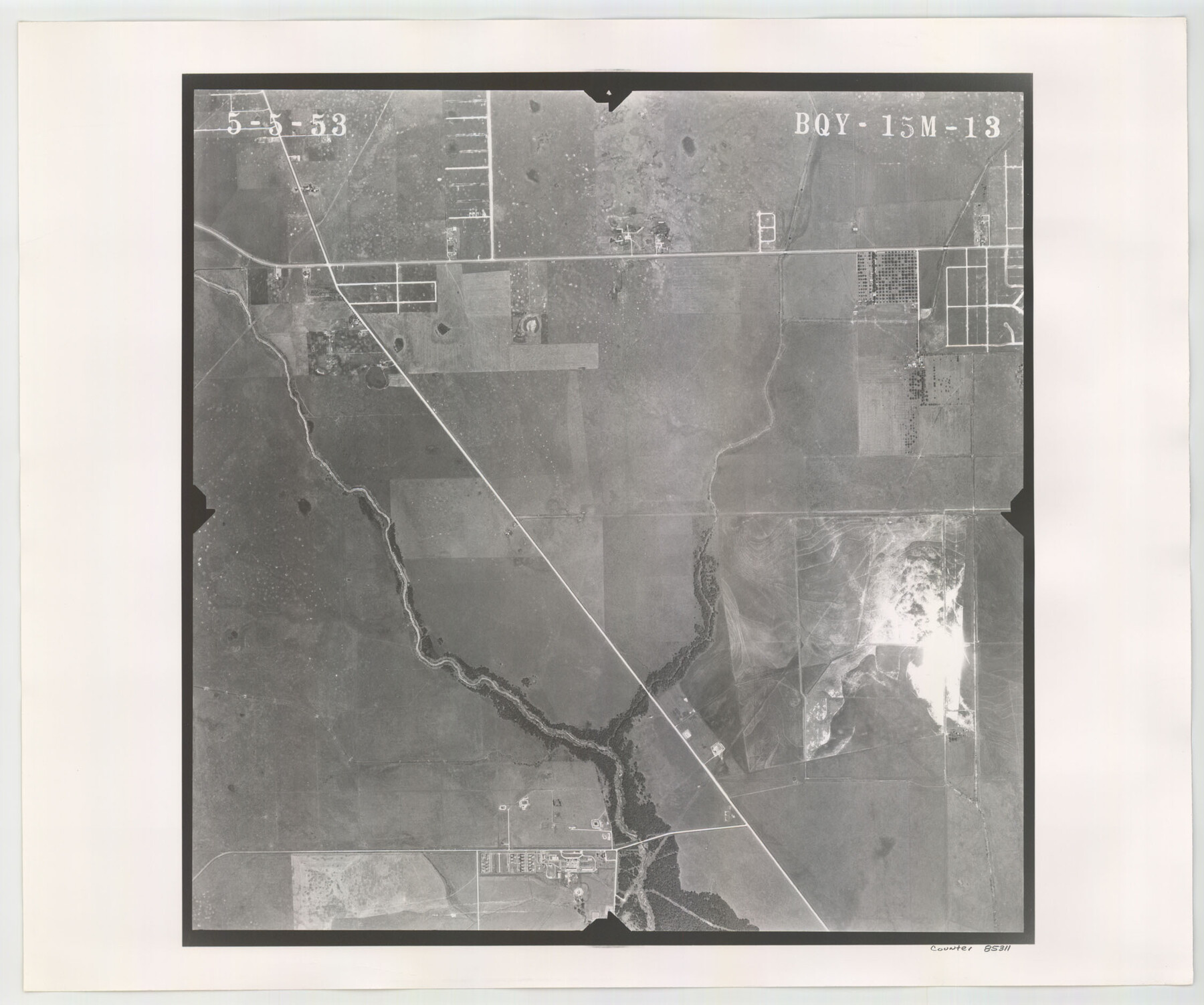
Flight Mission No. BQY-15M, Frame 13, Harris County
BQY-15M-13
-
Map/Doc
85311
-
Collection
General Map Collection
-
Object Dates
1953/5/5 (Creation Date)
-
People and Organizations
U. S. Department of Agriculture (Publisher)
-
Counties
Harris
-
Subjects
Aerial Photograph
-
Height x Width
18.8 x 22.5 inches
47.8 x 57.2 cm
-
Comments
Flown by Jack Ammann Photogrammetric Engineers of San Antonio, Texas.
Part of: General Map Collection
Parker County Working Sketch 19-1

Print $20.00
- Digital $50.00
Parker County Working Sketch 19-1
2004
Map/Doc 83579
Crosby County Sketch File 17

Print $4.00
- Digital $50.00
Crosby County Sketch File 17
1907
Size 4.2 x 8.9 inches
Map/Doc 20069
Somervell County Sketch File 3

Print $6.00
- Digital $50.00
Somervell County Sketch File 3
1858
Size 8.2 x 3.9 inches
Map/Doc 36797
Hunt County Sketch File 17

Print $8.00
- Digital $50.00
Hunt County Sketch File 17
1861
Size 10.6 x 8.2 inches
Map/Doc 27114
Coast Chart No. 212 - From Latitude 26° 33' to the Rio Grande Texas

Print $20.00
- Digital $50.00
Coast Chart No. 212 - From Latitude 26° 33' to the Rio Grande Texas
1886
Size 27.2 x 18.2 inches
Map/Doc 72830
Hidalgo County Sketch File 8

Print $4.00
- Digital $50.00
Hidalgo County Sketch File 8
1890
Size 14.1 x 8.6 inches
Map/Doc 26407
Foard County Sketch File 9

Print $20.00
- Digital $50.00
Foard County Sketch File 9
1882
Size 19.7 x 17.1 inches
Map/Doc 11492

Cameron County State Real Property Sketch 2

Print $20.00
- Digital $50.00
Cameron County State Real Property Sketch 2
1996
Size 25.4 x 39.1 inches
Map/Doc 80132
Edwards County Boundary File 27

Print $8.00
- Digital $50.00
Edwards County Boundary File 27
Size 8.8 x 3.9 inches
Map/Doc 52876
Floyd County Sketch File 12

Print $10.00
- Digital $50.00
Floyd County Sketch File 12
1913
Size 10.8 x 8.8 inches
Map/Doc 22708
Panola County Sketch File 18

Print $20.00
- Digital $50.00
Panola County Sketch File 18
1909
Size 24.2 x 18.7 inches
Map/Doc 12138
You may also like
Right of Way & Track Map, St. Louis, Brownsville & Mexico Ry. operated by St. Louis, Brownsville & Mexico Ry. Co.

Print $40.00
- Digital $50.00
Right of Way & Track Map, St. Louis, Brownsville & Mexico Ry. operated by St. Louis, Brownsville & Mexico Ry. Co.
1919
Size 25.4 x 56.9 inches
Map/Doc 64623
Maps & Lists Showing Prison Lands (Oil & Gas) Leased as of June 1955

Digital $50.00
Maps & Lists Showing Prison Lands (Oil & Gas) Leased as of June 1955
1930
Size 24.4 x 26.8 inches
Map/Doc 62876
Zapata County Working Sketch 11

Print $20.00
- Digital $50.00
Zapata County Working Sketch 11
1958
Size 38.1 x 28.7 inches
Map/Doc 62062
Nacogdoches County

Print $40.00
- Digital $50.00
Nacogdoches County
1950
Size 48.1 x 44.1 inches
Map/Doc 95598
Flight Mission No. BQR-3K, Frame 161, Brazoria County

Print $20.00
- Digital $50.00
Flight Mission No. BQR-3K, Frame 161, Brazoria County
1952
Size 18.7 x 22.4 inches
Map/Doc 83988
Crockett County Rolled Sketch 94

Print $40.00
- Digital $50.00
Crockett County Rolled Sketch 94
1979
Size 45.0 x 49.7 inches
Map/Doc 8738
Burnet County Working Sketch 7

Print $20.00
- Digital $50.00
Burnet County Working Sketch 7
1960
Size 17.9 x 20.3 inches
Map/Doc 67850
Midland County Working Sketch 6

Print $20.00
- Digital $50.00
Midland County Working Sketch 6
1950
Size 41.2 x 30.9 inches
Map/Doc 70986
Llano County Sketch File 16

Print $12.00
- Digital $50.00
Llano County Sketch File 16
1905
Size 12.3 x 11.3 inches
Map/Doc 30392
Donley County Sketch File 15a

Print $20.00
- Digital $50.00
Donley County Sketch File 15a
Size 16.8 x 27.1 inches
Map/Doc 11365
El Paso County Rolled Sketch 52

Print $20.00
- Digital $50.00
El Paso County Rolled Sketch 52
1929
Size 18.5 x 24.3 inches
Map/Doc 5849
