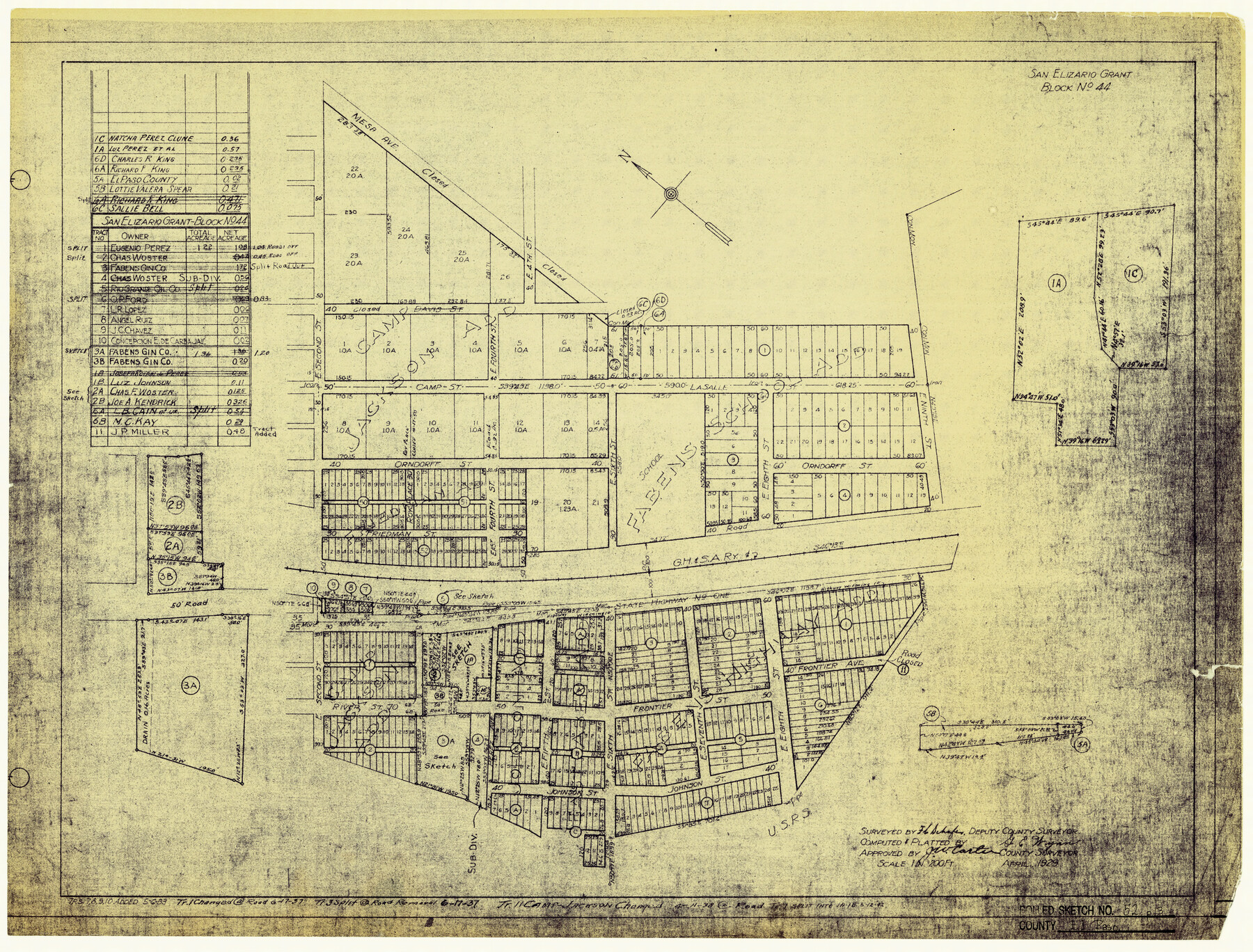
El Paso County Rolled Sketch 52
San Elizario Grant - Block No. 44
-
Map/Doc
5849
-
Collection
General Map Collection
-
Object Dates
4/1929 (Creation Date)
10/23/1974 (File Date)
-
People and Organizations
F.C. Schafer (Surveyor/Engineer)
J.W. Carter (Surveyor/Engineer)
G.E. Wynn (Draftsman)
-
Counties
El Paso
-
Subjects
Surveying Rolled Sketch
-
Height x Width
18.5 x 24.3 inches
47.0 x 61.7 cm
-
Medium
blueprint/diazo
-
Scale
1" = 200 feet
Part of: General Map Collection
McMullen County Sketch File 34

Print $25.00
- Digital $50.00
McMullen County Sketch File 34
Size 10.5 x 9.2 inches
Map/Doc 31400
A General Map of the Northern British Colonies in America which comprehends the Province of Quebec, the Government of Newfoundland, Nova-Scotia, New England and New York

Print $20.00
- Digital $50.00
A General Map of the Northern British Colonies in America which comprehends the Province of Quebec, the Government of Newfoundland, Nova-Scotia, New England and New York
1776
Size 21.3 x 27.3 inches
Map/Doc 97401
Edwards County Working Sketch 11

Print $20.00
- Digital $50.00
Edwards County Working Sketch 11
1922
Size 18.8 x 31.7 inches
Map/Doc 68887

Milam County Sketch File 8

Print $20.00
- Digital $50.00
Milam County Sketch File 8
1856
Size 16.8 x 33.7 inches
Map/Doc 12091
West and Trans-Pecos Texas with parts of New Mexico and Mexico and a New Map of Big Bend Ranch State Park and Surrounding Area

Print $32.48
West and Trans-Pecos Texas with parts of New Mexico and Mexico and a New Map of Big Bend Ranch State Park and Surrounding Area
1988
Size 28.0 x 31.0 inches
Map/Doc 89070
Right of Way and Track Map, Dayton-Goose Creek Ry. Co., Station 401+20 to Station 612+40
Print $40.00
- Digital $50.00
Right of Way and Track Map, Dayton-Goose Creek Ry. Co., Station 401+20 to Station 612+40
1917
Size 25.4 x 56.4 inches
Map/Doc 64367
[Sketch for Mineral Application 24072, San Jacinto River]
![65609, [Sketch for Mineral Application 24072, San Jacinto River], General Map Collection](https://historictexasmaps.com/wmedia_w700/maps/65609.tif.jpg)
Print $20.00
- Digital $50.00
[Sketch for Mineral Application 24072, San Jacinto River]
1929
Size 8.4 x 13.9 inches
Map/Doc 65609
Flight Mission No. DCL-6C, Frame 79, Kenedy County

Print $20.00
- Digital $50.00
Flight Mission No. DCL-6C, Frame 79, Kenedy County
1943
Size 18.6 x 22.4 inches
Map/Doc 85921
Map showing the location of the Pecos Valley Railway through H. &. G. N. R.R. Co. Land in Reeves Co., Texas

Print $20.00
- Digital $50.00
Map showing the location of the Pecos Valley Railway through H. &. G. N. R.R. Co. Land in Reeves Co., Texas
1891
Size 37.9 x 42.6 inches
Map/Doc 64708
Garza County Sketch File 15

Print $20.00
- Digital $50.00
Garza County Sketch File 15
1902
Size 16.8 x 14.7 inches
Map/Doc 11545
Winkler County Rolled Sketch 15

Print $20.00
- Digital $50.00
Winkler County Rolled Sketch 15
1968
Size 25.1 x 37.8 inches
Map/Doc 10305
You may also like
San Jacinto County Sketch File 7

Print $10.00
- Digital $50.00
San Jacinto County Sketch File 7
1848
Size 8.1 x 10.0 inches
Map/Doc 35705
Controlled Mosaic by Jack Amman Photogrammetric Engineers, Inc - Sheet 50

Print $20.00
- Digital $50.00
Controlled Mosaic by Jack Amman Photogrammetric Engineers, Inc - Sheet 50
1954
Size 20.0 x 24.0 inches
Map/Doc 83509
Double Lakes No. 1, T-Ranch

Print $20.00
- Digital $50.00
Double Lakes No. 1, T-Ranch
Size 37.1 x 34.0 inches
Map/Doc 92944
Irion County Rolled Sketch 25

Print $20.00
- Digital $50.00
Irion County Rolled Sketch 25
2008
Size 35.7 x 24.4 inches
Map/Doc 89227
Val Verde County Sketch File 50

Print $8.00
- Digital $50.00
Val Verde County Sketch File 50
1956
Size 11.5 x 8.9 inches
Map/Doc 39316
Calhoun County Rolled Sketch 26

Print $20.00
- Digital $50.00
Calhoun County Rolled Sketch 26
1941
Size 10.9 x 39.9 inches
Map/Doc 5374
Flight Mission No. BQR-22K, Frame 34, Brazoria County

Print $20.00
- Digital $50.00
Flight Mission No. BQR-22K, Frame 34, Brazoria County
1953
Size 18.7 x 22.5 inches
Map/Doc 84118
Flight Mission No. CRC-2R, Frame 201, Chambers County

Print $20.00
- Digital $50.00
Flight Mission No. CRC-2R, Frame 201, Chambers County
1956
Size 18.5 x 22.3 inches
Map/Doc 84779
Presidio County Rolled Sketch 13

Print $40.00
- Digital $50.00
Presidio County Rolled Sketch 13
1882
Size 58.8 x 48.0 inches
Map/Doc 9763
Trinity River, Irving Sheet

Print $4.00
- Digital $50.00
Trinity River, Irving Sheet
1925
Size 20.7 x 17.9 inches
Map/Doc 65212
Chambers County Working Sketch Graphic Index

Print $20.00
- Digital $50.00
Chambers County Working Sketch Graphic Index
1922
Size 39.3 x 47.3 inches
Map/Doc 76491
Stephens County Working Sketch 8

Print $20.00
- Digital $50.00
Stephens County Working Sketch 8
1920
Size 21.0 x 28.7 inches
Map/Doc 63951