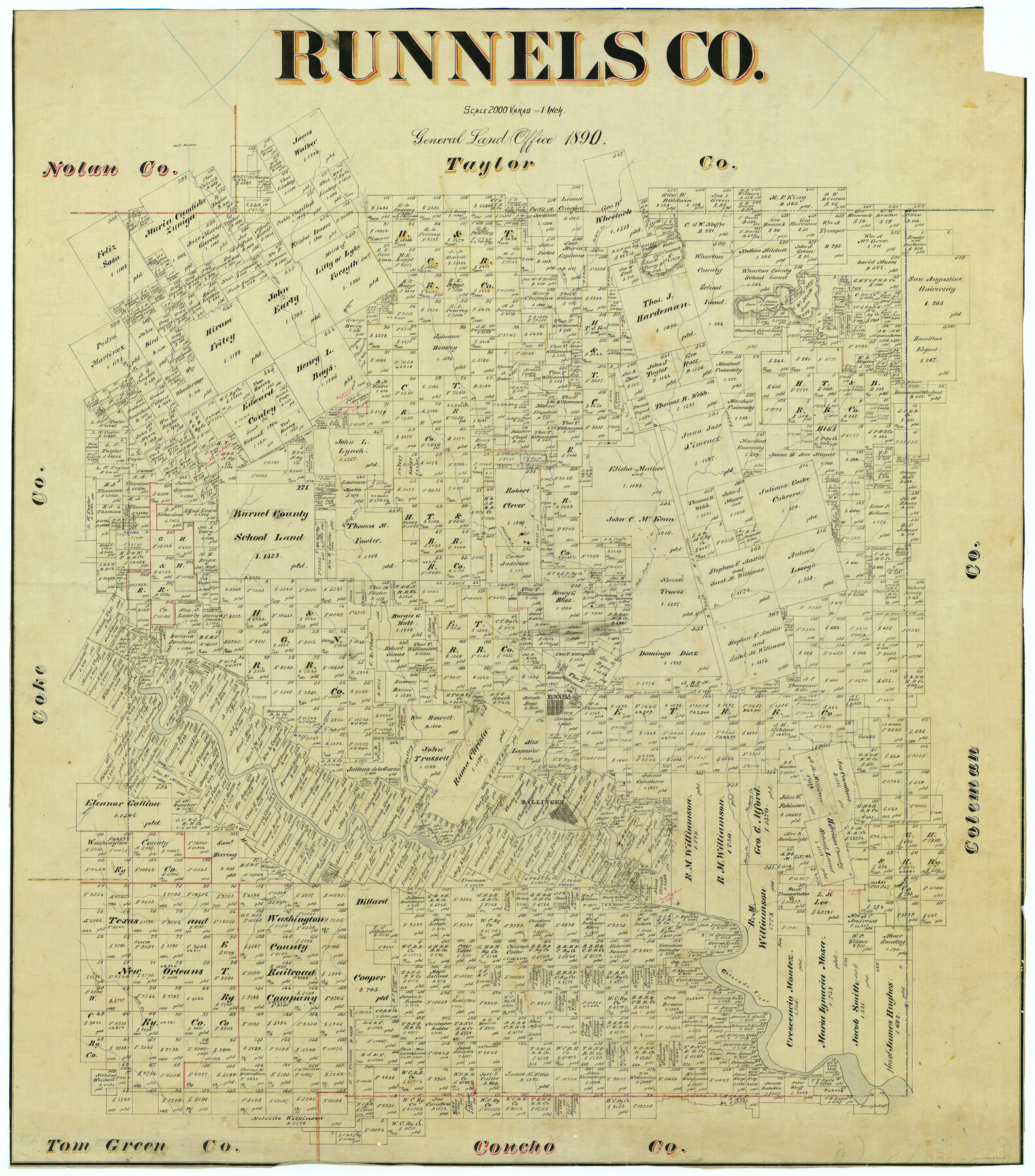
Runnels Co.
-
Map/Doc
63007
-
Collection
General Map Collection
-
Object Dates
1890 (Creation Date)
-
People and Organizations
Texas General Land Office (Publisher)
-
Counties
Runnels
-
Subjects
County
-
Height x Width
43.5 x 38.3 inches
110.5 x 97.3 cm
Part of: General Map Collection
Cameron County NRC Article 33.136 Location Key Sheet

Print $20.00
- Digital $50.00
Cameron County NRC Article 33.136 Location Key Sheet
1983
Size 27.0 x 22.0 inches
Map/Doc 77013
Liberty County Working Sketch 5

Print $20.00
- Digital $50.00
Liberty County Working Sketch 5
1901
Size 41.9 x 36.5 inches
Map/Doc 70464
Liberty County Working Sketch 71

Print $20.00
- Digital $50.00
Liberty County Working Sketch 71
1977
Size 37.3 x 31.8 inches
Map/Doc 70531
Van Zandt County Working Sketch 7

Print $20.00
- Digital $50.00
Van Zandt County Working Sketch 7
1953
Size 17.7 x 18.1 inches
Map/Doc 72257
Wise County Working Sketch 19

Print $20.00
- Digital $50.00
Wise County Working Sketch 19
1978
Size 28.6 x 32.5 inches
Map/Doc 72633
[Plat of Trinity River w/ Midstream Profile in Liberty County by US Government 1899]
![65335, [Plat of Trinity River w/ Midstream Profile in Liberty County by US Government 1899], General Map Collection](https://historictexasmaps.com/wmedia_w700/maps/65335.tif.jpg)
Print $20.00
- Digital $50.00
[Plat of Trinity River w/ Midstream Profile in Liberty County by US Government 1899]
1899
Size 11.5 x 18.3 inches
Map/Doc 65335
Kimble County Working Sketch 14

Print $20.00
- Digital $50.00
Kimble County Working Sketch 14
1923
Size 17.2 x 13.2 inches
Map/Doc 70082
Jeff Davis County Rolled Sketch 29

Print $20.00
- Digital $50.00
Jeff Davis County Rolled Sketch 29
Size 40.4 x 27.2 inches
Map/Doc 6377
Loving County

Print $20.00
- Digital $50.00
Loving County
1932
Size 35.0 x 45.6 inches
Map/Doc 73225
Galveston County Working Sketch 16

Print $20.00
- Digital $50.00
Galveston County Working Sketch 16
1980
Size 30.5 x 36.9 inches
Map/Doc 69353
Montgomery County Sketch File 17

Print $42.00
- Digital $50.00
Montgomery County Sketch File 17
1912
Size 8.6 x 7.8 inches
Map/Doc 31832
Tarrant County Sketch File 9

Print $4.00
- Digital $50.00
Tarrant County Sketch File 9
1858
Size 6.5 x 8.4 inches
Map/Doc 37689
You may also like
Hays County Working Sketch 17

Print $20.00
- Digital $50.00
Hays County Working Sketch 17
1971
Size 28.6 x 30.0 inches
Map/Doc 66091
Culberson County Rolled Sketch 19A
Print $20.00
- Digital $50.00
Culberson County Rolled Sketch 19A
Size 23.2 x 28.6 inches
Map/Doc 5652
Surveys in Austin's Colony along the east fork of Mill Creek

Print $20.00
- Digital $50.00
Surveys in Austin's Colony along the east fork of Mill Creek
1830
Size 23.7 x 12.6 inches
Map/Doc 208
Taylor County Working Sketch 21

Print $40.00
- Digital $50.00
Taylor County Working Sketch 21
1985
Size 55.9 x 43.8 inches
Map/Doc 69631
Flight Mission No. CGI-4N, Frame 163, Cameron County

Print $20.00
- Digital $50.00
Flight Mission No. CGI-4N, Frame 163, Cameron County
1955
Size 18.6 x 22.3 inches
Map/Doc 84671
Lavaca County Working Sketch 16

Print $20.00
- Digital $50.00
Lavaca County Working Sketch 16
1977
Size 25.0 x 24.9 inches
Map/Doc 70369
Sections 13 & 12, Block S

Print $20.00
- Digital $50.00
Sections 13 & 12, Block S
Size 23.0 x 18.2 inches
Map/Doc 92835
Cottle County Sketch File H

Print $12.00
- Digital $50.00
Cottle County Sketch File H
1976
Size 11.2 x 8.7 inches
Map/Doc 19451
Loving County Working Sketch 11

Print $40.00
- Digital $50.00
Loving County Working Sketch 11
1957
Size 21.2 x 120.7 inches
Map/Doc 70643
Flight Mission No. DCL-6C, Frame 16, Kenedy County

Print $20.00
- Digital $50.00
Flight Mission No. DCL-6C, Frame 16, Kenedy County
1943
Size 18.7 x 22.3 inches
Map/Doc 85873
[Nueces Bay Islands and Nesting Birds]
![60311, [Nueces Bay Islands and Nesting Birds], General Map Collection](https://historictexasmaps.com/wmedia_w700/maps/60311.tif.jpg)
Print $2.00
- Digital $50.00
[Nueces Bay Islands and Nesting Birds]
1940
Size 11.5 x 7.1 inches
Map/Doc 60311
General Highway Map. Detail of Cities and Towns in Jefferson County, Texas [Beaumont-Port Arthur vicinity]
![79145, General Highway Map. Detail of Cities and Towns in Jefferson County, Texas [Beaumont-Port Arthur vicinity], Texas State Library and Archives](https://historictexasmaps.com/wmedia_w700/maps/79145.tif.jpg)
Print $20.00
General Highway Map. Detail of Cities and Towns in Jefferson County, Texas [Beaumont-Port Arthur vicinity]
1940
Size 24.8 x 18.3 inches
Map/Doc 79145