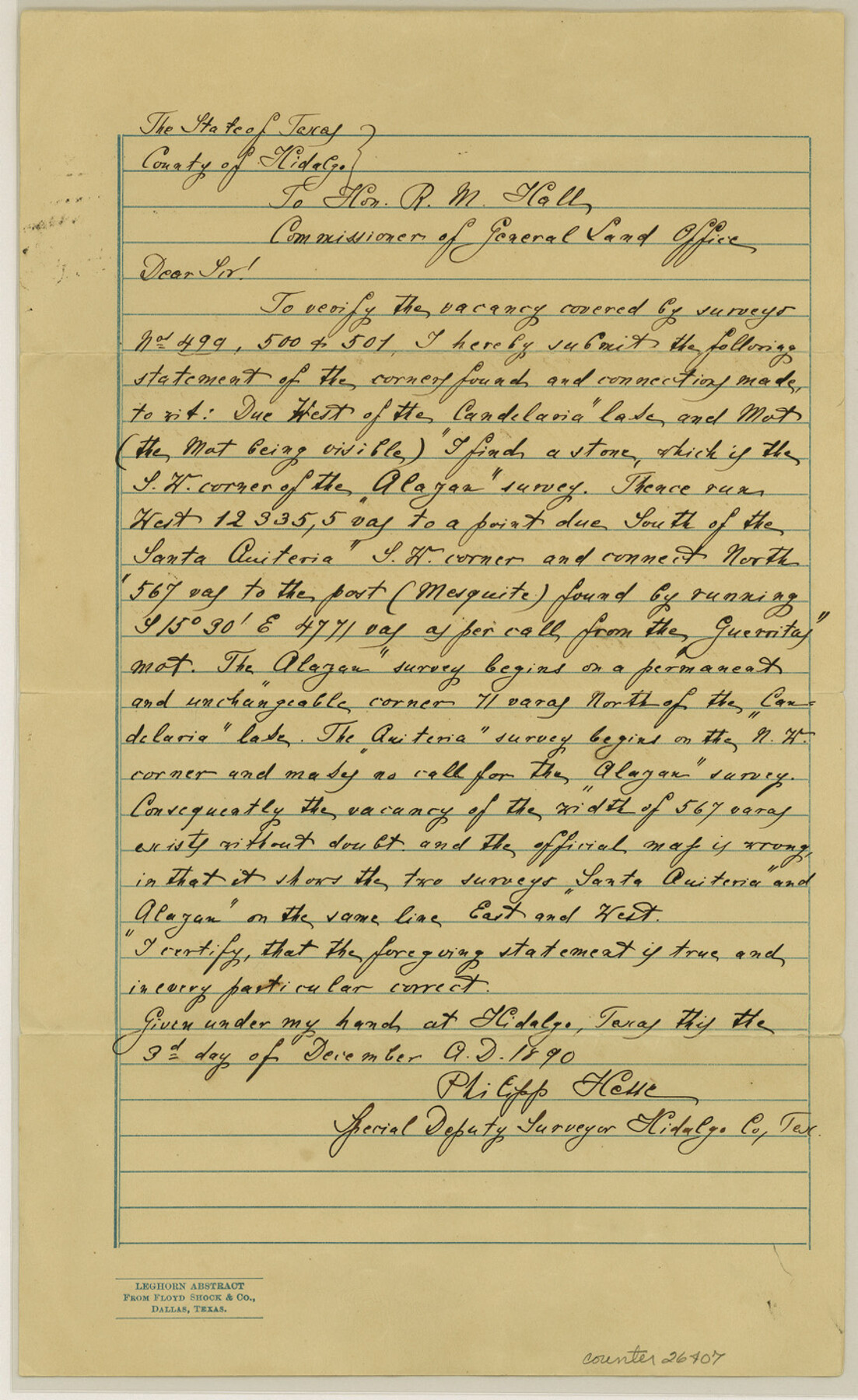
Hidalgo County Sketch File 8
[Statement of corners found and connections made to verify vacancy covered by surveys 499, 500 and 501]
-
Map/Doc
26407
-
Collection
General Map Collection
-
Object Dates
12/3/1890 (Creation Date)
12/15/1890 (File Date)
-
People and Organizations
Philipp Helle (Surveyor/Engineer)
-
Counties
Hidalgo Brooks Kenedy
-
Subjects
Surveying Sketch File
-
Height x Width
14.1 x 8.6 inches
35.8 x 21.8 cm
-
Medium
paper, manuscript
Part of: General Map Collection
Newton County Aerial Photograph Index Sheet 5

Print $20.00
- Digital $50.00
Newton County Aerial Photograph Index Sheet 5
1953
Size 24.1 x 17.7 inches
Map/Doc 83734
Terrell County Working Sketch 82

Print $20.00
- Digital $50.00
Terrell County Working Sketch 82
1991
Size 31.7 x 24.8 inches
Map/Doc 69603
Controlled Mosaic by Jack Amman Photogrammetric Engineers, Inc - Sheet 22

Print $20.00
- Digital $50.00
Controlled Mosaic by Jack Amman Photogrammetric Engineers, Inc - Sheet 22
1954
Size 20.0 x 24.0 inches
Map/Doc 83471
DeWitt County Boundary File 25 1/2

Print $34.00
- Digital $50.00
DeWitt County Boundary File 25 1/2
Size 8.5 x 4.0 inches
Map/Doc 52522
Cameron County Rolled Sketch 17

Print $40.00
- Digital $50.00
Cameron County Rolled Sketch 17
1937
Size 49.1 x 37.9 inches
Map/Doc 8570
Menard County Sketch File 10

Print $20.00
- Digital $50.00
Menard County Sketch File 10
1885
Size 32.5 x 18.0 inches
Map/Doc 12074
[Travis Station Map - Tracks and Structures - Lands. San Antonio & Aransas Pass Railway Co.]
![62564, [Travis Station Map - Tracks and Structures - Lands. San Antonio & Aransas Pass Railway Co.], General Map Collection](https://historictexasmaps.com/wmedia_w700/maps/62564.tif.jpg)
Print $4.00
- Digital $50.00
[Travis Station Map - Tracks and Structures - Lands. San Antonio & Aransas Pass Railway Co.]
1919
Size 11.7 x 18.7 inches
Map/Doc 62564
Flight Mission No. DQN-6K, Frame 4, Calhoun County

Print $20.00
- Digital $50.00
Flight Mission No. DQN-6K, Frame 4, Calhoun County
1953
Size 18.4 x 22.1 inches
Map/Doc 84426
Reeves County Boundary File 1

Print $12.00
- Digital $50.00
Reeves County Boundary File 1
Size 14.1 x 8.5 inches
Map/Doc 58195
Jeff Davis County Working Sketch 49

Print $20.00
- Digital $50.00
Jeff Davis County Working Sketch 49
2008
Size 38.0 x 35.7 inches
Map/Doc 88816
Flight Mission No. DQO-8K, Frame 21, Galveston County

Print $20.00
- Digital $50.00
Flight Mission No. DQO-8K, Frame 21, Galveston County
1952
Size 18.6 x 22.3 inches
Map/Doc 85144
International and Great Northern Railroad Lone Star Route and Connections

Print $20.00
- Digital $50.00
International and Great Northern Railroad Lone Star Route and Connections
1877
Size 17.3 x 23.2 inches
Map/Doc 93462
You may also like
San Jacinto County Working Sketch 38

Print $40.00
- Digital $50.00
San Jacinto County Working Sketch 38
1966
Size 41.5 x 55.9 inches
Map/Doc 63751
Falls County Sketch File 27

Print $6.00
- Digital $50.00
Falls County Sketch File 27
Size 16.1 x 11.0 inches
Map/Doc 22436
Flight Mission No. CUG-1P, Frame 26, Kleberg County

Print $20.00
- Digital $50.00
Flight Mission No. CUG-1P, Frame 26, Kleberg County
1956
Size 18.6 x 22.2 inches
Map/Doc 86116
Duval County Sketch File 48

Print $8.00
- Digital $50.00
Duval County Sketch File 48
1935
Size 14.2 x 8.8 inches
Map/Doc 21405
Duval County Rolled Sketch 27

Print $40.00
- Digital $50.00
Duval County Rolled Sketch 27
Size 14.6 x 50.6 inches
Map/Doc 8814
Maps of Gulf Intracoastal Waterway, Texas - Sabine River to the Rio Grande and connecting waterways including ship channels

Print $20.00
- Digital $50.00
Maps of Gulf Intracoastal Waterway, Texas - Sabine River to the Rio Grande and connecting waterways including ship channels
1966
Size 14.6 x 22.2 inches
Map/Doc 61955
Gaines County Rolled Sketch 27

Print $20.00
- Digital $50.00
Gaines County Rolled Sketch 27
1983
Size 35.6 x 41.8 inches
Map/Doc 9042
[Rio Grande & Eagle Pass - Stockdale to Cuero]
![64048, [Rio Grande & Eagle Pass - Stockdale to Cuero], General Map Collection](https://historictexasmaps.com/wmedia_w700/maps/64048.tif.jpg)
Print $40.00
- Digital $50.00
[Rio Grande & Eagle Pass - Stockdale to Cuero]
Size 19.9 x 122.5 inches
Map/Doc 64048
Kimble County Rolled Sketch 42

Print $20.00
- Digital $50.00
Kimble County Rolled Sketch 42
1995
Size 37.7 x 47.8 inches
Map/Doc 9341
Coryell County Working Sketch 2

Print $20.00
- Digital $50.00
Coryell County Working Sketch 2
1906
Size 15.3 x 18.5 inches
Map/Doc 68209
Montgomery County Sketch File 31

Print $20.00
- Digital $50.00
Montgomery County Sketch File 31
1932
Size 35.2 x 34.1 inches
Map/Doc 10550
