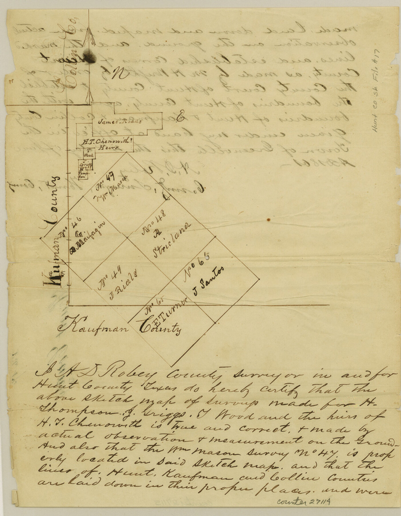
Hunt County Sketch File 17
[Sketch and explanation of county boundary lines]
-
Map/Doc
27114
-
Collection
General Map Collection
-
Object Dates
6/5/1861 (Creation Date)
7/10/1861 (File Date)
11/1846 (Survey Date)
-
People and Organizations
A.D. Robey (Surveyor/Engineer)
H. Wright (Surveyor/Engineer)
M. Quincy (Surveyor/Engineer)
-
Counties
Hunt Kaufman Rockwall
-
Subjects
Surveying Sketch File
-
Height x Width
10.6 x 8.2 inches
26.9 x 20.8 cm
-
Medium
paper, manuscript
Part of: General Map Collection
Flight Mission No. DQN-3K, Frame 8, Calhoun County

Print $20.00
- Digital $50.00
Flight Mission No. DQN-3K, Frame 8, Calhoun County
1953
Size 18.5 x 22.1 inches
Map/Doc 84340
W. M. Kuykendall Ranch, Matagorda County, Texas

Print $20.00
- Digital $50.00
W. M. Kuykendall Ranch, Matagorda County, Texas
1926
Size 24.3 x 39.6 inches
Map/Doc 3028
Hopkins County Sketch File 3

Print $4.00
- Digital $50.00
Hopkins County Sketch File 3
Size 10.0 x 8.1 inches
Map/Doc 26685
Flight Mission No. DCL-6C, Frame 126, Kenedy County

Print $20.00
- Digital $50.00
Flight Mission No. DCL-6C, Frame 126, Kenedy County
1943
Size 18.5 x 22.3 inches
Map/Doc 85956
Bee County Sketch File 1a

Print $12.00
- Digital $50.00
Bee County Sketch File 1a
1846
Size 9.8 x 6.5 inches
Map/Doc 14359
Edwards County Working Sketch 69

Print $20.00
- Digital $50.00
Edwards County Working Sketch 69
1957
Size 20.3 x 22.5 inches
Map/Doc 68945
Kinney County Sketch File 23

Print $40.00
- Digital $50.00
Kinney County Sketch File 23
1901
Size 17.6 x 15.3 inches
Map/Doc 29162
Lampasas County Boundary File 17

Print $27.00
- Digital $50.00
Lampasas County Boundary File 17
Size 7.2 x 8.8 inches
Map/Doc 56236
Hudspeth County Sketch File 13

Print $18.00
- Digital $50.00
Hudspeth County Sketch File 13
1915
Size 13.3 x 8.9 inches
Map/Doc 26929
Flight Mission No. CUG-3P, Frame 140, Kleberg County

Print $20.00
- Digital $50.00
Flight Mission No. CUG-3P, Frame 140, Kleberg County
1956
Size 18.7 x 22.3 inches
Map/Doc 86275
Mitchell's school atlas: comprising the maps, etc., designed to illustrate Mitchell's school and family geography

Print $370.00
- Digital $50.00
Mitchell's school atlas: comprising the maps, etc., designed to illustrate Mitchell's school and family geography
1851
Size 12.0 x 9.6 inches
Map/Doc 93491
El Paso County State Real Property Sketch 4

Print $20.00
- Digital $50.00
El Paso County State Real Property Sketch 4
2012
Size 29.9 x 35.9 inches
Map/Doc 93701
You may also like
Bee County Sketch File 2a

Print $6.00
- Digital $50.00
Bee County Sketch File 2a
1847
Size 7.9 x 13.0 inches
Map/Doc 14356
General Highway Map, Winkler County, Texas

Print $20.00
General Highway Map, Winkler County, Texas
1961
Size 18.2 x 24.8 inches
Map/Doc 79717
Freestone County Sketch File 12

Print $6.00
- Digital $50.00
Freestone County Sketch File 12
Size 8.2 x 6.3 inches
Map/Doc 23060
Armstrong County Rolled Sketch OS

Print $20.00
- Digital $50.00
Armstrong County Rolled Sketch OS
1902
Size 17.5 x 32.4 inches
Map/Doc 5086
Gonzales County Sketch File 5

Print $16.00
- Digital $50.00
Gonzales County Sketch File 5
1879
Size 10.0 x 8.1 inches
Map/Doc 24377
Wilbarger County Working Sketch 8

Print $20.00
- Digital $50.00
Wilbarger County Working Sketch 8
1948
Size 31.8 x 38.2 inches
Map/Doc 72546
Galveston Bay and Approaches

Print $20.00
- Digital $50.00
Galveston Bay and Approaches
1938
Size 45.4 x 34.6 inches
Map/Doc 69875
Map of France, Spain, Portugal and Italy engraved to illustrate Mitchell's school and family geography (Inset: Greece and the Ionian Islands)

Print $20.00
- Digital $50.00
Map of France, Spain, Portugal and Italy engraved to illustrate Mitchell's school and family geography (Inset: Greece and the Ionian Islands)
1846
Size 9.5 x 11.8 inches
Map/Doc 93505
Potter County Sketch File 11

Print $4.00
- Digital $50.00
Potter County Sketch File 11
1890
Size 14.0 x 8.8 inches
Map/Doc 34397
Harris County Rolled Sketch 62

Print $20.00
- Digital $50.00
Harris County Rolled Sketch 62
1930
Size 29.9 x 28.7 inches
Map/Doc 6108
[Blocks T2 and T3]
![90992, [Blocks T2 and T3], Twichell Survey Records](https://historictexasmaps.com/wmedia_w700/maps/90992-1.tif.jpg)
Print $20.00
- Digital $50.00
[Blocks T2 and T3]
Size 12.2 x 14.6 inches
Map/Doc 90992
Coleman County Working Sketch 22
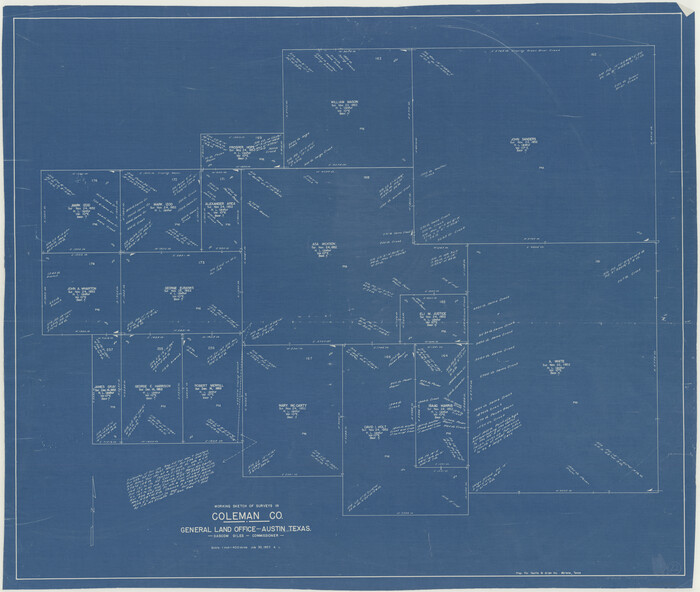
Print $20.00
- Digital $50.00
Coleman County Working Sketch 22
1953
Size 34.6 x 41.0 inches
Map/Doc 68088