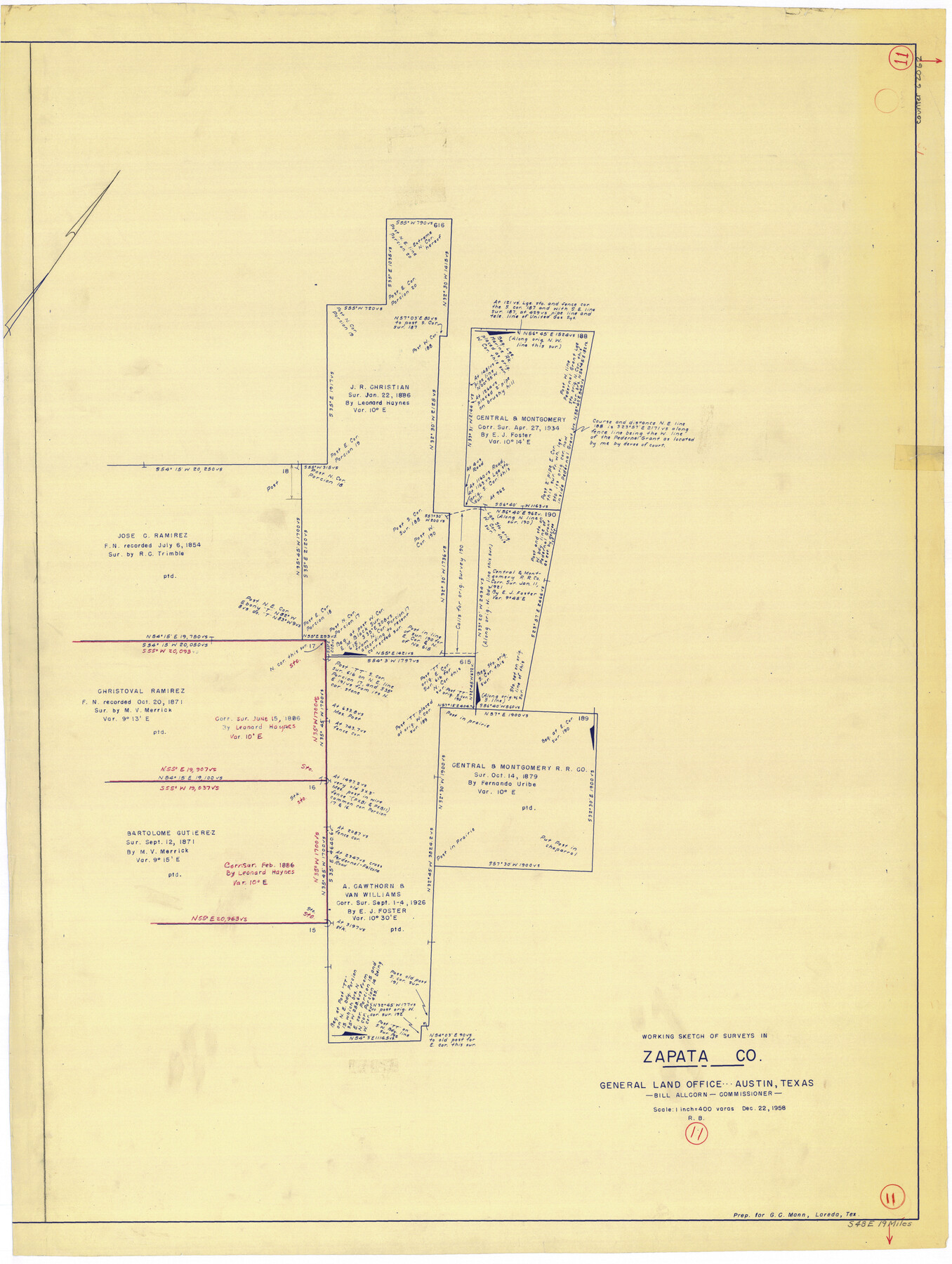
Zapata County Working Sketch 11
-
Map/Doc
62062
-
Collection
General Map Collection
-
Object Dates
12/22/1958 (Creation Date)
-
People and Organizations
Roy Buckholts (Draftsman)
-
Counties
Zapata
-
Subjects
Surveying Working Sketch
-
Height x Width
38.1 x 28.7 inches
96.8 x 72.9 cm
-
Scale
1" = 400 varas
Part of: General Map Collection
Nueces County Rolled Sketch 58

Print $50.00
Nueces County Rolled Sketch 58
1979
Size 28.2 x 40.1 inches
Map/Doc 6899
Intracoastal Waterway, Houma, LA to Corpus Christi, TX

Print $5.00
- Digital $50.00
Intracoastal Waterway, Houma, LA to Corpus Christi, TX
Size 29.3 x 22.0 inches
Map/Doc 61909
Greer County Sketch File 11

Print $6.00
- Digital $50.00
Greer County Sketch File 11
Size 14.2 x 8.8 inches
Map/Doc 24532

Johnson County Working Sketch 8

Print $20.00
- Digital $50.00
Johnson County Working Sketch 8
1952
Size 20.0 x 17.3 inches
Map/Doc 66621

Ochiltree County Sketch File 12

Print $24.00
- Digital $50.00
Ochiltree County Sketch File 12
1990
Size 11.2 x 8.5 inches
Map/Doc 33201
Denton County Working Sketch 30

Print $20.00
- Digital $50.00
Denton County Working Sketch 30
1999
Size 23.2 x 30.4 inches
Map/Doc 68635
[Sketch for Mineral Application 24072, San Jacinto River]
![65606, [Sketch for Mineral Application 24072, San Jacinto River], General Map Collection](https://historictexasmaps.com/wmedia_w700/maps/65606.tif.jpg)
Print $20.00
- Digital $50.00
[Sketch for Mineral Application 24072, San Jacinto River]
1929
Size 23.2 x 17.8 inches
Map/Doc 65606
Map of Main Line Houston & Tex. Centr. Railway from Dallas to Red River City

Print $40.00
- Digital $50.00
Map of Main Line Houston & Tex. Centr. Railway from Dallas to Red River City
Size 37.1 x 84.9 inches
Map/Doc 64089
Winkler County Working Sketch 3

Print $40.00
- Digital $50.00
Winkler County Working Sketch 3
1944
Size 43.5 x 60.5 inches
Map/Doc 72597
Liberty County Sketch File 5b

Print $6.00
- Digital $50.00
Liberty County Sketch File 5b
1857
Size 8.0 x 3.5 inches
Map/Doc 29890
You may also like
Panola County Rolled Sketch 7

Print $20.00
- Digital $50.00
Panola County Rolled Sketch 7
Size 18.6 x 23.4 inches
Map/Doc 7200
El Paso County Working Sketch 42

Print $20.00
- Digital $50.00
El Paso County Working Sketch 42
Size 24.6 x 26.6 inches
Map/Doc 69064
Terry County Rolled Sketch 7

Print $20.00
- Digital $50.00
Terry County Rolled Sketch 7
1903
Size 19.6 x 19.9 inches
Map/Doc 7981
Flight Mission No. DQN-5K, Frame 74, Calhoun County

Print $20.00
- Digital $50.00
Flight Mission No. DQN-5K, Frame 74, Calhoun County
1953
Size 18.5 x 22.2 inches
Map/Doc 84407
Dawson County Working Sketch Graphic Index

Print $20.00
- Digital $50.00
Dawson County Working Sketch Graphic Index
1959
Size 40.7 x 33.4 inches
Map/Doc 76518
Dallam County Sketch File 3

Print $4.00
- Digital $50.00
Dallam County Sketch File 3
Size 14.6 x 9.0 inches
Map/Doc 20337
In the Supreme Court of the United States The State of Oklahoma, Complainant vs. The State of Texas, Defendant, The United States of America, Intervener - 1920

Print $20.00
- Digital $50.00
In the Supreme Court of the United States The State of Oklahoma, Complainant vs. The State of Texas, Defendant, The United States of America, Intervener - 1920
1920
Size 32.4 x 36.8 inches
Map/Doc 75129
Flight Mission No. DCL-6C, Frame 139, Kenedy County

Print $20.00
- Digital $50.00
Flight Mission No. DCL-6C, Frame 139, Kenedy County
1943
Size 18.7 x 22.3 inches
Map/Doc 85965
Flight Mission No. BRA-3M, Frame 201, Jefferson County

Print $20.00
- Digital $50.00
Flight Mission No. BRA-3M, Frame 201, Jefferson County
1953
Size 18.7 x 22.5 inches
Map/Doc 85416
The Chief Justice County of Mina. Lands in Conflict with Colorado County

Print $20.00
The Chief Justice County of Mina. Lands in Conflict with Colorado County
2020
Size 15.8 x 21.7 inches
Map/Doc 96062
Flight Mission No. CRK-3P, Frame 62, Refugio County

Print $20.00
- Digital $50.00
Flight Mission No. CRK-3P, Frame 62, Refugio County
1956
Size 18.6 x 22.6 inches
Map/Doc 86904
Jefferson County Sketch File 42

Print $20.00
- Digital $50.00
Jefferson County Sketch File 42
1945
Size 25.5 x 35.1 inches
Map/Doc 11876