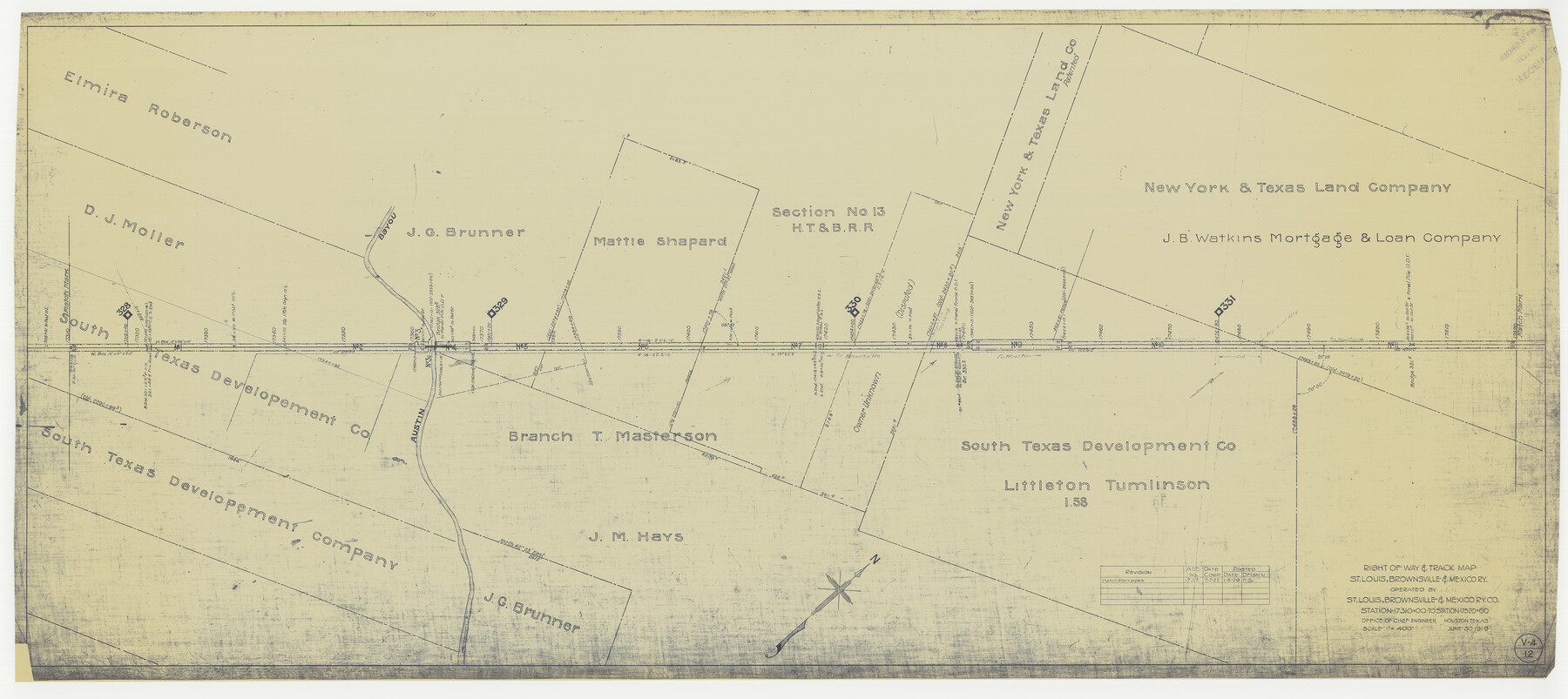
Right of Way & Track Map, St. Louis, Brownsville & Mexico Ry. operated by St. Louis, Brownsville & Mexico Ry. Co.
Station 17310+00 to Station 17520+00
Z-2-183
-
Map/Doc
64623
-
Collection
General Map Collection
-
Object Dates
1919/6/30 (Creation Date)
-
Counties
Brazoria
-
Subjects
Railroads
-
Height x Width
25.4 x 56.9 inches
64.5 x 144.5 cm
-
Medium
blueprint/diazo
-
Scale
1" = 400 feet
-
Comments
Jefferson Lake Oil Company.
See counter nos. 64612 through 64622 and 64624 through 64626 for other sheets. -
Features
SLB&M
[Railroad line] to Brownsville
[Railroad line] to Houston
Austin Bayou
Part of: General Map Collection
Carta General de la República Mexicana Formada en vista de los datos mas recientes y exactos que se han reunido con tal objeto, y constan en la noticia presentada al Exmo. Sr. Ministro de Fomento, por Antonio García y Cubas

Print $20.00
- Digital $50.00
Carta General de la República Mexicana Formada en vista de los datos mas recientes y exactos que se han reunido con tal objeto, y constan en la noticia presentada al Exmo. Sr. Ministro de Fomento, por Antonio García y Cubas
Size 23.3 x 29.2 inches
Map/Doc 95824
Map of Cass Co.

Print $20.00
- Digital $50.00
Map of Cass Co.
1862
Size 17.8 x 19.6 inches
Map/Doc 3372
Flight Mission No. CRC-4R, Frame 76, Chambers County

Print $20.00
- Digital $50.00
Flight Mission No. CRC-4R, Frame 76, Chambers County
1956
Size 18.8 x 22.4 inches
Map/Doc 84880
Flight Mission No. DQO-8K, Frame 85, Galveston County

Print $20.00
- Digital $50.00
Flight Mission No. DQO-8K, Frame 85, Galveston County
1952
Size 18.7 x 22.5 inches
Map/Doc 85187
[Copied from a chart of Galveston Bar and Harbor]
![72760, [Copied from a chart of Galveston Bar and Harbor], General Map Collection](https://historictexasmaps.com/wmedia_w700/maps/72760.tif.jpg)
Print $20.00
- Digital $50.00
[Copied from a chart of Galveston Bar and Harbor]
1846
Size 18.3 x 25.3 inches
Map/Doc 72760
Parker County Sketch File 26

Print $4.00
- Digital $50.00
Parker County Sketch File 26
1877
Size 14.3 x 9.0 inches
Map/Doc 33566
Supreme Court of the United States, October Term, 1924, No. 13, Original - The State of Oklahoma, Complainant vs. The State of Texas, Defendant, The United States, Intervener

Print $20.00
- Digital $50.00
Supreme Court of the United States, October Term, 1924, No. 13, Original - The State of Oklahoma, Complainant vs. The State of Texas, Defendant, The United States, Intervener
1924
Size 33.7 x 33.7 inches
Map/Doc 75119
The Coast of Mexico from Laguna de Esmotes to Punta Brava

Print $20.00
- Digital $50.00
The Coast of Mexico from Laguna de Esmotes to Punta Brava
Size 22.2 x 29.8 inches
Map/Doc 95920
Flight Mission No. CLL-4N, Frame 38, Willacy County

Print $20.00
- Digital $50.00
Flight Mission No. CLL-4N, Frame 38, Willacy County
1954
Size 18.4 x 22.1 inches
Map/Doc 87111

Coke County Rolled Sketch 3

Print $20.00
- Digital $50.00
Coke County Rolled Sketch 3
1947
Size 40.6 x 40.3 inches
Map/Doc 8623
Matagorda Light to Aransas Pass

Print $20.00
- Digital $50.00
Matagorda Light to Aransas Pass
1974
Size 36.5 x 45.3 inches
Map/Doc 73401
You may also like
Cass County Working Sketch 52

Print $20.00
- Digital $50.00
Cass County Working Sketch 52
2001
Size 32.9 x 23.9 inches
Map/Doc 67955
Limestone County Sketch File 10b

Print $22.00
- Digital $50.00
Limestone County Sketch File 10b
1875
Size 15.0 x 14.1 inches
Map/Doc 30175
Kinney County Working Sketch 3

Print $20.00
- Digital $50.00
Kinney County Working Sketch 3
Size 20.3 x 17.6 inches
Map/Doc 70185
Trinity County Sketch File 16

Print $4.00
- Digital $50.00
Trinity County Sketch File 16
1879
Size 8.2 x 11.1 inches
Map/Doc 38544
Flight Mission No. DQO-8K, Frame 76, Galveston County

Print $20.00
- Digital $50.00
Flight Mission No. DQO-8K, Frame 76, Galveston County
1952
Size 18.6 x 22.5 inches
Map/Doc 85180

Matagorda County Sketch File 23

Print $4.00
- Digital $50.00
Matagorda County Sketch File 23
1898
Size 14.2 x 8.6 inches
Map/Doc 30785

Leon County Working Sketch 34

Print $20.00
- Digital $50.00
Leon County Working Sketch 34
1978
Size 45.1 x 41.9 inches
Map/Doc 70433
Montgomery County Working Sketch 54

Print $20.00
- Digital $50.00
Montgomery County Working Sketch 54
1961
Size 30.6 x 28.3 inches
Map/Doc 71161
Starr County Boundary File 1

Print $24.00
- Digital $50.00
Starr County Boundary File 1
Size 13.0 x 8.5 inches
Map/Doc 58801
[Various County School Land Leagues]
![89849, [Various County School Land Leagues], Twichell Survey Records](https://historictexasmaps.com/wmedia_w700/maps/89849-1.tif.jpg)
Print $40.00
- Digital $50.00
[Various County School Land Leagues]
Size 55.7 x 41.4 inches
Map/Doc 89849