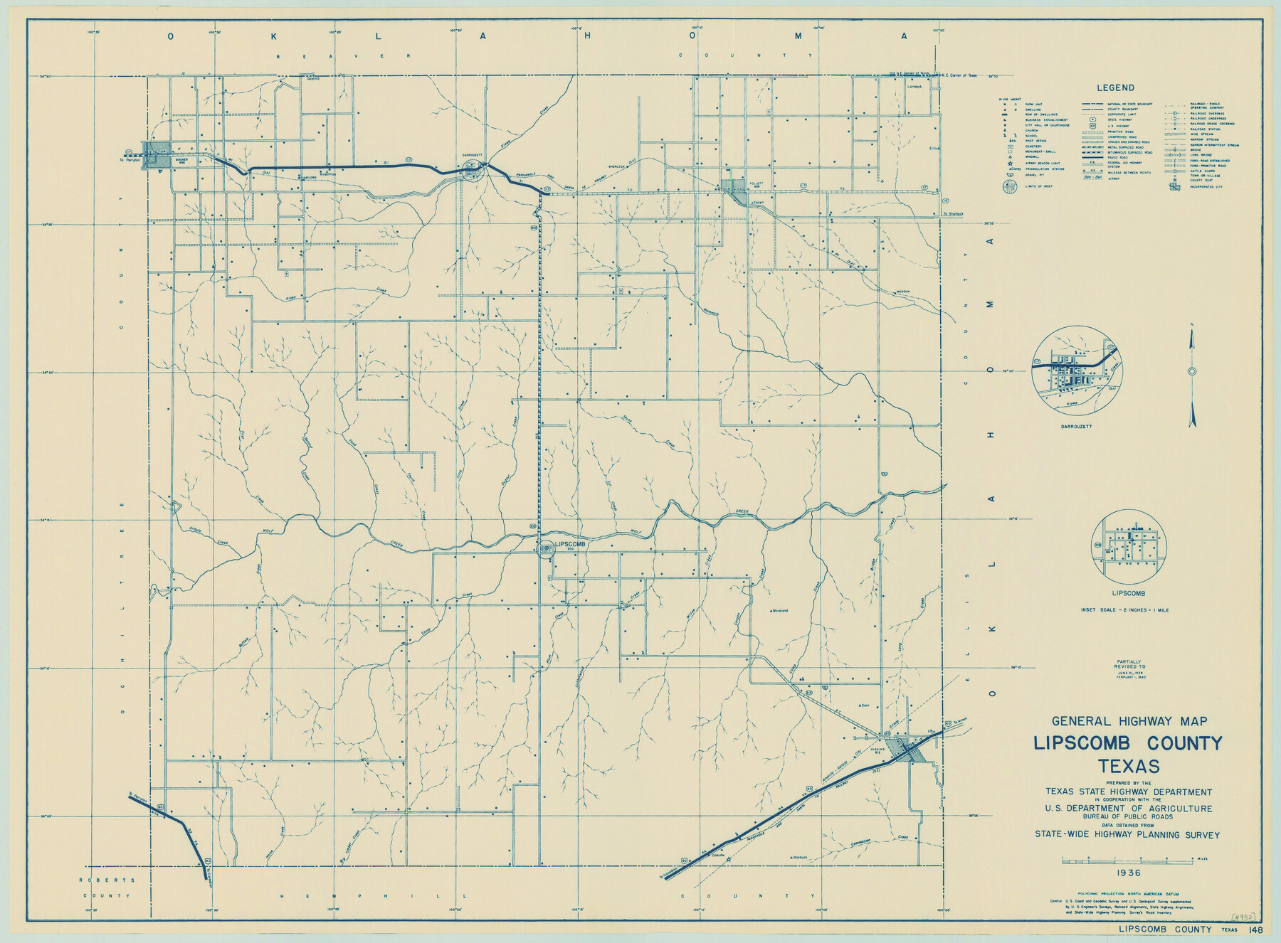
General Highway Map, Lipscomb County, Texas
-
Map/Doc
79175
-
Collection
Texas State Library and Archives
-
Object Dates
1940 (Creation Date)
-
People and Organizations
Texas State Highway Department (Publisher)
-
Counties
Lipscomb
-
Subjects
County
-
Height x Width
18.2 x 24.7 inches
46.2 x 62.7 cm
-
Comments
Prints available courtesy of the Texas State Library and Archives.
More info can be found here: TSLAC Map 04932
Part of: Texas State Library and Archives
General Highway Map, Callahan County, Texas

Print $20.00
General Highway Map, Callahan County, Texas
1940
Size 25.3 x 18.4 inches
Map/Doc 79037
General Highway Map, Houston County, Texas

Print $20.00
General Highway Map, Houston County, Texas
1940
Size 25.0 x 18.6 inches
Map/Doc 79132
General Highway Map, Wharton County, Texas

Print $20.00
General Highway Map, Wharton County, Texas
1961
Size 18.3 x 24.7 inches
Map/Doc 79706
General Highway Map, Concho County, Texas

Print $20.00
General Highway Map, Concho County, Texas
1961
Size 24.6 x 18.3 inches
Map/Doc 79420
General Highway Map, Castro County, Texas

Print $20.00
General Highway Map, Castro County, Texas
1940
Size 18.5 x 25.1 inches
Map/Doc 79043
General Highway Map, McCulloch County, Texas

Print $20.00
General Highway Map, McCulloch County, Texas
1961
Size 25.0 x 19.3 inches
Map/Doc 79588
General Highway Map, Coleman County, Texas

Print $20.00
General Highway Map, Coleman County, Texas
1940
Size 18.4 x 25.2 inches
Map/Doc 79050
General Highway Map, Loving County, Texas

Print $20.00
General Highway Map, Loving County, Texas
1940
Size 18.3 x 24.8 inches
Map/Doc 79179
General Highway Map. Detail of Cities and Towns in Hardin County, Texas [Silsbee and vicinity]
![79500, General Highway Map. Detail of Cities and Towns in Hardin County, Texas [Silsbee and vicinity], Texas State Library and Archives](https://historictexasmaps.com/wmedia_w700/maps/79500.tif.jpg)
Print $20.00
General Highway Map. Detail of Cities and Towns in Hardin County, Texas [Silsbee and vicinity]
1961
Size 18.1 x 24.7 inches
Map/Doc 79500
General Highway Map, Lamar County, Texas

Print $20.00
General Highway Map, Lamar County, Texas
1940
Size 24.8 x 18.5 inches
Map/Doc 79167
General Highway Map. Detail of Cities and Towns in Falls County, Texas

Print $20.00
General Highway Map. Detail of Cities and Towns in Falls County, Texas
1961
Size 18.1 x 24.4 inches
Map/Doc 79463

You may also like
Knox County Boundary File 1a

Print $16.00
- Digital $50.00
Knox County Boundary File 1a
Size 9.7 x 13.8 inches
Map/Doc 65010
[Surveys between Upper Keechi Creek and the Trinity River]
![293, [Surveys between Upper Keechi Creek and the Trinity River], General Map Collection](https://historictexasmaps.com/wmedia_w700/maps/293.tif.jpg)
Print $2.00
- Digital $50.00
[Surveys between Upper Keechi Creek and the Trinity River]
Size 8.5 x 6.9 inches
Map/Doc 293
Sketch from the map of Bailey Co.

Print $2.00
- Digital $50.00
Sketch from the map of Bailey Co.
Size 8.4 x 7.6 inches
Map/Doc 464
Polk County Working Sketch 38

Print $20.00
- Digital $50.00
Polk County Working Sketch 38
1975
Size 25.4 x 23.5 inches
Map/Doc 71655
Liberty County Rolled Sketch K

Print $40.00
- Digital $50.00
Liberty County Rolled Sketch K
1946
Size 35.3 x 54.7 inches
Map/Doc 10647
Flight Mission No. DCL-7C, Frame 61, Kenedy County

Print $20.00
- Digital $50.00
Flight Mission No. DCL-7C, Frame 61, Kenedy County
1943
Size 15.4 x 15.2 inches
Map/Doc 86049
Flight Mission No. DQO-2K, Frame 133, Galveston County

Print $20.00
- Digital $50.00
Flight Mission No. DQO-2K, Frame 133, Galveston County
1952
Size 18.7 x 22.5 inches
Map/Doc 85030
Live Oak County Working Sketch 23

Print $40.00
- Digital $50.00
Live Oak County Working Sketch 23
1976
Size 68.2 x 43.5 inches
Map/Doc 70608
Culberson County Rolled Sketch 29

Print $20.00
- Digital $50.00
Culberson County Rolled Sketch 29
Size 44.3 x 21.4 inches
Map/Doc 8745
Sabine Pass and Lake

Print $20.00
- Digital $50.00
Sabine Pass and Lake
1971
Size 47.0 x 27.5 inches
Map/Doc 69825
Flight Mission No. DIX-6P, Frame 113, Aransas County

Print $20.00
- Digital $50.00
Flight Mission No. DIX-6P, Frame 113, Aransas County
1956
Size 18.8 x 22.4 inches
Map/Doc 83819
Texas Gulf Coast, from the Sabine River to the Rio Grande as Subdivided for Mineral Development; Galveston, Brazoria and Matagorda Counties

Print $40.00
- Digital $50.00
Texas Gulf Coast, from the Sabine River to the Rio Grande as Subdivided for Mineral Development; Galveston, Brazoria and Matagorda Counties
1976
Size 43.8 x 69.3 inches
Map/Doc 1938