Liberty County Rolled Sketch K
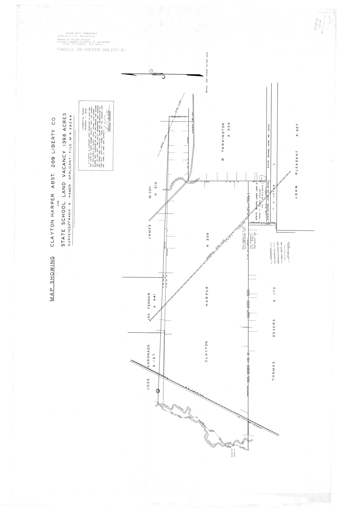
Map showing Clayton Harper abst. 209, Liberty Co. and state School Land vacancy 139.6 acres surveyed for Frank A. Hamer, applicant, file MA-38244
-
Map/Doc
10647
-
Collection
General Map Collection
-
Object Dates
1/1/1946 (Creation Date)
3/20/1946 (File Date)
-
People and Organizations
S.T. Coats (Surveyor/Engineer)
-
Counties
Liberty
-
Subjects
Surveying Rolled Sketch
-
Height x Width
35.3 x 54.7 inches
89.7 x 138.9 cm
-
Scale
1" = 300 varas
Part of: General Map Collection
Childress Co.

Print $20.00
- Digital $50.00
Childress Co.
1978
Size 46.2 x 35.0 inches
Map/Doc 73105
Limestone County Sketch File 7

Print $4.00
- Digital $50.00
Limestone County Sketch File 7
1862
Size 13.3 x 7.9 inches
Map/Doc 30169
Bee County Working Sketch 18

Print $20.00
- Digital $50.00
Bee County Working Sketch 18
1980
Size 19.5 x 18.5 inches
Map/Doc 67268
[Right of Way & Track Map, The Texas & Pacific Ry. Co. Main Line]
![64675, [Right of Way & Track Map, The Texas & Pacific Ry. Co. Main Line], General Map Collection](https://historictexasmaps.com/wmedia_w700/maps/64675.tif.jpg)
Print $20.00
- Digital $50.00
[Right of Way & Track Map, The Texas & Pacific Ry. Co. Main Line]
Size 11.0 x 18.4 inches
Map/Doc 64675
Flight Mission No. BRA-16M, Frame 142, Jefferson County

Print $20.00
- Digital $50.00
Flight Mission No. BRA-16M, Frame 142, Jefferson County
1953
Size 18.5 x 22.2 inches
Map/Doc 85748

Map of the Houston & Great Northern Railroad

Print $40.00
- Digital $50.00
Map of the Houston & Great Northern Railroad
1871
Size 26.2 x 87.5 inches
Map/Doc 64471
Map of City of Fort Worth, Texas

Print $20.00
- Digital $50.00
Map of City of Fort Worth, Texas
1934
Size 32.9 x 39.2 inches
Map/Doc 4839
Rains County Working Sketch 2

Print $20.00
- Digital $50.00
Rains County Working Sketch 2
Size 14.0 x 12.2 inches
Map/Doc 71828
Map of Panama, Texas

Print $5.00
- Digital $50.00
Map of Panama, Texas
1908
Size 10.4 x 15.6 inches
Map/Doc 94104
Winkler County

Print $20.00
- Digital $50.00
Winkler County
1890
Size 22.8 x 18.5 inches
Map/Doc 4160
Coleman County Working Sketch 5

Print $20.00
- Digital $50.00
Coleman County Working Sketch 5
1928
Size 27.0 x 25.6 inches
Map/Doc 68071
You may also like
Flight Mission No. CGI-4N, Frame 173, Cameron County

Print $20.00
- Digital $50.00
Flight Mission No. CGI-4N, Frame 173, Cameron County
1955
Size 18.6 x 22.3 inches
Map/Doc 84676
Duval County Working Sketch 58

Print $20.00
- Digital $50.00
Duval County Working Sketch 58
Size 21.0 x 33.0 inches
Map/Doc 67498
The Coast of Texas

Print $20.00
- Digital $50.00
The Coast of Texas
1844
Size 18.2 x 27.0 inches
Map/Doc 72700
Rockwall County

Print $20.00
- Digital $50.00
Rockwall County
1941
Size 29.7 x 24.1 inches
Map/Doc 95628
Geographical, Statistical, and Historical Map of Arkansas Territory

Print $20.00
- Digital $50.00
Geographical, Statistical, and Historical Map of Arkansas Territory
Size 17.9 x 21.9 inches
Map/Doc 95713
Harris County Rolled Sketch 80B

Print $20.00
- Digital $50.00
Harris County Rolled Sketch 80B
Size 32.0 x 44.2 inches
Map/Doc 9137
[Del Rio, Texas]
![2070, [Del Rio, Texas], General Map Collection](https://historictexasmaps.com/wmedia_w700/maps/2070-1.tif.jpg)
Print $20.00
- Digital $50.00
[Del Rio, Texas]
1886
Size 24.2 x 34.3 inches
Map/Doc 2070
Hardin County Sketch File 58

Print $6.00
- Digital $50.00
Hardin County Sketch File 58
1929
Size 14.3 x 11.5 inches
Map/Doc 25230
Henderson County Sketch File 16

Print $40.00
- Digital $50.00
Henderson County Sketch File 16
1935
Size 14.9 x 16.3 inches
Map/Doc 26359
Castro County Rolled Sketch 14

Print $20.00
- Digital $50.00
Castro County Rolled Sketch 14
1965
Size 47.6 x 43.5 inches
Map/Doc 8608
Hardeman Co[unty]
![16845, Hardeman Co[unty], General Map Collection](https://historictexasmaps.com/wmedia_w700/maps/16845.tif.jpg)
Print $40.00
- Digital $50.00
Hardeman Co[unty]
1886
Size 60.7 x 48.8 inches
Map/Doc 16845
Jefferson County Sketch File 17

Print $4.00
- Digital $50.00
Jefferson County Sketch File 17
Size 7.9 x 8.1 inches
Map/Doc 28165