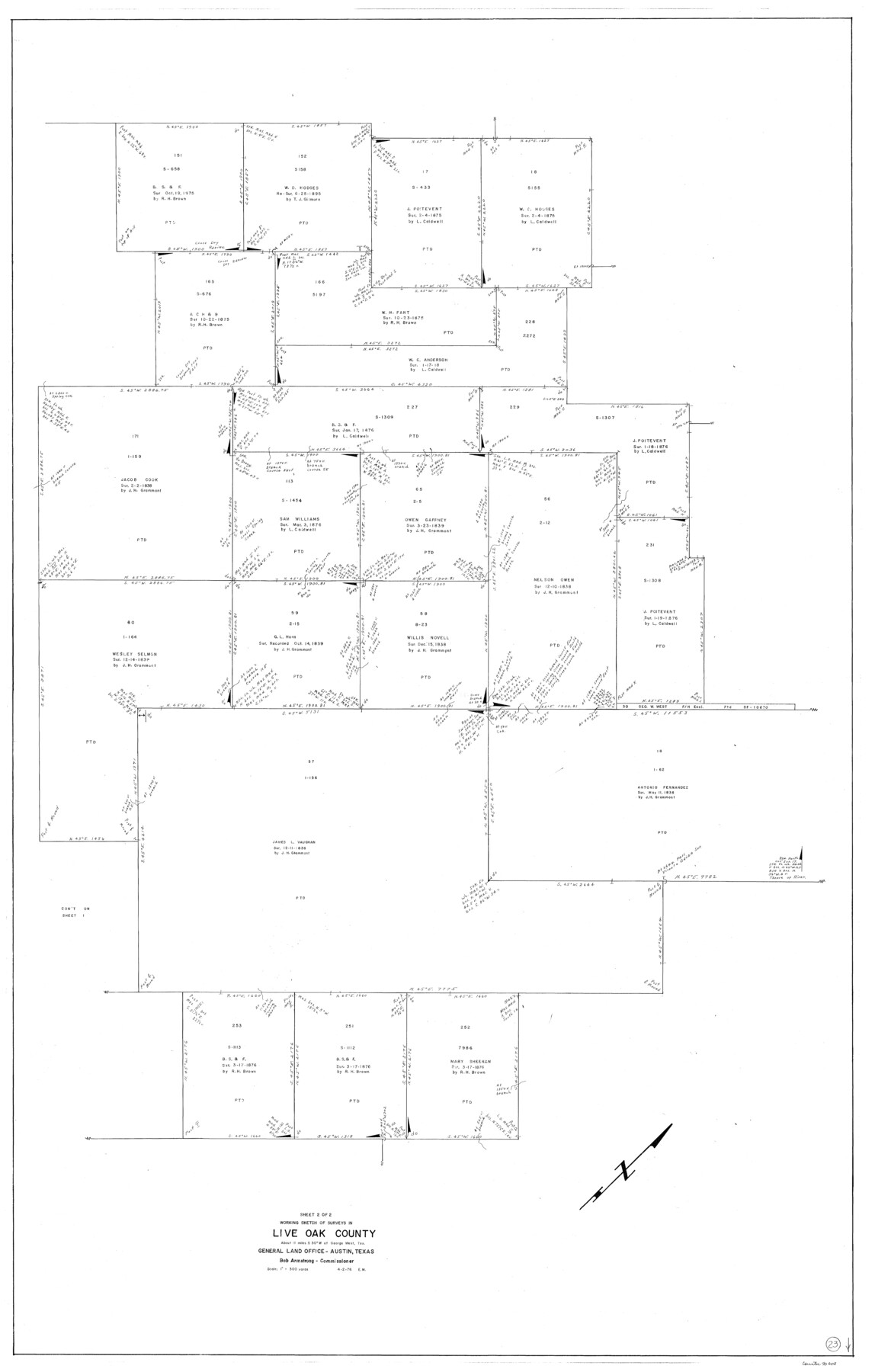
Live Oak County Working Sketch 23
-
Map/Doc
70608
-
Collection
General Map Collection
-
Object Dates
4/2/1976 (Creation Date)
-
People and Organizations
Elbert Menzel (Draftsman)
-
Counties
Live Oak
-
Subjects
Surveying Working Sketch
-
Height x Width
68.2 x 43.5 inches
173.2 x 110.5 cm
-
Scale
1" = 300 varas
Part of: General Map Collection
Flight Mission No. DCL-7C, Frame 143, Kenedy County

Print $20.00
- Digital $50.00
Flight Mission No. DCL-7C, Frame 143, Kenedy County
1943
Size 18.6 x 22.3 inches
Map/Doc 86100
Wilson County Sketch File A

Print $4.00
- Digital $50.00
Wilson County Sketch File A
1898
Size 8.3 x 7.4 inches
Map/Doc 40423
Scurry County Working Sketch 3

Print $20.00
- Digital $50.00
Scurry County Working Sketch 3
1941
Size 20.7 x 12.4 inches
Map/Doc 63832
Right of Way and Track Map Texas & New Orleans R.R. Co. operated by the T. & N. O. R.R. Co. Dallas-Sabine Branch

Print $40.00
- Digital $50.00
Right of Way and Track Map Texas & New Orleans R.R. Co. operated by the T. & N. O. R.R. Co. Dallas-Sabine Branch
1918
Size 26.4 x 56.6 inches
Map/Doc 64152
Harris County Working Sketch 8

Print $20.00
- Digital $50.00
Harris County Working Sketch 8
1904
Size 26.8 x 23.3 inches
Map/Doc 65900
Flight Mission No. CGI-3N, Frame 126, Cameron County

Print $20.00
- Digital $50.00
Flight Mission No. CGI-3N, Frame 126, Cameron County
1954
Size 18.5 x 22.1 inches
Map/Doc 84599
Dallas County Sketch File 15

Print $10.00
- Digital $50.00
Dallas County Sketch File 15
1863
Size 11.5 x 8.5 inches
Map/Doc 20430
Dickens County Working Sketch 3

Print $20.00
- Digital $50.00
Dickens County Working Sketch 3
Size 17.5 x 15.3 inches
Map/Doc 68650
Victoria County Sketch File 1

Print $20.00
- Digital $50.00
Victoria County Sketch File 1
1853
Size 12.9 x 17.3 inches
Map/Doc 12595
Colorado River, Wharton Sheet

Print $6.00
- Digital $50.00
Colorado River, Wharton Sheet
1941
Size 27.3 x 35.7 inches
Map/Doc 65314
Flight Mission No. BRA-16M, Frame 69, Jefferson County

Print $20.00
- Digital $50.00
Flight Mission No. BRA-16M, Frame 69, Jefferson County
1953
Size 18.6 x 22.2 inches
Map/Doc 85686
You may also like
Map showing the environs of Brazos Island, Texas

Print $20.00
- Digital $50.00
Map showing the environs of Brazos Island, Texas
Size 18.2 x 25.0 inches
Map/Doc 72925
Reeves County Sketch File 14

Print $4.00
- Digital $50.00
Reeves County Sketch File 14
1872
Size 8.0 x 12.7 inches
Map/Doc 35192
Dimmit County Working Sketch 22

Print $20.00
- Digital $50.00
Dimmit County Working Sketch 22
1951
Size 37.3 x 38.7 inches
Map/Doc 68683
General Highway Map. Detail of Cities and Towns in Tarrant County, Texas [Fort Worth and vicinity]
![79252, General Highway Map. Detail of Cities and Towns in Tarrant County, Texas [Fort Worth and vicinity], Texas State Library and Archives](https://historictexasmaps.com/wmedia_w700/maps/79252-GC.tif.jpg)
Print $20.00
General Highway Map. Detail of Cities and Towns in Tarrant County, Texas [Fort Worth and vicinity]
1940
Size 24.9 x 18.2 inches
Map/Doc 79252
Map of Cass County

Print $20.00
- Digital $50.00
Map of Cass County
1847
Size 21.3 x 18.4 inches
Map/Doc 3368
Diefert Situs Orbis Hydrographorum ab eo quem Ptolomeus Posuit

Print $20.00
- Digital $50.00
Diefert Situs Orbis Hydrographorum ab eo quem Ptolomeus Posuit
1522
Size 13.9 x 19.1 inches
Map/Doc 96578
Pecos County Working Sketch 101

Print $20.00
- Digital $50.00
Pecos County Working Sketch 101
1970
Size 43.3 x 31.1 inches
Map/Doc 71574
Flight Mission No. BRA-8M, Frame 77, Jefferson County

Print $20.00
- Digital $50.00
Flight Mission No. BRA-8M, Frame 77, Jefferson County
1953
Size 15.9 x 15.7 inches
Map/Doc 85597
Schleicher County Rolled Sketch 25

Print $20.00
- Digital $50.00
Schleicher County Rolled Sketch 25
1969
Size 32.3 x 37.9 inches
Map/Doc 9908

Howard County Working Sketch 13

Print $20.00
- Digital $50.00
Howard County Working Sketch 13
1983
Size 33.3 x 37.3 inches
Map/Doc 66281
Map of Eastern Portion G.C. & S.F.R.R.Co., Block 194

Print $20.00
- Digital $50.00
Map of Eastern Portion G.C. & S.F.R.R.Co., Block 194
Size 35.6 x 26.8 inches
Map/Doc 92421