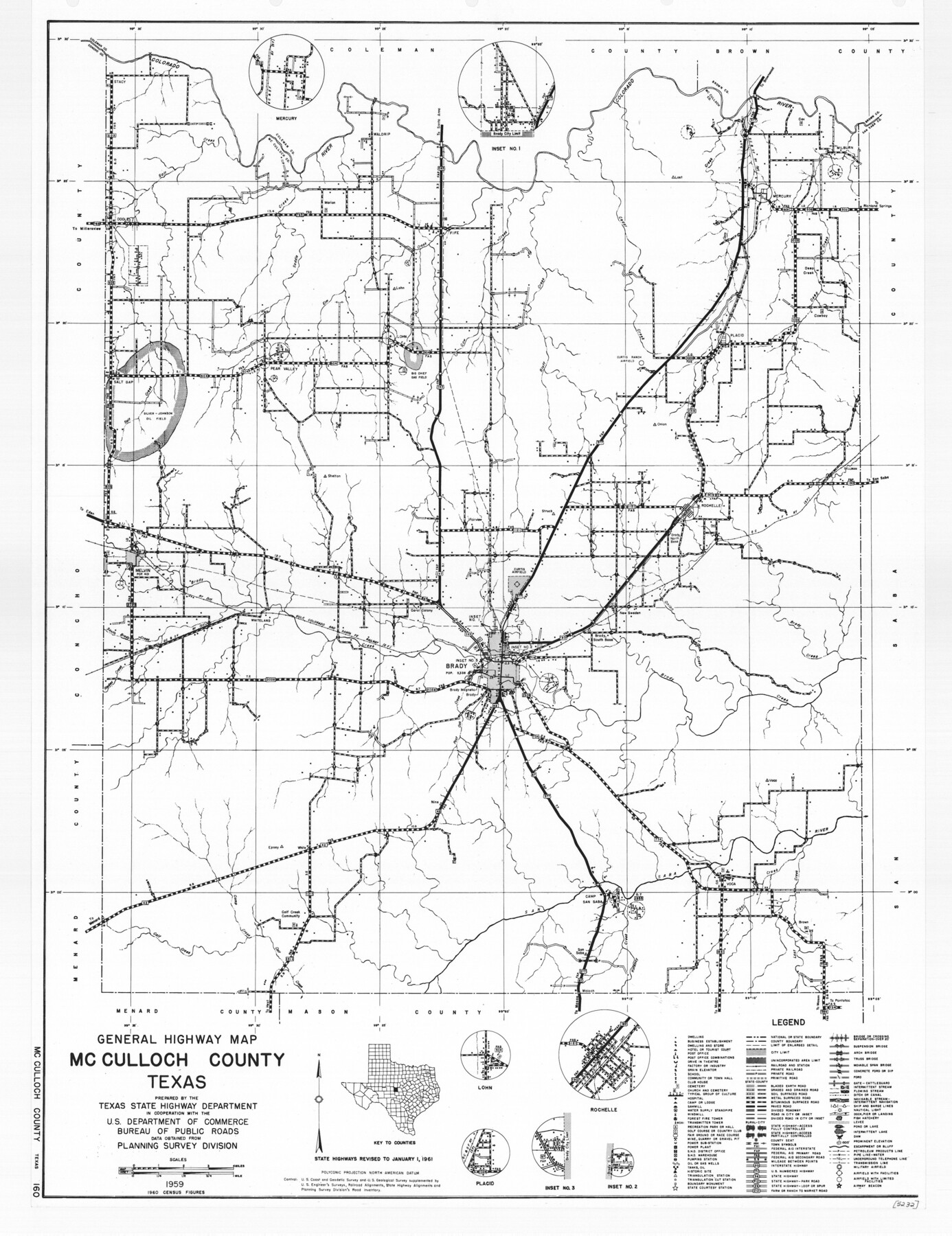
General Highway Map, McCulloch County, Texas
-
Map/Doc
79588
-
Collection
Texas State Library and Archives
-
Object Dates
1961 (Creation Date)
-
People and Organizations
Texas State Highway Department (Publisher)
-
Counties
McCulloch
-
Subjects
County
-
Height x Width
25.0 x 19.3 inches
63.5 x 49.0 cm
-
Comments
Prints available courtesy of the Texas State Library and Archives.
More info can be found here: TSLAC Map 05232
Part of: Texas State Library and Archives
General Highway Map, Wheeler County, Texas

Print $20.00
General Highway Map, Wheeler County, Texas
1961
Size 18.1 x 24.9 inches
Map/Doc 79708
General Highway Map, McLennan County, Texas

Print $20.00
General Highway Map, McLennan County, Texas
1961
Size 18.2 x 24.6 inches
Map/Doc 79589
General Highway Map, Walker County, Texas

Print $20.00
General Highway Map, Walker County, Texas
1940
Size 24.9 x 18.4 inches
Map/Doc 79269
General Highway Map, Yoakum County, Texas

Print $20.00
General Highway Map, Yoakum County, Texas
1940
Size 18.3 x 24.9 inches
Map/Doc 79285
General Highway Map, Jefferson County, Texas

Print $20.00
General Highway Map, Jefferson County, Texas
1961
Size 24.6 x 18.3 inches
Map/Doc 79537
Mapa de los Estados Unidos de Méjico, Segun lo organizado y definido por las varias actas del Congreso de dicha Republica: y construido por las mejores autoridades

Print $20.00
Mapa de los Estados Unidos de Méjico, Segun lo organizado y definido por las varias actas del Congreso de dicha Republica: y construido por las mejores autoridades
1846
Size 30.8 x 42.4 inches
Map/Doc 79727
General Highway Map, Kimble County, Texas

Print $20.00
General Highway Map, Kimble County, Texas
1940
Size 24.8 x 18.3 inches
Map/Doc 79160
General Highway Map, Wilbarger County, Texas

Print $20.00
General Highway Map, Wilbarger County, Texas
1940
Size 24.7 x 18.1 inches
Map/Doc 79278
Jules A. Appler's Map of San Antonio, Texas and Suburbs

Print $20.00
Jules A. Appler's Map of San Antonio, Texas and Suburbs
1900
Size 43.0 x 29.7 inches
Map/Doc 79303
Map Showing Colonel A.W. Doniphan's Route through the States of New Mexico, Chihuahua and Coahuila

Print $20.00
Map Showing Colonel A.W. Doniphan's Route through the States of New Mexico, Chihuahua and Coahuila
1847
Size 16.9 x 14.0 inches
Map/Doc 79729
County Map of the Pan-Handle of Texas, and the line of the Denver, Texas and Ft. Worth R'y

Print $20.00
County Map of the Pan-Handle of Texas, and the line of the Denver, Texas and Ft. Worth R'y
1888
Size 7.5 x 10.9 inches
Map/Doc 76296
General Highway Map, Reeves County, Texas

Print $20.00
General Highway Map, Reeves County, Texas
1940
Size 24.8 x 18.2 inches
Map/Doc 79227
You may also like
Fractional Township No. 9 South Range No. 2 East of the Indian Meridian, Indian Territory

Print $20.00
- Digital $50.00
Fractional Township No. 9 South Range No. 2 East of the Indian Meridian, Indian Territory
1898
Size 19.1 x 24.2 inches
Map/Doc 75203
[Sections 58-63, I. & G. N. Block 1 and area adjacent to the west]
![91637, [Sections 58-63, I. & G. N. Block 1 and area adjacent to the west], Twichell Survey Records](https://historictexasmaps.com/wmedia_w700/maps/91637-1.tif.jpg)
Print $20.00
- Digital $50.00
[Sections 58-63, I. & G. N. Block 1 and area adjacent to the west]
Size 23.0 x 15.3 inches
Map/Doc 91637
San Patricio County Working Sketch 2

Print $20.00
- Digital $50.00
San Patricio County Working Sketch 2
1911
Size 18.6 x 15.1 inches
Map/Doc 63764

Harris County Working Sketch 23

Print $20.00
- Digital $50.00
Harris County Working Sketch 23
1926
Size 14.0 x 20.0 inches
Map/Doc 65915
Karnes County Sketch File 14

Print $6.00
- Digital $50.00
Karnes County Sketch File 14
1897
Size 9.7 x 6.2 inches
Map/Doc 28615
Flight Mission No. DQN-1K, Frame 104, Calhoun County

Print $20.00
- Digital $50.00
Flight Mission No. DQN-1K, Frame 104, Calhoun County
1953
Size 18.4 x 22.1 inches
Map/Doc 84171
Leon County Sketch File 34

Print $10.00
- Digital $50.00
Leon County Sketch File 34
1962
Size 11.1 x 8.7 inches
Map/Doc 94787
Railroad Track Map, H&TCRRCo., Falls County, Texas

Print $4.00
- Digital $50.00
Railroad Track Map, H&TCRRCo., Falls County, Texas
1918
Size 11.8 x 18.6 inches
Map/Doc 62836
Menard County Working Sketch 2

Print $20.00
- Digital $50.00
Menard County Working Sketch 2
1906
Size 17.8 x 12.5 inches
Map/Doc 70949
Jasper County Working Sketch 30

Print $20.00
- Digital $50.00
Jasper County Working Sketch 30
1956
Size 33.5 x 38.6 inches
Map/Doc 66492
Childress County

Print $20.00
- Digital $50.00
Childress County
1921
Size 44.1 x 32.2 inches
Map/Doc 4746