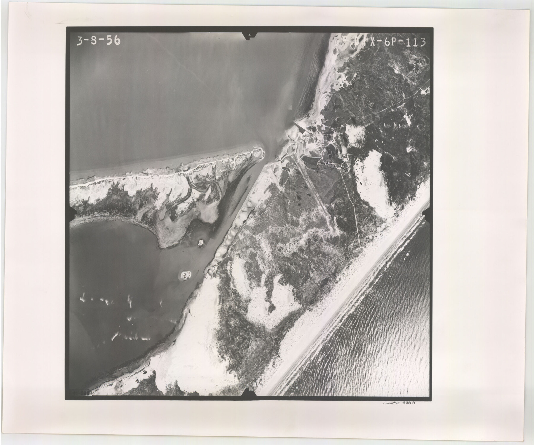
Flight Mission No. DIX-6P, Frame 113, Aransas County
DIX-6P-113
-
Map/Doc
83819
-
Collection
General Map Collection
-
Object Dates
1956/3/8 (Creation Date)
-
People and Organizations
U. S. Department of Agriculture (Publisher)
-
Counties
Aransas
-
Subjects
Aerial Photograph
-
Height x Width
18.8 x 22.4 inches
47.8 x 56.9 cm
-
Comments
Flown by V. L. Beavers and Associates of San Antonio, Texas.
Part of: General Map Collection
Comanche County Working Sketch 16

Print $20.00
- Digital $50.00
Comanche County Working Sketch 16
1969
Size 16.5 x 23.8 inches
Map/Doc 68150
Young County Sketch File 6

Print $14.00
- Digital $50.00
Young County Sketch File 6
Size 13.0 x 8.2 inches
Map/Doc 40852
Motley County Sketch File 37 (S)

Print $22.00
- Digital $50.00
Motley County Sketch File 37 (S)
Size 11.3 x 8.7 inches
Map/Doc 32222
San Jacinto County Sketch File 7

Print $10.00
- Digital $50.00
San Jacinto County Sketch File 7
1848
Size 8.1 x 10.0 inches
Map/Doc 35705
Aransas County Sketch File 14a

Print $40.00
- Digital $50.00
Aransas County Sketch File 14a
1891
Size 16.7 x 15.8 inches
Map/Doc 10821
Freestone County Working Sketch 29

Print $20.00
- Digital $50.00
Freestone County Working Sketch 29
1994
Size 36.0 x 45.5 inches
Map/Doc 69271
Flight Mission No. DQN-1K, Frame 122, Calhoun County

Print $20.00
- Digital $50.00
Flight Mission No. DQN-1K, Frame 122, Calhoun County
1953
Size 18.5 x 22.2 inches
Map/Doc 84188
Houston County Working Sketch 24

Print $40.00
- Digital $50.00
Houston County Working Sketch 24
1983
Size 43.9 x 77.2 inches
Map/Doc 66254
Map of Rains County

Print $20.00
- Digital $50.00
Map of Rains County
1873
Size 11.9 x 11.2 inches
Map/Doc 3973
Castro County Sketch File 15

Print $4.00
- Digital $50.00
Castro County Sketch File 15
1978
Size 11.2 x 8.7 inches
Map/Doc 17511
Kenedy County Rolled Sketch 3

Print $40.00
- Digital $50.00
Kenedy County Rolled Sketch 3
1904
Size 40.1 x 57.4 inches
Map/Doc 9329
Medina County Rolled Sketch 17

Print $20.00
- Digital $50.00
Medina County Rolled Sketch 17
1979
Size 32.3 x 18.9 inches
Map/Doc 6750
You may also like
Hidalgo County Working Sketch 9

Print $20.00
- Digital $50.00
Hidalgo County Working Sketch 9
1984
Size 27.2 x 15.0 inches
Map/Doc 66186
Travis County Working Sketch 20

Print $20.00
- Digital $50.00
Travis County Working Sketch 20
1945
Size 28.5 x 31.9 inches
Map/Doc 69404
Montague County Working Sketch 23

Print $20.00
- Digital $50.00
Montague County Working Sketch 23
1953
Size 31.2 x 27.5 inches
Map/Doc 71089
Andrews County Sketch File 1

Print $6.00
- Digital $50.00
Andrews County Sketch File 1
Size 9.0 x 13.6 inches
Map/Doc 12818
Flight Mission No. BRE-1P, Frame 129, Nueces County

Print $20.00
- Digital $50.00
Flight Mission No. BRE-1P, Frame 129, Nueces County
1956
Size 18.5 x 22.6 inches
Map/Doc 86695
Flight Mission No. CGI-3N, Frame 125, Cameron County

Print $20.00
- Digital $50.00
Flight Mission No. CGI-3N, Frame 125, Cameron County
1954
Size 18.6 x 22.2 inches
Map/Doc 84598

Rio Grande Rectification Project, El Paso and Juarez Valley

Print $20.00
- Digital $50.00
Rio Grande Rectification Project, El Paso and Juarez Valley
1935
Size 10.7 x 29.6 inches
Map/Doc 60862
Andrews County Working Sketch 24

Print $40.00
- Digital $50.00
Andrews County Working Sketch 24
1980
Size 55.5 x 37.4 inches
Map/Doc 67070
Reagan County Rolled Sketch 38

Print $20.00
- Digital $50.00
Reagan County Rolled Sketch 38
1964
Size 39.2 x 40.5 inches
Map/Doc 9830
Chambers County Rolled Sketch 30

Print $20.00
- Digital $50.00
Chambers County Rolled Sketch 30
1952
Size 26.7 x 37.9 inches
Map/Doc 5430
Block 2 T. & N. Ry. Co., Block 97 H. T. C. Ry. Co.

Print $40.00
- Digital $50.00
Block 2 T. & N. Ry. Co., Block 97 H. T. C. Ry. Co.
1888
Size 41.5 x 48.1 inches
Map/Doc 89874