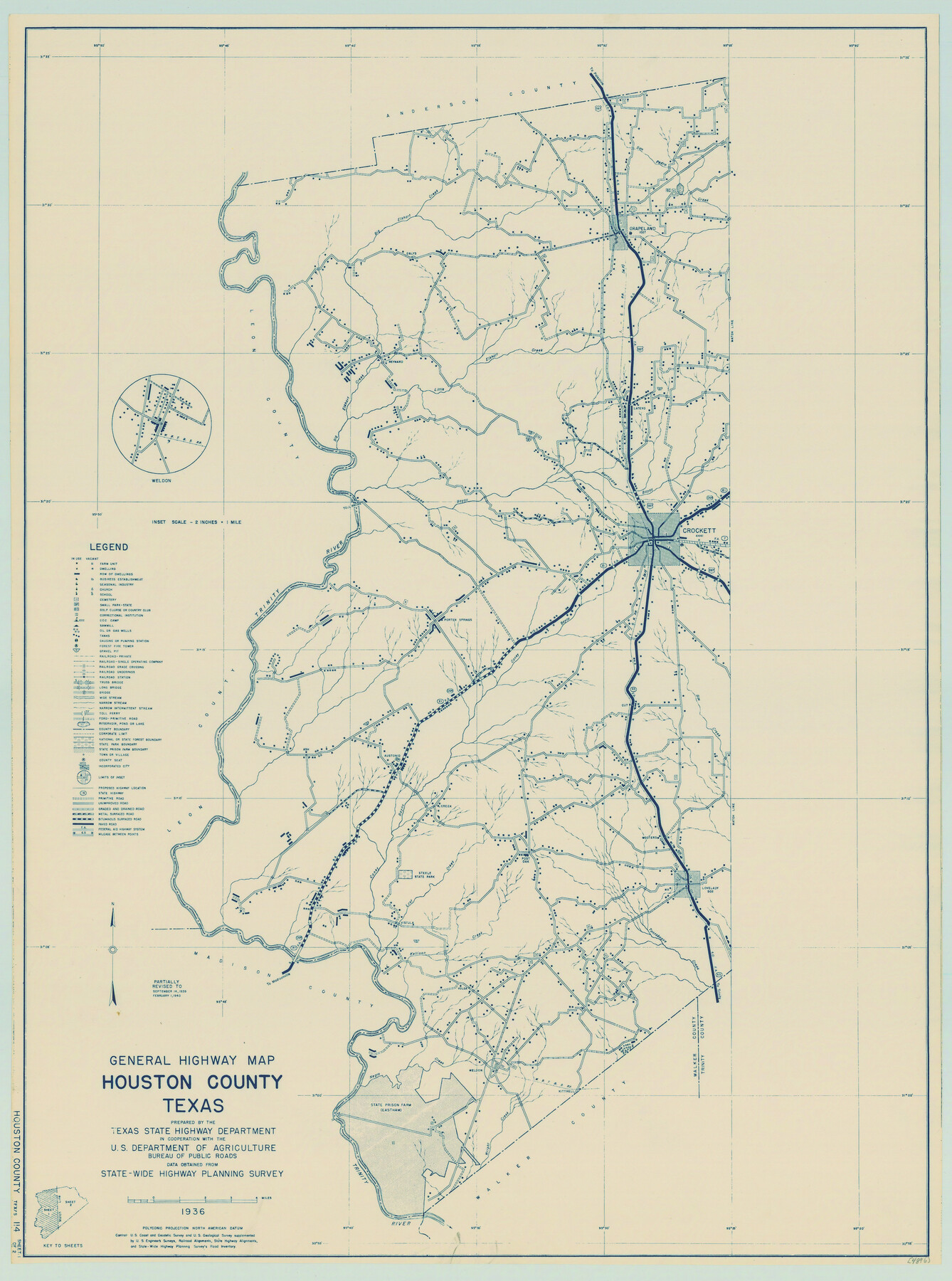
General Highway Map, Houston County, Texas
-
Map/Doc
79132
-
Collection
Texas State Library and Archives
-
Object Dates
1940 (Creation Date)
-
People and Organizations
Texas State Highway Department (Publisher)
-
Counties
Houston
-
Subjects
County
-
Height x Width
25.0 x 18.6 inches
63.5 x 47.2 cm
-
Comments
Prints available courtesy of the Texas State Library and Archives.
More info can be found here: TSLAC Map 04896
Part of: Texas State Library and Archives
General Highway Map. Detail of Cities and Towns in Erath County, Texas

Print $20.00
General Highway Map. Detail of Cities and Towns in Erath County, Texas
1961
Size 18.2 x 24.7 inches
Map/Doc 79461
General Highway Map, Kimble County, Texas

Print $20.00
General Highway Map, Kimble County, Texas
1961
Size 24.6 x 18.2 inches
Map/Doc 79554
General Highway Map, Castro County, Texas

Print $20.00
General Highway Map, Castro County, Texas
1940
Size 18.5 x 25.1 inches
Map/Doc 79043
Revised Map of Austin, Texas

Print $20.00
Revised Map of Austin, Texas
1885
Size 16.5 x 14.0 inches
Map/Doc 76272
General Highway Map, Collingsworth County, Texas

Print $20.00
General Highway Map, Collingsworth County, Texas
1940
Size 18.3 x 25.2 inches
Map/Doc 79053
General Highway Map. Detail of Cities and Towns in Travis County, Texas

Print $20.00
General Highway Map. Detail of Cities and Towns in Travis County, Texas
1961
Size 18.1 x 24.7 inches
Map/Doc 79683
General Highway Map, Henderson County, Texas

Print $20.00
General Highway Map, Henderson County, Texas
1961
Size 24.8 x 18.2 inches
Map/Doc 79516
Map of the Country Between the Frontiers of Arkansas and New Mexico embracing the section explored in 1849, 51, and 52

Print $40.00
Map of the Country Between the Frontiers of Arkansas and New Mexico embracing the section explored in 1849, 51, and 52
1852
Size 29.6 x 62.1 inches
Map/Doc 76219
General Highway Map, Randall County, Texas

Print $20.00
General Highway Map, Randall County, Texas
1940
Size 18.3 x 25.0 inches
Map/Doc 79224
Military Map of Western Texas

Print $20.00
Military Map of Western Texas
1884
Size 24.1 x 38.2 inches
Map/Doc 76315
General Highway Map, Starr County, Texas

Print $20.00
General Highway Map, Starr County, Texas
1940
Size 24.7 x 18.5 inches
Map/Doc 79245
General Highway Map. Detail of Cities and Towns in Lubbock County, Texas [Lubbock and vicinity]
![79579, General Highway Map. Detail of Cities and Towns in Lubbock County, Texas [Lubbock and vicinity], Texas State Library and Archives](https://historictexasmaps.com/wmedia_w700/maps/79579.tif.jpg)
Print $20.00
General Highway Map. Detail of Cities and Towns in Lubbock County, Texas [Lubbock and vicinity]
1961
Size 18.2 x 24.7 inches
Map/Doc 79579
You may also like
Tom Green County Sketch File 51

Print $20.00
- Digital $50.00
Tom Green County Sketch File 51
1884
Size 44.0 x 27.5 inches
Map/Doc 10403
Kimble County Working Sketch 83

Print $20.00
- Digital $50.00
Kimble County Working Sketch 83
1971
Size 31.3 x 31.1 inches
Map/Doc 70151
Parker County Boundary File 2

Print $8.00
- Digital $50.00
Parker County Boundary File 2
Size 11.2 x 8.8 inches
Map/Doc 57835
Aransas County Sketch File 28

Print $16.00
- Digital $50.00
Aransas County Sketch File 28
1973
Size 11.3 x 8.8 inches
Map/Doc 13226
Brewster County Rolled Sketch 19B

Print $40.00
- Digital $50.00
Brewster County Rolled Sketch 19B
1881
Size 48.5 x 39.4 inches
Map/Doc 8472
San Patricio County Rolled Sketch 53D

Print $20.00
- Digital $50.00
San Patricio County Rolled Sketch 53D
Size 20.1 x 22.1 inches
Map/Doc 7739
Presidio County Rolled Sketch 71

Print $20.00
- Digital $50.00
Presidio County Rolled Sketch 71
1941
Size 31.7 x 42.9 inches
Map/Doc 7361
Coke County Sketch File 24

Print $6.00
- Digital $50.00
Coke County Sketch File 24
1927
Size 11.1 x 8.8 inches
Map/Doc 18615
Zapata County Working Sketch 24

Print $20.00
- Digital $50.00
Zapata County Working Sketch 24
1992
Size 28.2 x 23.9 inches
Map/Doc 62075
Flight Mission No. DQN-5K, Frame 80, Calhoun County

Print $20.00
- Digital $50.00
Flight Mission No. DQN-5K, Frame 80, Calhoun County
1953
Size 18.5 x 22.1 inches
Map/Doc 84413
General Highway Map, Hays County, Texas

Print $20.00
General Highway Map, Hays County, Texas
1961
Size 18.1 x 24.7 inches
Map/Doc 79513
Williamson County Working Sketch 19

Print $20.00
- Digital $50.00
Williamson County Working Sketch 19
1991
Size 31.2 x 40.0 inches
Map/Doc 72579