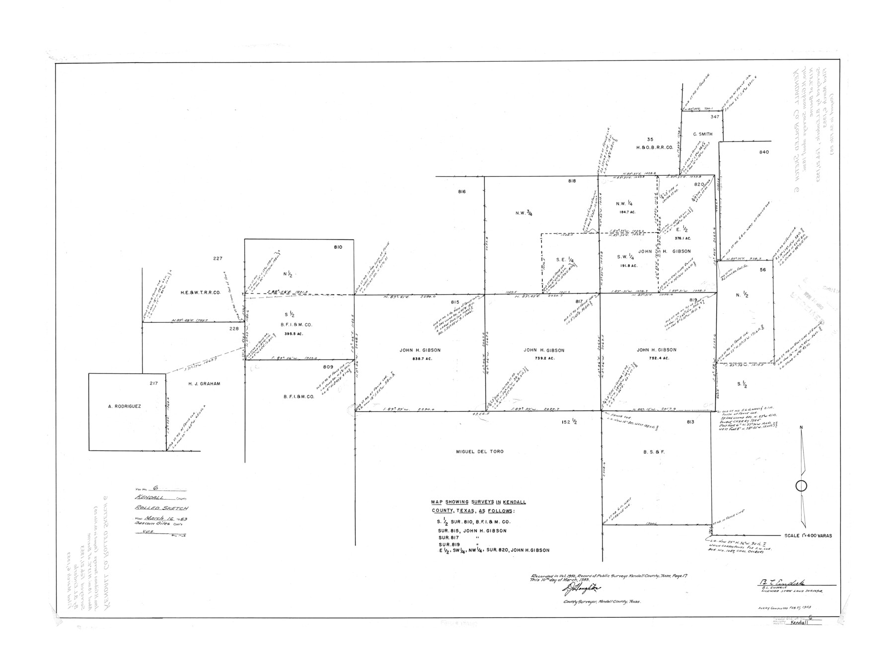
Kendall County Rolled Sketch 6
Map showing surveys in Kendall County, Texas as follows: S 1/2 sur. 810, B. F. I. & M. Co., sur. 815, John H. Gibson, sur. 817, John H. Gibson, sur. 819, John H. Gibson, E 1/2, SW 1/4, NW 1/4 sur. 820, John H. Gibson
-
Map/Doc
6459
-
Collection
General Map Collection
-
Object Dates
1953/2/21 (Survey Date)
1953/3/16 (File Date)
-
People and Organizations
B.L. Enderle (Surveyor/Engineer)
-
Counties
Kendall
-
Subjects
Surveying Rolled Sketch
-
Height x Width
29.6 x 39.4 inches
75.2 x 100.1 cm
-
Scale
1" = 400 varas
-
Comments
See Kendall County Sketch File 28 (28733) for report.
Related maps
Kendall County Sketch File 28

Print $12.00
- Digital $50.00
Kendall County Sketch File 28
1953
Size 14.3 x 8.9 inches
Map/Doc 28733
Part of: General Map Collection
Kerr County Working Sketch 15

Print $20.00
- Digital $50.00
Kerr County Working Sketch 15
1953
Size 36.2 x 38.6 inches
Map/Doc 70046
Treaty to Resolve Pending Boundary Differences and Maintain the Rio Grande and Colorado River as the International Boundary Between the United States of American and Mexico

Print $20.00
- Digital $50.00
Treaty to Resolve Pending Boundary Differences and Maintain the Rio Grande and Colorado River as the International Boundary Between the United States of American and Mexico
1970
Size 11.0 x 35.3 inches
Map/Doc 83103
Orange County Sketch File 32

Print $6.00
- Digital $50.00
Orange County Sketch File 32
1926
Size 14.3 x 8.7 inches
Map/Doc 33360
Cameron County Rolled Sketch 20D

Print $20.00
- Digital $50.00
Cameron County Rolled Sketch 20D
Size 13.7 x 12.1 inches
Map/Doc 5476
King County Boundary File 3

Print $54.00
- Digital $50.00
King County Boundary File 3
Size 14.1 x 8.5 inches
Map/Doc 64896
Wood County Working Sketch 7

Print $20.00
- Digital $50.00
Wood County Working Sketch 7
1942
Size 41.0 x 37.7 inches
Map/Doc 62007
Uvalde County Working Sketch 45

Print $20.00
- Digital $50.00
Uvalde County Working Sketch 45
1978
Size 18.5 x 28.2 inches
Map/Doc 72115
Oldham County Boundary File 3

Print $80.00
- Digital $50.00
Oldham County Boundary File 3
Size 20.0 x 58.0 inches
Map/Doc 57771
Flight Mission No. CGI-3N, Frame 120, Cameron County

Print $20.00
- Digital $50.00
Flight Mission No. CGI-3N, Frame 120, Cameron County
1954
Size 18.8 x 22.3 inches
Map/Doc 84593
Map of the Lower Rio Grande, accompanying report of the special committee on Texas frontier troubles, appointed by the House of Representatives, Jan. 6, 1876

Print $20.00
- Digital $50.00
Map of the Lower Rio Grande, accompanying report of the special committee on Texas frontier troubles, appointed by the House of Representatives, Jan. 6, 1876
1876
Size 12.1 x 17.6 inches
Map/Doc 95406
Parker County Sketch File 34

Print $20.00
- Digital $50.00
Parker County Sketch File 34
1878
Size 21.3 x 13.6 inches
Map/Doc 12148
Index to the following sixteen sheets, being a compleat chart of the West Indies with letters in the margin to direct the placing of the different sheets in their proper places

Print $20.00
- Digital $50.00
Index to the following sixteen sheets, being a compleat chart of the West Indies with letters in the margin to direct the placing of the different sheets in their proper places
1792
Size 21.5 x 28.6 inches
Map/Doc 96440
You may also like
Real County Working Sketch 21

Print $20.00
- Digital $50.00
Real County Working Sketch 21
1944
Size 24.8 x 35.7 inches
Map/Doc 71913
Nueces County Sketch File 69

Print $6.00
- Digital $50.00
Nueces County Sketch File 69
Size 11.1 x 8.7 inches
Map/Doc 33004
Outer Continental Shelf Leasing Maps (Texas Offshore Operations)

Print $20.00
- Digital $50.00
Outer Continental Shelf Leasing Maps (Texas Offshore Operations)
1954
Size 22.3 x 17.3 inches
Map/Doc 75833
Eastland County Sketch File 1

Print $8.00
- Digital $50.00
Eastland County Sketch File 1
Size 9.0 x 7.9 inches
Map/Doc 21555
Floyd County Working Sketch 6

Print $20.00
- Digital $50.00
Floyd County Working Sketch 6
1965
Size 22.9 x 31.3 inches
Map/Doc 69185
Boundary Line Between Texas and New Mexico, Supreme Court Decision - Oct. Term, 1930

Print $304.00
Boundary Line Between Texas and New Mexico, Supreme Court Decision - Oct. Term, 1930
1930
Map/Doc 81688
C. A. Pierce's Subdivision of Dick Slaughter Land

Print $20.00
- Digital $50.00
C. A. Pierce's Subdivision of Dick Slaughter Land
Size 37.7 x 17.1 inches
Map/Doc 90301
Lubbock County Lines

Print $20.00
- Digital $50.00
Lubbock County Lines
1892
Size 22.7 x 22.6 inches
Map/Doc 91308
Map of Located Land of Gulf, Colorado & Santa Fe Ry. Co. through Denton

Print $40.00
- Digital $50.00
Map of Located Land of Gulf, Colorado & Santa Fe Ry. Co. through Denton
Size 55.5 x 25.8 inches
Map/Doc 64341
The Republic County of Matagorda. Proposed, Late Fall 1837

Print $20.00
The Republic County of Matagorda. Proposed, Late Fall 1837
2020
Size 21.0 x 21.7 inches
Map/Doc 96214
Erath County Working Sketch 28

Print $20.00
- Digital $50.00
Erath County Working Sketch 28
1970
Size 31.8 x 31.6 inches
Map/Doc 69109
McMullen County Sketch File 29

Print $20.00
- Digital $50.00
McMullen County Sketch File 29
1883
Size 35.8 x 15.4 inches
Map/Doc 12062