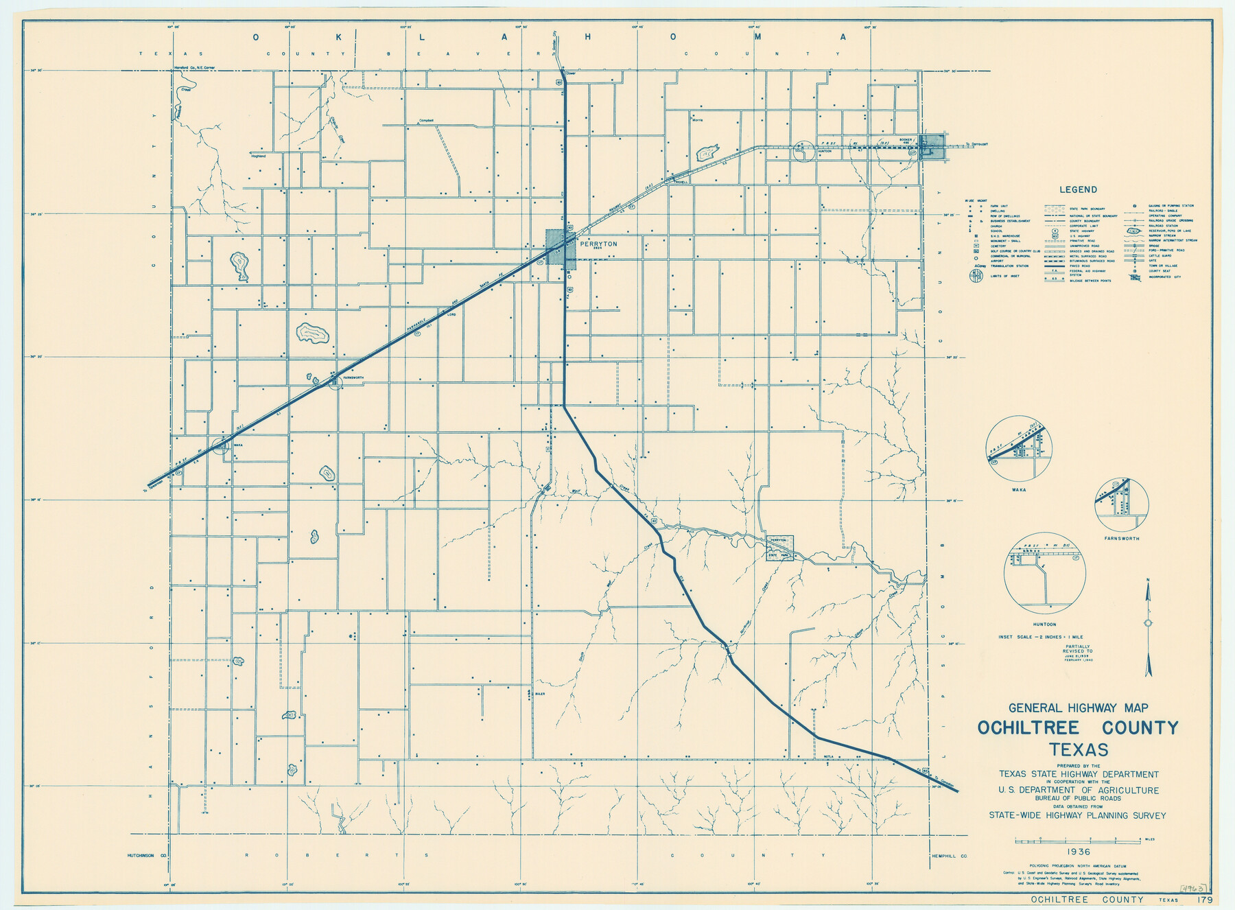
General Highway Map, Ochiltree County, Texas
-
Map/Doc
79211
-
Collection
Texas State Library and Archives
-
Object Dates
1940 (Creation Date)
-
People and Organizations
Texas State Highway Department (Publisher)
-
Counties
Ochiltree
-
Subjects
County
-
Height x Width
18.2 x 24.8 inches
46.2 x 63.0 cm
-
Comments
Prints available courtesy of the Texas State Library and Archives.
More info can be found here: TSLAC Map 04963
Part of: Texas State Library and Archives
General Highway Map, Lamar County, Texas

Print $20.00
General Highway Map, Lamar County, Texas
1940
Size 24.8 x 18.5 inches
Map/Doc 79167
General Highway Map, Van Zandt County, Texas

Print $20.00
General Highway Map, Van Zandt County, Texas
1961
Size 18.2 x 24.8 inches
Map/Doc 79696
General Highway Map, Smith County, Texas

Print $20.00
General Highway Map, Smith County, Texas
1961
Size 25.1 x 18.3 inches
Map/Doc 79654
General Highway Map, McMullen County, Texas

Print $20.00
General Highway Map, McMullen County, Texas
1961
Size 24.7 x 18.3 inches
Map/Doc 79592
Topographic Map of Texas and Oklahoma Boundary, Fort Augur Area

Print $20.00
Topographic Map of Texas and Oklahoma Boundary, Fort Augur Area
1924
Size 17.2 x 33.7 inches
Map/Doc 79754
General Highway Map, Lavaca County, Texas

Print $20.00
General Highway Map, Lavaca County, Texas
1961
Size 24.6 x 18.1 inches
Map/Doc 79566
General Highway Map, Angelina County, Texas

Print $20.00
General Highway Map, Angelina County, Texas
1940
Size 18.5 x 24.9 inches
Map/Doc 79003
General Highway Map, Dawson County, Texas

Print $20.00
General Highway Map, Dawson County, Texas
1940
Size 18.5 x 25.2 inches
Map/Doc 79071
General Highway Map. Detail of Cities and Towns in Travis County, Texas. City Map, Austin and vicinity, Travis County, Texas

Print $20.00
General Highway Map. Detail of Cities and Towns in Travis County, Texas. City Map, Austin and vicinity, Travis County, Texas
1961
Size 18.1 x 24.7 inches
Map/Doc 79687
General Highway Map, Fayette County, Texas

Print $20.00
General Highway Map, Fayette County, Texas
1961
Size 18.2 x 24.5 inches
Map/Doc 79465
General Highway Map, Dallas County, Rockwall County, Texas

Print $20.00
General Highway Map, Dallas County, Rockwall County, Texas
1961
Size 18.4 x 24.5 inches
Map/Doc 79430
General Highway Map, Kaufman County, Texas

Print $20.00
General Highway Map, Kaufman County, Texas
1939
Size 24.8 x 18.3 inches
Map/Doc 79152
You may also like
Travis County Rolled Sketch 61

Print $20.00
- Digital $50.00
Travis County Rolled Sketch 61
2023
Size 36.0 x 24.0 inches
Map/Doc 97184
Haskell County Boundary File 3

Print $6.00
- Digital $50.00
Haskell County Boundary File 3
Size 11.0 x 8.6 inches
Map/Doc 54539
[Lgs. 192-195, 176-179]
![90254, [Lgs. 192-195, 176-179], Twichell Survey Records](https://historictexasmaps.com/wmedia_w700/maps/90254-1.tif.jpg)
Print $20.00
- Digital $50.00
[Lgs. 192-195, 176-179]
Size 18.2 x 25.2 inches
Map/Doc 90254
[Block V and surrounding surveys]
![90293, [Block V and surrounding surveys], Twichell Survey Records](https://historictexasmaps.com/wmedia_w700/maps/90293-1.tif.jpg)
Print $20.00
- Digital $50.00
[Block V and surrounding surveys]
Size 12.0 x 12.6 inches
Map/Doc 90293
Brewster County Sketch File 24

Print $40.00
- Digital $50.00
Brewster County Sketch File 24
1957
Size 14.3 x 15.5 inches
Map/Doc 15831
Brazoria County Sketch File 40

Print $8.00
- Digital $50.00
Brazoria County Sketch File 40
1935
Size 14.3 x 8.9 inches
Map/Doc 15049
Panola County Sketch File 24

Print $8.00
- Digital $50.00
Panola County Sketch File 24
1939
Size 11.1 x 8.7 inches
Map/Doc 33494
San Augustine County Working Sketch 18

Print $20.00
- Digital $50.00
San Augustine County Working Sketch 18
1964
Size 22.7 x 23.1 inches
Map/Doc 63706
Presidio County Working Sketch 51

Print $20.00
- Digital $50.00
Presidio County Working Sketch 51
1953
Size 33.4 x 43.1 inches
Map/Doc 71728
Map of the Southern part of Texas

Print $20.00
- Digital $50.00
Map of the Southern part of Texas
1831
Size 17.5 x 21.3 inches
Map/Doc 94442
Texas and the Great War

Print $20.00
- Digital $50.00
Texas and the Great War
2017
Size 24.3 x 18.3 inches
Map/Doc 94412
