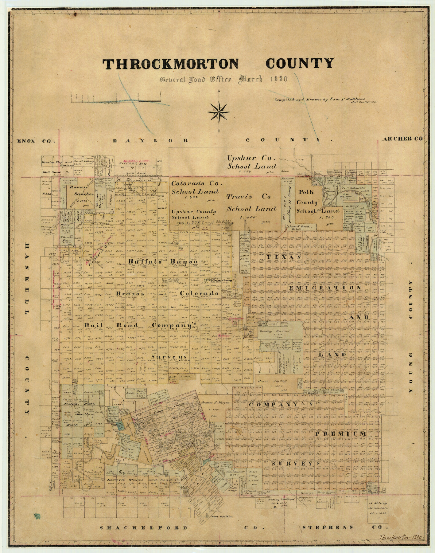
Throckmorton County
-
Map/Doc
4079
-
Collection
General Map Collection
-
Object Dates
3/1880 (Creation Date)
-
People and Organizations
Texas General Land Office (Publisher)
Sam. P. Matthews (Draftsman)
Sam. P. Matthews (Compiler)
-
Counties
Throckmorton
-
Subjects
County
-
Height x Width
24.5 x 19.3 inches
62.2 x 49.0 cm
-
Features
Old California Road
Phantom Hill and Fort Belknap Road
Old Camp Cooper
Fort Griffin
Fort Belknap Road
Phantom Hill Road
Clear Fork of the Brazos River
Hagood Creek
Throckmorton
Salt Fork of the Brazos River
Elm Creek
Williamsburg
Boggy Creek
Leopard Creek
Miller's Creek
Antelope Creek
Muggins Creek
Part of: General Map Collection
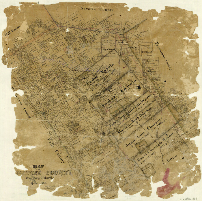
Map of Limestone County
Print $20.00
- Digital $50.00
Map of Limestone County
1869
Size 22.1 x 22.4 inches
Map/Doc 3818
McMullen County Sketch File 38

Print $20.00
- Digital $50.00
McMullen County Sketch File 38
1938
Size 31.3 x 17.5 inches
Map/Doc 12064
Right of Way & Track Map, St. Louis, Brownsville & Mexico Ry. operated by St. Louis, Brownsville & Mexico Ry. Co.

Print $40.00
- Digital $50.00
Right of Way & Track Map, St. Louis, Brownsville & Mexico Ry. operated by St. Louis, Brownsville & Mexico Ry. Co.
1919
Size 25.4 x 57.2 inches
Map/Doc 64621
Aransas County Rolled Sketch 16

Digital $50.00
Aransas County Rolled Sketch 16
Size 45.9 x 92.9 inches
Map/Doc 9005
Duval County Sketch File 4c1

Print $4.00
- Digital $50.00
Duval County Sketch File 4c1
1874
Size 10.4 x 7.9 inches
Map/Doc 21286

Delta County Sketch File 5

Print $2.00
- Digital $50.00
Delta County Sketch File 5
1886
Size 14.6 x 8.6 inches
Map/Doc 20676
Coke County Rolled Sketch 15A

Print $20.00
- Digital $50.00
Coke County Rolled Sketch 15A
1949
Size 43.8 x 44.3 inches
Map/Doc 8629
Edwards County Working Sketch 77

Print $20.00
- Digital $50.00
Edwards County Working Sketch 77
1960
Size 32.8 x 39.9 inches
Map/Doc 68953
Cass County Rolled Sketch 7

Print $20.00
- Digital $50.00
Cass County Rolled Sketch 7
1957
Size 28.3 x 33.5 inches
Map/Doc 5413
Flight Mission No. DQO-1K, Frame 116, Galveston County

Print $20.00
- Digital $50.00
Flight Mission No. DQO-1K, Frame 116, Galveston County
1952
Size 18.8 x 22.6 inches
Map/Doc 84994
Cameron County Rolled Sketch 10A

Print $71.00
- Digital $50.00
Cameron County Rolled Sketch 10A
Size 11.1 x 8.7 inches
Map/Doc 41749
You may also like
Johnson County Working Sketch 25

Print $20.00
- Digital $50.00
Johnson County Working Sketch 25
1998
Size 13.3 x 25.4 inches
Map/Doc 66638
Flight Mission No. CGI-3N, Frame 99, Cameron County

Print $20.00
- Digital $50.00
Flight Mission No. CGI-3N, Frame 99, Cameron County
1954
Size 18.5 x 22.1 inches
Map/Doc 84579
The Mexican Department of Brazos. Created, March 18, 1834

Print $20.00
The Mexican Department of Brazos. Created, March 18, 1834
2020
Size 19.7 x 21.7 inches
Map/Doc 95975
Flight Mission No. CUG-2P, Frame 25, Kleberg County

Print $20.00
- Digital $50.00
Flight Mission No. CUG-2P, Frame 25, Kleberg County
1956
Size 18.5 x 22.2 inches
Map/Doc 86189
Hood County Sketch File 22a

Print $5.00
- Digital $50.00
Hood County Sketch File 22a
Size 13.7 x 9.3 inches
Map/Doc 26617
Bailey County Sketch File 7

Print $8.00
- Digital $50.00
Bailey County Sketch File 7
1913
Size 14.0 x 8.7 inches
Map/Doc 13958
Dickens County Sketch File 35

Print $10.00
- Digital $50.00
Dickens County Sketch File 35
1954
Size 11.2 x 8.9 inches
Map/Doc 64791
General Highway Map, Donley County, Texas

Print $20.00
General Highway Map, Donley County, Texas
1940
Size 25.1 x 18.3 inches
Map/Doc 79078
[Upton County Sketch]
![5043, [Upton County Sketch], Maddox Collection](https://historictexasmaps.com/wmedia_w700/maps/5043-1.tif.jpg)
Print $40.00
- Digital $50.00
[Upton County Sketch]
Size 19.2 x 60.3 inches
Map/Doc 5043
Flight Mission No. CUG-1P, Frame 105, Kleberg County

Print $20.00
- Digital $50.00
Flight Mission No. CUG-1P, Frame 105, Kleberg County
1956
Size 18.5 x 22.3 inches
Map/Doc 86155
Railroad Track Map, T&PRRCo., Culberson County, Texas

Print $4.00
- Digital $50.00
Railroad Track Map, T&PRRCo., Culberson County, Texas
1910
Size 11.8 x 18.6 inches
Map/Doc 62828
Henderson County Working Sketch 10

Print $20.00
- Digital $50.00
Henderson County Working Sketch 10
1925
Size 29.7 x 18.8 inches
Map/Doc 66143