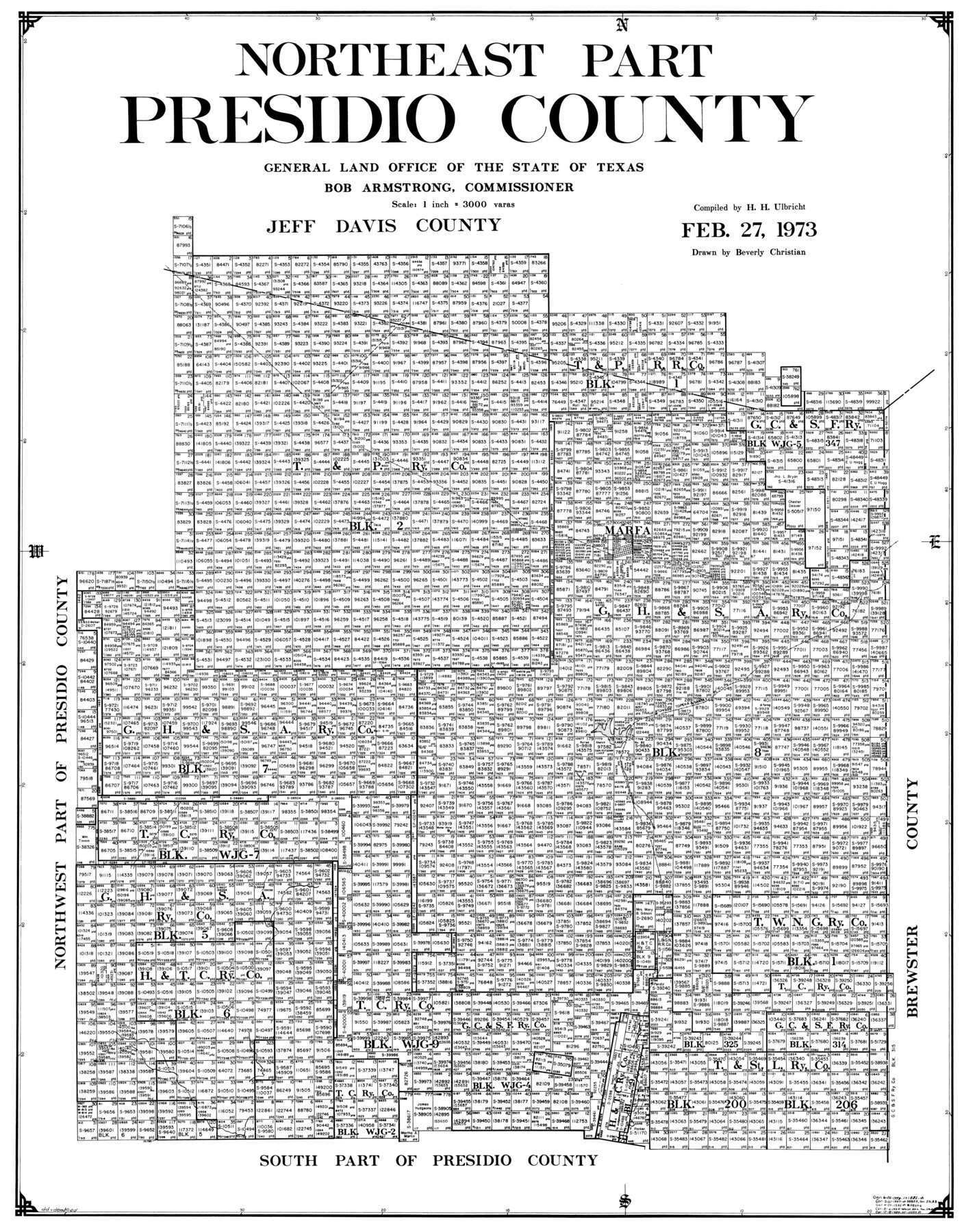
Northeast Part Presidio County
-
Map/Doc
77398
-
Collection
General Map Collection
-
Object Dates
1973/2/27 (Creation Date)
-
People and Organizations
Beverly Christian (Draftsman)
Herbert H. Ulbricht (Compiler)
-
Counties
Presidio
-
Subjects
County
-
Height x Width
39.6 x 31.3 inches
100.6 x 79.5 cm
Part of: General Map Collection
Brewster County Working Sketch 68

Print $20.00
- Digital $50.00
Brewster County Working Sketch 68
1958
Size 23.3 x 22.6 inches
Map/Doc 67669
Hardin County Sketch File 5a

Print $6.00
- Digital $50.00
Hardin County Sketch File 5a
Size 8.1 x 3.5 inches
Map/Doc 25094
Mills County Boundary File 5

Print $8.00
- Digital $50.00
Mills County Boundary File 5
Size 14.2 x 8.7 inches
Map/Doc 57296
Callahan County Sketch File 10b

Print $6.00
- Digital $50.00
Callahan County Sketch File 10b
Size 12.1 x 10.8 inches
Map/Doc 35883
Flight Mission No. CRC-3R, Frame 40, Chambers County

Print $20.00
- Digital $50.00
Flight Mission No. CRC-3R, Frame 40, Chambers County
1956
Size 18.6 x 22.3 inches
Map/Doc 84813
Flight Mission No. BRA-8M, Frame 78, Jefferson County

Print $20.00
- Digital $50.00
Flight Mission No. BRA-8M, Frame 78, Jefferson County
1953
Size 15.9 x 15.8 inches
Map/Doc 85598
Flight Mission No. DIX-10P, Frame 62, Aransas County

Print $20.00
- Digital $50.00
Flight Mission No. DIX-10P, Frame 62, Aransas County
1956
Size 18.8 x 22.4 inches
Map/Doc 83923
Flight Mission No. DAG-19K, Frame 66, Matagorda County

Print $20.00
- Digital $50.00
Flight Mission No. DAG-19K, Frame 66, Matagorda County
1952
Size 16.3 x 16.3 inches
Map/Doc 86393
Duval County Boundary File 3j

Print $12.00
- Digital $50.00
Duval County Boundary File 3j
Size 12.8 x 8.0 inches
Map/Doc 52753
Erath County Sketch File A2

Print $20.00
- Digital $50.00
Erath County Sketch File A2
Size 15.9 x 19.5 inches
Map/Doc 11464
Webb County Boundary File 5

Print $165.00
- Digital $50.00
Webb County Boundary File 5
Size 14.2 x 8.8 inches
Map/Doc 59765
Montague County Sketch File 16

Print $20.00
- Digital $50.00
Montague County Sketch File 16
1853
Size 32.5 x 29.2 inches
Map/Doc 10546
You may also like
Flight Mission No. BRA-6M, Frame 149, Jefferson County

Print $20.00
- Digital $50.00
Flight Mission No. BRA-6M, Frame 149, Jefferson County
1953
Size 18.5 x 22.3 inches
Map/Doc 85450
Montgomery County Working Sketch 50

Print $20.00
- Digital $50.00
Montgomery County Working Sketch 50
1959
Size 25.3 x 21.9 inches
Map/Doc 71157
Schleicher County Sketch File 38

Print $20.00
- Digital $50.00
Schleicher County Sketch File 38
Size 19.1 x 21.7 inches
Map/Doc 12311
Map representing the surveys made in Bexar County

Print $40.00
- Digital $50.00
Map representing the surveys made in Bexar County
1839
Size 75.7 x 37.9 inches
Map/Doc 93364
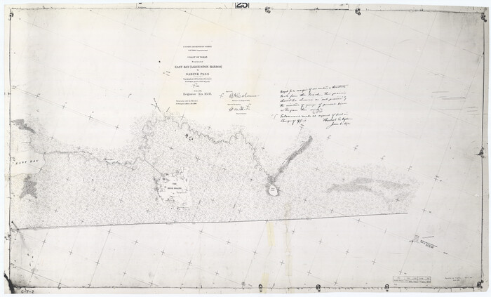
Coast of Texas from head of East Bay Galveston Harbor to Sabine Pass
Print $40.00
- Digital $50.00
Coast of Texas from head of East Bay Galveston Harbor to Sabine Pass
1882
Size 32.6 x 54.1 inches
Map/Doc 69838
Dawson County

Print $20.00
- Digital $50.00
Dawson County
1892
Size 27.1 x 23.3 inches
Map/Doc 66797
Map of Kerr County, Texas

Print $20.00
- Digital $50.00
Map of Kerr County, Texas
1879
Size 21.7 x 28.5 inches
Map/Doc 526
Webb County Rolled Sketch 66

Print $20.00
- Digital $50.00
Webb County Rolled Sketch 66
1957
Size 31.9 x 21.8 inches
Map/Doc 8215
Evans Subdivision Number 2

Print $20.00
- Digital $50.00
Evans Subdivision Number 2
Size 23.9 x 19.4 inches
Map/Doc 92497
Maps & Lists Showing Prison Lands (Oil & Gas) Leased as of June 1955

Digital $50.00
Maps & Lists Showing Prison Lands (Oil & Gas) Leased as of June 1955
Size 11.4 x 7.1 inches
Map/Doc 62866
Flight Mission No. BRA-16M, Frame 164, Jefferson County

Print $20.00
- Digital $50.00
Flight Mission No. BRA-16M, Frame 164, Jefferson County
1953
Size 18.7 x 22.3 inches
Map/Doc 85762
Menard County Rolled Sketch 6

Print $20.00
- Digital $50.00
Menard County Rolled Sketch 6
Size 17.3 x 21.2 inches
Map/Doc 6755