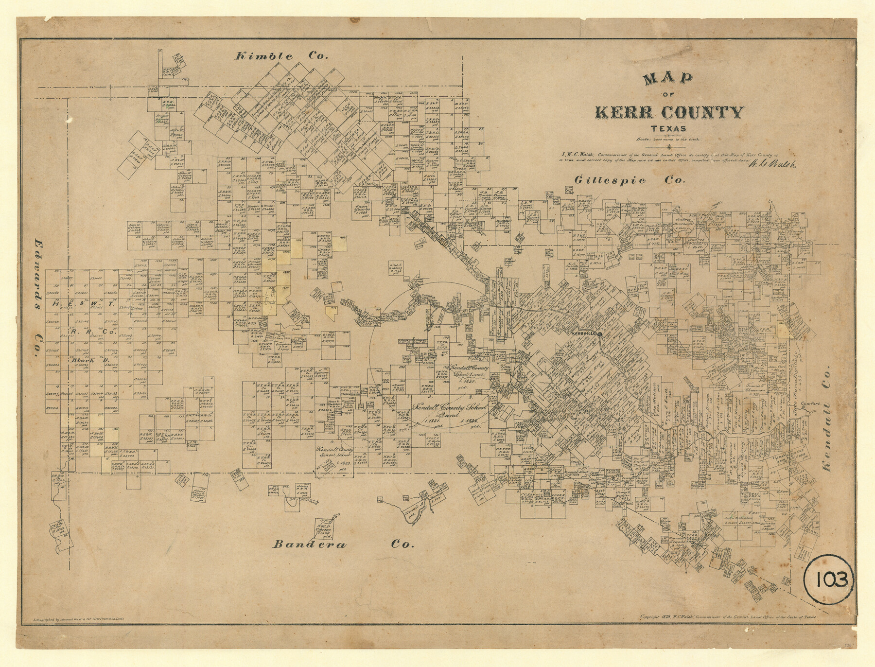
Map of Kerr County, Texas
-
Map/Doc
526
-
Collection
Maddox Collection
-
Object Dates
1879 (Creation Date)
1879 (Copyright Date)
-
People and Organizations
General Land Office (Publisher)
August Gast & Co. (Lithographer)
-
Counties
Kerr
-
Subjects
County
-
Height x Width
21.7 x 28.5 inches
55.1 x 72.4 cm
-
Medium
paper, etching/engraving/lithograph
-
Scale
1" = 4000 varas
-
Comments
Conservation funded in 2009.
-
Features
Fall Creek
Wolf Creek
Bear Creek
North Fork of Kelley's Crek
North Creek
Kerrville
Guadalupe River
Frio Trail
Turtle Creek
Verde Creek
Cherry Creek
Comfort
Medina River
South Prong [of Medina River]
North Prong [of Medina River]
Part of: Maddox Collection
Map showing A. & N. W., Raymond Word #3, S.S. Hervey #496, and M. Farley #495 corrected to conform to the judgement in Cause #2888, Travis County District Court, State of Texas versus D. Sullivan, et al

Print $20.00
- Digital $50.00
Map showing A. & N. W., Raymond Word #3, S.S. Hervey #496, and M. Farley #495 corrected to conform to the judgement in Cause #2888, Travis County District Court, State of Texas versus D. Sullivan, et al
1915
Size 18.5 x 30.0 inches
Map/Doc 75812
[Surveying Sketch of Martha G. Morrow, Mary Bigger, et al in Travis County]
![522, [Surveying Sketch of Martha G. Morrow, Mary Bigger, et al in Travis County], Maddox Collection](https://historictexasmaps.com/wmedia_w700/maps/522.tif.jpg)
Print $3.00
- Digital $50.00
[Surveying Sketch of Martha G. Morrow, Mary Bigger, et al in Travis County]
Size 12.4 x 9.6 inches
Map/Doc 522
Sketch compiled from records of Collin County in General Land Office

Print $3.00
- Digital $50.00
Sketch compiled from records of Collin County in General Land Office
1878
Size 11.5 x 13.5 inches
Map/Doc 504
Map of Lavaca County, Texas

Print $20.00
- Digital $50.00
Map of Lavaca County, Texas
1879
Size 22.8 x 25.0 inches
Map/Doc 561
Fayette County, Texas

Print $20.00
- Digital $50.00
Fayette County, Texas
1879
Size 19.9 x 23.0 inches
Map/Doc 419
Map of Bowie County, Texas

Print $20.00
- Digital $50.00
Map of Bowie County, Texas
1879
Size 21.2 x 24.4 inches
Map/Doc 607
Map showing the John B. Pier Survey, Near Houston

Print $3.00
- Digital $50.00
Map showing the John B. Pier Survey, Near Houston
Size 11.9 x 17.8 inches
Map/Doc 478
Baylor County, Texas

Print $20.00
- Digital $50.00
Baylor County, Texas
1879
Size 22.2 x 17.4 inches
Map/Doc 586
Bell County, Texas

Print $20.00
- Digital $50.00
Bell County, Texas
1879
Size 23.7 x 29.0 inches
Map/Doc 516
Sketch of Survey 3, Block 1 in Dickens and King Counties

Print $20.00
- Digital $50.00
Sketch of Survey 3, Block 1 in Dickens and King Counties
1914
Size 10.8 x 28.2 inches
Map/Doc 10766
Map of Brazos County, Texas

Print $20.00
- Digital $50.00
Map of Brazos County, Texas
1879
Size 21.6 x 15.3 inches
Map/Doc 597
Austin, Texas Congress Ave. Drainage

Print $20.00
- Digital $50.00
Austin, Texas Congress Ave. Drainage
1903
Size 15.3 x 15.4 inches
Map/Doc 75798
You may also like
Young County Sketch File 8

Print $20.00
- Digital $50.00
Young County Sketch File 8
1856
Size 19.8 x 17.7 inches
Map/Doc 12710
Gaines County Working Sketch 27

Print $20.00
- Digital $50.00
Gaines County Working Sketch 27
Size 17.4 x 36.7 inches
Map/Doc 69327
Southern Part of Laguna Madre

Print $20.00
- Digital $50.00
Southern Part of Laguna Madre
1985
Size 45.3 x 36.6 inches
Map/Doc 73547
[United States]
![97197, [United States], General Map Collection](https://historictexasmaps.com/wmedia_w700/maps/97197.tif.jpg)
Print $20.00
- Digital $50.00
[United States]
1848
Size 17.7 x 37.4 inches
Map/Doc 97197
Hudspeth County Working Sketch 8

Print $20.00
- Digital $50.00
Hudspeth County Working Sketch 8
1939
Size 27.3 x 33.1 inches
Map/Doc 66289
County of Galveston, Texas

Print $20.00
- Digital $50.00
County of Galveston, Texas
1845
Size 22.9 x 32.2 inches
Map/Doc 3574
Bexar County Rolled Sketch 4A

Print $20.00
- Digital $50.00
Bexar County Rolled Sketch 4A
1982
Size 24.4 x 36.7 inches
Map/Doc 5138
W. M. Kuykendall Ranch, Matagorda County, Texas

Print $20.00
- Digital $50.00
W. M. Kuykendall Ranch, Matagorda County, Texas
1926
Size 24.3 x 39.6 inches
Map/Doc 3028
Atascosa County Working Sketch 10

Print $20.00
- Digital $50.00
Atascosa County Working Sketch 10
1919
Size 26.2 x 22.3 inches
Map/Doc 67206
Map of Retrieve Plantation, Brazoria County, Texas

Print $20.00
- Digital $50.00
Map of Retrieve Plantation, Brazoria County, Texas
Size 26.6 x 28.5 inches
Map/Doc 62999
[Sketch of part of Blks. B5, 6, 2Z, M6, M8, M11 and M15]
![89644, [Sketch of part of Blks. B5, 6, 2Z, M6, M8, M11 and M15], Twichell Survey Records](https://historictexasmaps.com/wmedia_w700/maps/89644-1.tif.jpg)
Print $40.00
- Digital $50.00
[Sketch of part of Blks. B5, 6, 2Z, M6, M8, M11 and M15]
Size 18.6 x 62.0 inches
Map/Doc 89644
Flight Mission No. DQN-3K, Frame 65, Calhoun County

Print $20.00
- Digital $50.00
Flight Mission No. DQN-3K, Frame 65, Calhoun County
1953
Size 16.2 x 16.1 inches
Map/Doc 84356