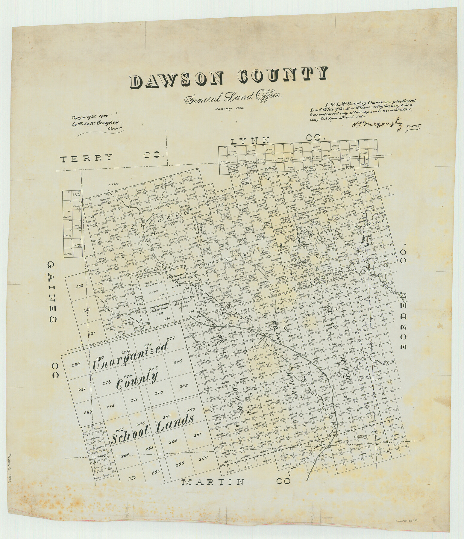
Dawson County
-
Map/Doc
66797
-
Collection
General Map Collection
-
Object Dates
1892 (Creation Date)
-
People and Organizations
Texas General Land Office (Publisher)
W.L. McGaughey (GLO Commissioner)
-
Counties
Dawson
-
Subjects
County
-
Height x Width
27.1 x 23.3 inches
68.8 x 59.2 cm
Part of: General Map Collection
Lamb County Sketch File 10

Print $22.00
- Digital $50.00
Lamb County Sketch File 10
1912
Size 20.0 x 31.2 inches
Map/Doc 11972
Hardin County Sketch File 27

Print $4.00
- Digital $50.00
Hardin County Sketch File 27
Size 13.0 x 8.1 inches
Map/Doc 25151
Liberty County Sketch File 33a

Print $4.00
- Digital $50.00
Liberty County Sketch File 33a
1874
Size 7.9 x 8.2 inches
Map/Doc 29969
Kimble County Working Sketch 27

Print $20.00
- Digital $50.00
Kimble County Working Sketch 27
1934
Size 16.1 x 17.3 inches
Map/Doc 70095
Anderson County Sketch File 20

Print $6.00
- Digital $50.00
Anderson County Sketch File 20
1852
Size 8.6 x 6.5 inches
Map/Doc 12791
Scurry County Rolled Sketch 2

Print $20.00
- Digital $50.00
Scurry County Rolled Sketch 2
Size 44.0 x 44.9 inches
Map/Doc 9911
Flight Mission No. BRA-8M, Frame 132, Jefferson County

Print $20.00
- Digital $50.00
Flight Mission No. BRA-8M, Frame 132, Jefferson County
1953
Size 18.7 x 22.3 inches
Map/Doc 85628
Trinity County Sketch File 5a

Print $4.00
- Digital $50.00
Trinity County Sketch File 5a
1853
Size 6.9 x 8.0 inches
Map/Doc 38504
Upton County Working Sketch Graphic Index, Sheet 1 (Sketches 1 to 39)

Print $40.00
- Digital $50.00
Upton County Working Sketch Graphic Index, Sheet 1 (Sketches 1 to 39)
1969
Size 49.9 x 37.0 inches
Map/Doc 76721
[Sketch for Mineral Application 17237 / Mineral File 11855 - Neches River, Joe A. Sanders]
![65687, [Sketch for Mineral Application 17237 / Mineral File 11855 - Neches River, Joe A. Sanders], General Map Collection](https://historictexasmaps.com/wmedia_w700/maps/65687.tif.jpg)
Print $40.00
- Digital $50.00
[Sketch for Mineral Application 17237 / Mineral File 11855 - Neches River, Joe A. Sanders]
1927
Size 78.5 x 31.2 inches
Map/Doc 65687
[Surveys in the Milam District on Bosque River and Spring Creek]
![3170, [Surveys in the Milam District on Bosque River and Spring Creek], General Map Collection](https://historictexasmaps.com/wmedia_w700/maps/3170.tif.jpg)
Print $20.00
- Digital $50.00
[Surveys in the Milam District on Bosque River and Spring Creek]
1846
Size 13.3 x 14.7 inches
Map/Doc 3170
Dallas County Sketch File 19 1/2

Print $4.00
- Digital $50.00
Dallas County Sketch File 19 1/2
Size 9.9 x 8.2 inches
Map/Doc 20439
You may also like
Monterey Harbor, California

Print $20.00
- Digital $50.00
Monterey Harbor, California
1852
Size 15.7 x 13.8 inches
Map/Doc 97230
General Highway Map, Nueces County, Texas

Print $20.00
General Highway Map, Nueces County, Texas
1940
Size 24.6 x 18.4 inches
Map/Doc 79210
Wheeler County Working Sketch 8

Print $40.00
- Digital $50.00
Wheeler County Working Sketch 8
1972
Size 59.4 x 42.0 inches
Map/Doc 72497
Grayson County Sketch File 4

Print $4.00
- Digital $50.00
Grayson County Sketch File 4
1856
Size 12.5 x 8.2 inches
Map/Doc 24462
Township 3 North Range 14 West, North Western District, Louisiana

Print $20.00
- Digital $50.00
Township 3 North Range 14 West, North Western District, Louisiana
1844
Size 19.8 x 24.7 inches
Map/Doc 65862
Working Sketch in Bastrop County

Print $20.00
- Digital $50.00
Working Sketch in Bastrop County
1921
Size 14.4 x 22.9 inches
Map/Doc 90205
Flight Mission No. CGI-4N, Frame 24, Cameron County

Print $20.00
- Digital $50.00
Flight Mission No. CGI-4N, Frame 24, Cameron County
1954
Size 18.6 x 22.3 inches
Map/Doc 84657
[Galveston, Harrisburg & San Antonio through El Paso County]
![64004, [Galveston, Harrisburg & San Antonio through El Paso County], General Map Collection](https://historictexasmaps.com/wmedia_w700/maps/64004.tif.jpg)
Print $20.00
- Digital $50.00
[Galveston, Harrisburg & San Antonio through El Paso County]
Size 13.6 x 33.6 inches
Map/Doc 64004
La Salle County Rolled Sketch 6A

Print $40.00
- Digital $50.00
La Salle County Rolled Sketch 6A
1941
Size 43.5 x 68.2 inches
Map/Doc 10729
Leon County Rolled Sketch 34

Print $20.00
- Digital $50.00
Leon County Rolled Sketch 34
1999
Size 31.8 x 37.1 inches
Map/Doc 87502
Presidio County Working Sketch 150

Print $20.00
- Digital $50.00
Presidio County Working Sketch 150
2002
Size 24.0 x 23.5 inches
Map/Doc 93490
Wise County Working Sketch 5

Print $20.00
- Digital $50.00
Wise County Working Sketch 5
1948
Size 25.7 x 23.4 inches
Map/Doc 72619