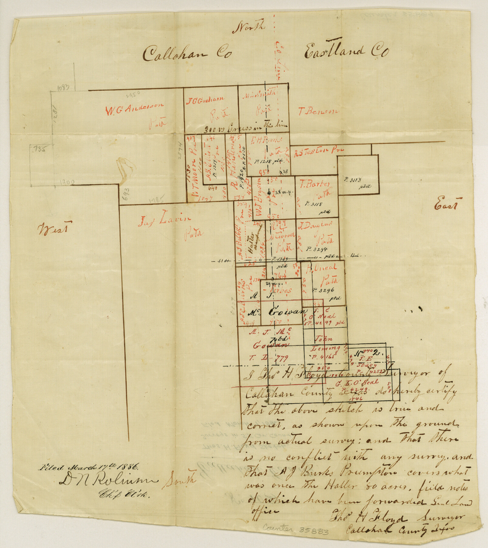
Callahan County Sketch File 10b
[Sketch of surveys near the intersection of Callahan, Eastland, and Brown Counties]
-
Map/Doc
35883
-
Collection
General Map Collection
-
Object Dates
1886/3/17 (File Date)
-
People and Organizations
Thos. H. Floyd (Surveyor/Engineer)
-
Counties
Brown Callahan Eastland
-
Subjects
Surveying Sketch File
-
Height x Width
12.1 x 10.8 inches
30.7 x 27.4 cm
-
Medium
paper, manuscript
Part of: General Map Collection
Orange County Sketch File B

Print $20.00
- Digital $50.00
Orange County Sketch File B
1890
Size 17.6 x 26.0 inches
Map/Doc 12130
Presidio County Rolled Sketch 90

Print $20.00
- Digital $50.00
Presidio County Rolled Sketch 90
1947
Size 20.5 x 24.4 inches
Map/Doc 7375
Matagorda County Sketch File 2

Print $6.00
- Digital $50.00
Matagorda County Sketch File 2
1866
Size 15.9 x 10.8 inches
Map/Doc 30730

Flight Mission No. BRE-1P, Frame 54, Nueces County

Print $20.00
- Digital $50.00
Flight Mission No. BRE-1P, Frame 54, Nueces County
1956
Size 18.4 x 22.2 inches
Map/Doc 86643
Coke County Working Sketch 3

Print $20.00
- Digital $50.00
Coke County Working Sketch 3
1890
Size 22.3 x 29.2 inches
Map/Doc 68040
Missouri Pacific Railway System

Print $20.00
- Digital $50.00
Missouri Pacific Railway System
1888
Size 20.0 x 20.0 inches
Map/Doc 89223
Webb County Sketch File B

Print $20.00
- Digital $50.00
Webb County Sketch File B
Size 15.9 x 13.7 inches
Map/Doc 12605
Flight Mission No. BRA-17M, Frame 7, Jefferson County

Print $20.00
- Digital $50.00
Flight Mission No. BRA-17M, Frame 7, Jefferson County
1953
Size 18.7 x 22.3 inches
Map/Doc 85788
Van Zandt County Sketch File 43

Print $4.00
- Digital $50.00
Van Zandt County Sketch File 43
1874
Size 12.7 x 8.1 inches
Map/Doc 39497
Brewster County Sketch File 18

Print $8.00
- Digital $50.00
Brewster County Sketch File 18
1942
Size 13.8 x 7.6 inches
Map/Doc 15813
Harris County Sketch File 71a

Print $24.00
- Digital $50.00
Harris County Sketch File 71a
1941
Size 11.4 x 8.9 inches
Map/Doc 25525
You may also like
Flight Mission No. BQY-4M, Frame 121, Harris County

Print $20.00
- Digital $50.00
Flight Mission No. BQY-4M, Frame 121, Harris County
1953
Size 18.8 x 22.5 inches
Map/Doc 85289
Shackelford County Sketch File 15

Print $16.00
- Digital $50.00
Shackelford County Sketch File 15
1998
Size 14.2 x 8.8 inches
Map/Doc 62202
Flight Mission No. BQR-4K, Frame 65, Brazoria County

Print $20.00
- Digital $50.00
Flight Mission No. BQR-4K, Frame 65, Brazoria County
1952
Size 18.5 x 22.3 inches
Map/Doc 83998
Pecos County Sketch File 7

Print $20.00
- Digital $50.00
Pecos County Sketch File 7
Size 29.7 x 44.5 inches
Map/Doc 10568
The Republic County of Montgomery. Spring 1842

Print $20.00
The Republic County of Montgomery. Spring 1842
2020
Size 19.9 x 21.7 inches
Map/Doc 96240
Andrews County Working Sketch 9

Print $20.00
- Digital $50.00
Andrews County Working Sketch 9
1955
Size 10.2 x 23.3 inches
Map/Doc 67055
Packery Channel

Print $20.00
- Digital $50.00
Packery Channel
1950
Size 17.6 x 17.5 inches
Map/Doc 2997
Real County Working Sketch 17

Print $20.00
- Digital $50.00
Real County Working Sketch 17
1941
Size 18.8 x 24.3 inches
Map/Doc 71909
Harris County NRC Article 33.136 Sketch 15

Print $28.00
- Digital $50.00
Harris County NRC Article 33.136 Sketch 15
2012
Size 24.0 x 18.0 inches
Map/Doc 94762
Webb County Working Sketch 14

Print $20.00
- Digital $50.00
Webb County Working Sketch 14
1923
Size 19.3 x 32.2 inches
Map/Doc 72379
[F. W. & D. C. Ry. Co. Alignment and Right of Way Map, Clay County]
![64728, [F. W. & D. C. Ry. Co. Alignment and Right of Way Map, Clay County], General Map Collection](https://historictexasmaps.com/wmedia_w700/maps/64728-1.tif.jpg)
Print $20.00
- Digital $50.00
[F. W. & D. C. Ry. Co. Alignment and Right of Way Map, Clay County]
1927
Size 18.8 x 11.7 inches
Map/Doc 64728
East Part of Jeff Davis Co.

Print $20.00
- Digital $50.00
East Part of Jeff Davis Co.
1977
Size 47.9 x 36.9 inches
Map/Doc 95544