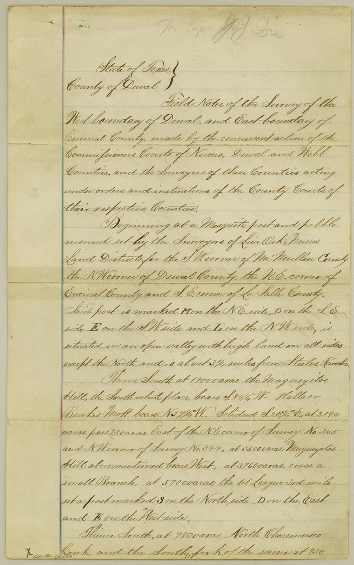
Duval County Boundary File 3j
Fieldnotes of West boundary of Duval County and East boundary of Encinal Co.
-
Map/Doc
52753
-
Collection
General Map Collection
-
Counties
Duval
-
Subjects
County Boundaries
-
Height x Width
12.8 x 8.0 inches
32.5 x 20.3 cm
Part of: General Map Collection
Pecos County Working Sketch 5

Print $20.00
- Digital $50.00
Pecos County Working Sketch 5
1886
Size 22.8 x 19.2 inches
Map/Doc 71475
Flight Mission No. CRC-2R, Frame 118, Chambers County

Print $20.00
- Digital $50.00
Flight Mission No. CRC-2R, Frame 118, Chambers County
1956
Size 18.6 x 21.6 inches
Map/Doc 84742
Hunt County Working Sketch 5

Print $20.00
- Digital $50.00
Hunt County Working Sketch 5
1942
Size 23.8 x 20.2 inches
Map/Doc 66352
Rusk County Sketch File 27B

Print $20.00
Rusk County Sketch File 27B
1936
Size 15.4 x 19.9 inches
Map/Doc 12273
Harris County Rolled Sketch GC

Print $40.00
- Digital $50.00
Harris County Rolled Sketch GC
1917
Size 42.1 x 52.4 inches
Map/Doc 9115
Lake Buchanan, Burnet and Llano Counties, Texas

Print $20.00
- Digital $50.00
Lake Buchanan, Burnet and Llano Counties, Texas
1935
Size 20.7 x 14.4 inches
Map/Doc 3136
Coke County Sketch File 17-18

Print $24.00
- Digital $50.00
Coke County Sketch File 17-18
1902
Size 16.6 x 14.2 inches
Map/Doc 11109
Hudspeth County Sketch File 42

Print $12.00
- Digital $50.00
Hudspeth County Sketch File 42
1982
Size 14.2 x 8.7 inches
Map/Doc 27016

Garza County Sketch File 6

Print $8.00
- Digital $50.00
Garza County Sketch File 6
1900
Size 14.2 x 8.7 inches
Map/Doc 24056
Calhoun County Rolled Sketch 3

Print $20.00
- Digital $50.00
Calhoun County Rolled Sketch 3
Size 28.0 x 21.9 inches
Map/Doc 5361
Clay County Sketch File 44

Print $20.00
- Digital $50.00
Clay County Sketch File 44
Size 24.7 x 36.0 inches
Map/Doc 11096
You may also like
Coast Chart No. 210 Aransas Pass and Corpus Christi Bay with the coast to latitude 27° 12' Texas

Print $20.00
- Digital $50.00
Coast Chart No. 210 Aransas Pass and Corpus Christi Bay with the coast to latitude 27° 12' Texas
1913
Size 27.5 x 18.3 inches
Map/Doc 72799
Southern Pacific Rice Belt

Print $40.00
- Digital $50.00
Southern Pacific Rice Belt
Size 31.6 x 57.9 inches
Map/Doc 96793
Donley County Sketch File 6

Print $16.00
- Digital $50.00
Donley County Sketch File 6
1881
Size 12.9 x 8.5 inches
Map/Doc 21230
La Salle County Working Sketch 39

Print $20.00
- Digital $50.00
La Salle County Working Sketch 39
1963
Size 30.4 x 25.4 inches
Map/Doc 70340
West and Trans-Pecos Texas with parts of New Mexico and Mexico and a New Map of Big Bend Ranch State Park and Surrounding Area

Print $32.48
West and Trans-Pecos Texas with parts of New Mexico and Mexico and a New Map of Big Bend Ranch State Park and Surrounding Area
1988
Size 28.0 x 31.0 inches
Map/Doc 89070
Bastrop County Working Sketch 6

Print $20.00
- Digital $50.00
Bastrop County Working Sketch 6
1923
Size 37.5 x 31.2 inches
Map/Doc 67306
Calhoun County Working Sketch 7

Print $20.00
- Digital $50.00
Calhoun County Working Sketch 7
1943
Size 20.1 x 22.0 inches
Map/Doc 67823
North Part Brewster Co.

Print $20.00
- Digital $50.00
North Part Brewster Co.
1904
Size 37.0 x 46.9 inches
Map/Doc 66727
Map of subdivision of submerged land in the Gulf of Mexico fronting on Matagorda Island and Peninsula

Print $40.00
- Digital $50.00
Map of subdivision of submerged land in the Gulf of Mexico fronting on Matagorda Island and Peninsula
1940
Size 28.2 x 61.3 inches
Map/Doc 2929
Mills County Rolled Sketch 6

Print $20.00
- Digital $50.00
Mills County Rolled Sketch 6
2007
Size 24.4 x 36.6 inches
Map/Doc 88738
Map of a Part of Lea County, New Mexico

Print $40.00
- Digital $50.00
Map of a Part of Lea County, New Mexico
Size 60.5 x 42.0 inches
Map/Doc 89910
Palo Pinto County Working Sketch 19

Print $40.00
- Digital $50.00
Palo Pinto County Working Sketch 19
1975
Size 34.0 x 55.5 inches
Map/Doc 71402