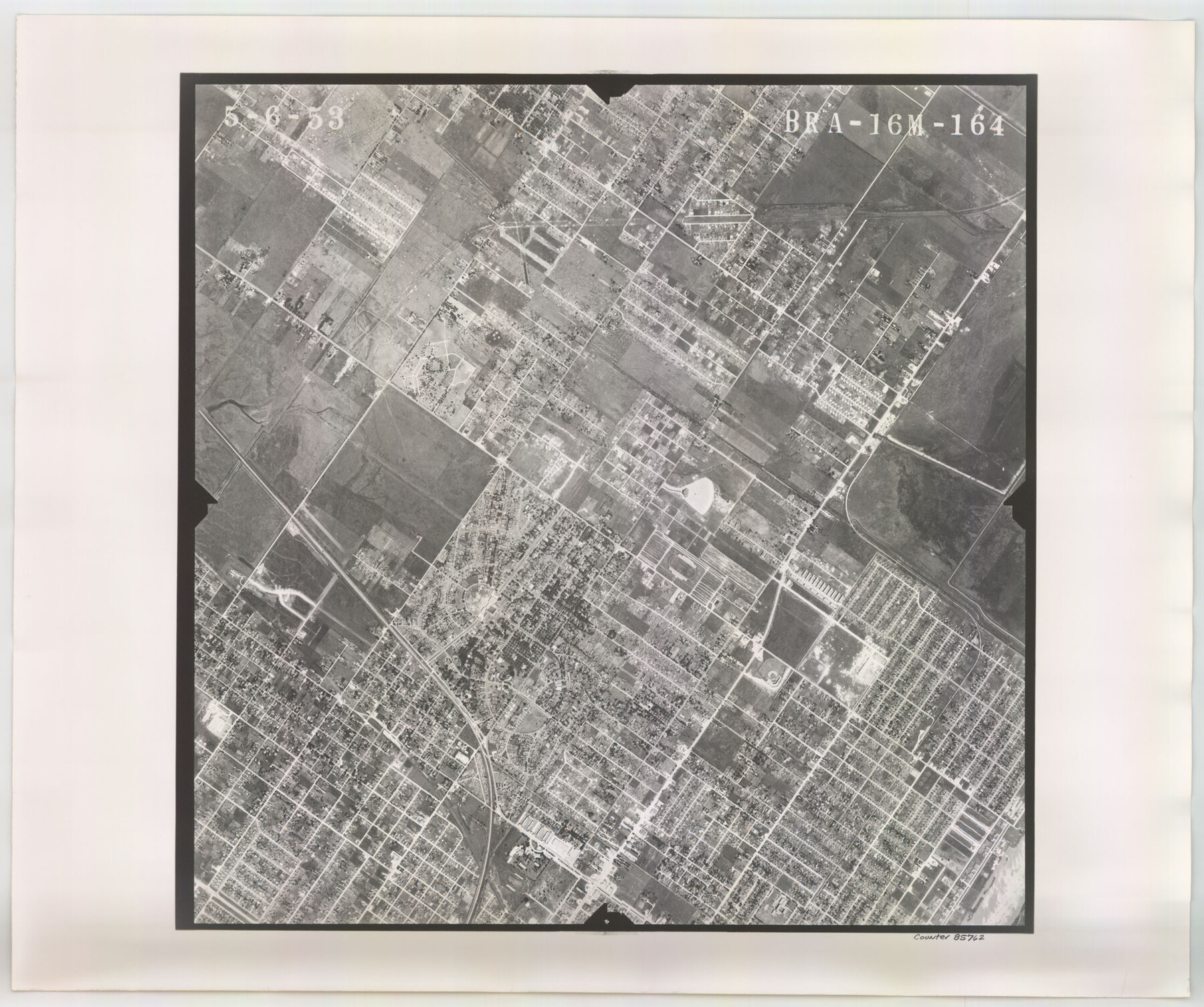
Flight Mission No. BRA-16M, Frame 164, Jefferson County
BRA-16M-164
-
Map/Doc
85762
-
Collection
General Map Collection
-
Object Dates
1953/5/6 (Creation Date)
-
People and Organizations
U. S. Department of Agriculture (Publisher)
-
Counties
Jefferson
-
Subjects
Aerial Photograph
-
Height x Width
18.7 x 22.3 inches
47.5 x 56.6 cm
-
Comments
Flown by Jack Ammann Photogrammetric Engineers of San Antonio, Texas.
Part of: General Map Collection
Colorado County Working Sketch 18

Print $20.00
- Digital $50.00
Colorado County Working Sketch 18
1957
Size 31.2 x 37.3 inches
Map/Doc 68118

Morris County Rolled Sketch 2A

Print $20.00
- Digital $50.00
Morris County Rolled Sketch 2A
Size 24.0 x 18.8 inches
Map/Doc 10252
Real County Rolled Sketch 6

Print $20.00
- Digital $50.00
Real County Rolled Sketch 6
Size 28.0 x 23.7 inches
Map/Doc 7456
Van Zandt County Sketch File 21

Print $4.00
- Digital $50.00
Van Zandt County Sketch File 21
1858
Size 12.1 x 7.7 inches
Map/Doc 39430
Wilbarger County Rolled Sketch 8

Print $20.00
- Digital $50.00
Wilbarger County Rolled Sketch 8
1965
Size 22.0 x 18.9 inches
Map/Doc 8257
Flight Mission No. DQN-3K, Frame 4, Calhoun County

Print $20.00
- Digital $50.00
Flight Mission No. DQN-3K, Frame 4, Calhoun County
1953
Size 17.0 x 18.9 inches
Map/Doc 84336
Montgomery County Rolled Sketch 45

Print $20.00
- Digital $50.00
Montgomery County Rolled Sketch 45
2006
Size 20.5 x 31.3 inches
Map/Doc 85242
[Map of Block 97, Borden and Scurry Co (Exhibit A); Map of Southeastern part of Young Territory; Map of part of of Borden, Fisher, Kent, Mitchell, Scurry and Garza Cos. Showing the north boundary line of the T&P 80 mile reservation]
![65693, [Map of Block 97, Borden and Scurry Co (Exhibit A); Map of Southeastern part of Young Territory; Map of part of of Borden, Fisher, Kent, Mitchell, Scurry and Garza Cos. Showing the north boundary line of the T&P 80 mile reservation], General Map Collection](https://historictexasmaps.com/wmedia_w700/maps/65693.tif.jpg)
Print $20.00
- Digital $50.00
[Map of Block 97, Borden and Scurry Co (Exhibit A); Map of Southeastern part of Young Territory; Map of part of of Borden, Fisher, Kent, Mitchell, Scurry and Garza Cos. Showing the north boundary line of the T&P 80 mile reservation]
1901
Size 31.2 x 23.3 inches
Map/Doc 65693
Burleson County Working Sketch 40

Print $20.00
- Digital $50.00
Burleson County Working Sketch 40
1986
Size 23.1 x 27.9 inches
Map/Doc 67759
Upton County Working Sketch 57

Print $20.00
- Digital $50.00
Upton County Working Sketch 57
1988
Size 28.9 x 37.4 inches
Map/Doc 69554
Floyd County Working Sketch 1

Print $20.00
- Digital $50.00
Floyd County Working Sketch 1
1949
Size 24.5 x 24.1 inches
Map/Doc 69180
You may also like
Brazoria County Rolled Sketch 34

Print $20.00
- Digital $50.00
Brazoria County Rolled Sketch 34
1944
Size 29.8 x 18.3 inches
Map/Doc 5171
Flight Mission No. CRC-1R, Frame 94, Chambers County

Print $20.00
- Digital $50.00
Flight Mission No. CRC-1R, Frame 94, Chambers County
1956
Size 18.8 x 22.5 inches
Map/Doc 84709
[Block 1 and vicinity]
![90703, [Block 1 and vicinity], Twichell Survey Records](https://historictexasmaps.com/wmedia_w700/maps/90703-1.tif.jpg)
Print $20.00
- Digital $50.00
[Block 1 and vicinity]
Size 25.3 x 24.1 inches
Map/Doc 90703
Harris County Rolled Sketch 88

Print $20.00
- Digital $50.00
Harris County Rolled Sketch 88
1937
Size 34.9 x 22.7 inches
Map/Doc 6126
Henderson County Working Sketch 22

Print $20.00
- Digital $50.00
Henderson County Working Sketch 22
1951
Size 26.5 x 31.2 inches
Map/Doc 66155
[Surveys near Calaveras Creek]
![364, [Surveys near Calaveras Creek], General Map Collection](https://historictexasmaps.com/wmedia_w700/maps/364.tif.jpg)
Print $2.00
- Digital $50.00
[Surveys near Calaveras Creek]
1846
Size 10.9 x 8.0 inches
Map/Doc 364
Cass County Working Sketch 34

Print $20.00
- Digital $50.00
Cass County Working Sketch 34
1982
Size 21.1 x 24.6 inches
Map/Doc 67937
Bandera County Rolled Sketch 13

Print $20.00
- Digital $50.00
Bandera County Rolled Sketch 13
2018
Size 25.0 x 20.7 inches
Map/Doc 95304
Harris County Working Sketch 70

Print $20.00
- Digital $50.00
Harris County Working Sketch 70
1956
Size 25.5 x 32.9 inches
Map/Doc 65962
Guadalupe County Sketch File 15f

Print $10.00
- Digital $50.00
Guadalupe County Sketch File 15f
Size 12.7 x 8.2 inches
Map/Doc 24710
Childress County Rolled Sketch 9D

Print $3.00
- Digital $50.00
Childress County Rolled Sketch 9D
1945
Size 16.0 x 10.0 inches
Map/Doc 78221
Map of Texas with population and location of principal towns and cities according to latest reliable statistics

Print $20.00
- Digital $50.00
Map of Texas with population and location of principal towns and cities according to latest reliable statistics
1910
Size 19.1 x 20.6 inches
Map/Doc 95878