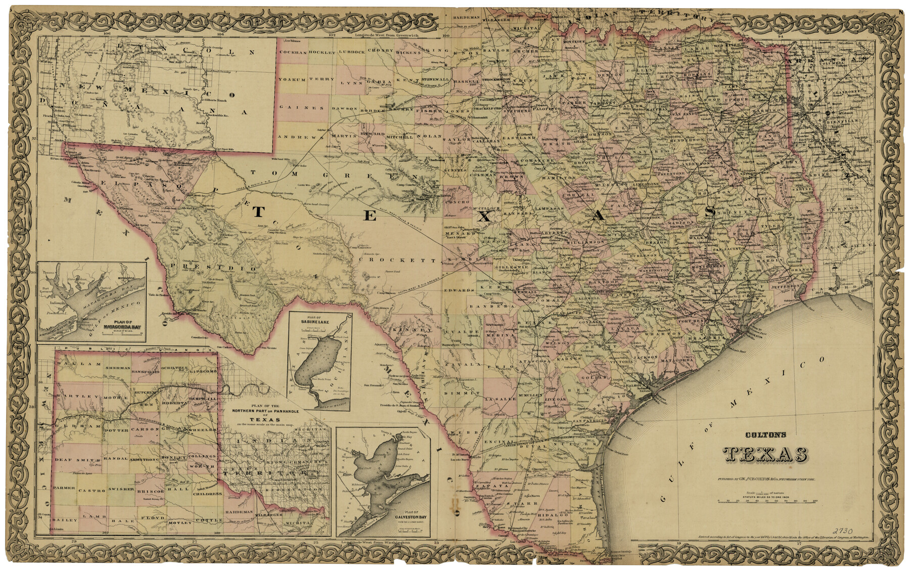
Colton's Texas
-
Map/Doc
76278
-
Collection
Texas State Library and Archives
-
Object Dates
1873 (Creation Date)
-
People and Organizations
G. W. and C. B. Colton and Company (Publisher)
-
Subjects
State of Texas
-
Height x Width
17.5 x 28.2 inches
44.5 x 71.6 cm
-
Comments
Prints available courtesy of the Texas State Library and Archives.
More info can be found here: TSLAC Map 02730
Part of: Texas State Library and Archives
General Highway Map, Atascosa County, Texas

Print $20.00
General Highway Map, Atascosa County, Texas
1940
Size 18.2 x 24.9 inches
Map/Doc 79008
General Highway Map, Lamb County, Texas

Print $20.00
General Highway Map, Lamb County, Texas
1961
Size 24.5 x 18.2 inches
Map/Doc 79562
General Highway Map, Freestone County, Texas

Print $20.00
General Highway Map, Freestone County, Texas
1961
Size 18.1 x 24.8 inches
Map/Doc 79472
General Highway Map, Nueces County, Texas

Print $20.00
General Highway Map, Nueces County, Texas
1961
Size 24.9 x 18.4 inches
Map/Doc 79615
General Highway Map, King County, Texas

Print $20.00
General Highway Map, King County, Texas
1940
Size 18.3 x 24.8 inches
Map/Doc 79161
General Highway Map, Panola County, Texas

Print $20.00
General Highway Map, Panola County, Texas
1940
Size 18.2 x 24.6 inches
Map/Doc 79214
General Highway Map, Caldwell County, Texas

Print $20.00
General Highway Map, Caldwell County, Texas
1961
Size 18.3 x 24.6 inches
Map/Doc 79394
General Highway Map, Camp County, Morris County, Titus County, Texas

Print $20.00
General Highway Map, Camp County, Morris County, Titus County, Texas
1961
Size 24.7 x 18.1 inches
Map/Doc 79400
General Highway Map, Harris County, Texas

Print $20.00
General Highway Map, Harris County, Texas
1961
Size 24.9 x 18.0 inches
Map/Doc 79502
Mexico and Internal Provinces

Print $20.00
Mexico and Internal Provinces
1829
Size 12.9 x 14.5 inches
Map/Doc 79733
General Highway Map, Clay County, Texas

Print $20.00
General Highway Map, Clay County, Texas
1961
Size 24.8 x 18.2 inches
Map/Doc 79409
Rand McNally Main Highway Map of Texas

Print $20.00
Rand McNally Main Highway Map of Texas
1923
Size 27.7 x 40.3 inches
Map/Doc 76260
You may also like
[San Antonio & Aransas Pass]
![64208, [San Antonio & Aransas Pass], General Map Collection](https://historictexasmaps.com/wmedia_w700/maps/64208.tif.jpg)
Print $40.00
- Digital $50.00
[San Antonio & Aransas Pass]
Size 17.0 x 50.7 inches
Map/Doc 64208
Map showing survey for proposed ship channel from Brownsville to Brazos Santiago Pass

Print $20.00
- Digital $50.00
Map showing survey for proposed ship channel from Brownsville to Brazos Santiago Pass
1912
Size 18.1 x 28.0 inches
Map/Doc 72899
Map of Cherokee County, Texas

Print $20.00
- Digital $50.00
Map of Cherokee County, Texas
1879
Size 30.8 x 24.0 inches
Map/Doc 696
Map showing lands surveyed by Sylvan Sanders in the Southwestern Part of Jack County, Texas for Buttram Petroleum Corporation

Print $20.00
- Digital $50.00
Map showing lands surveyed by Sylvan Sanders in the Southwestern Part of Jack County, Texas for Buttram Petroleum Corporation
1926
Size 29.3 x 25.6 inches
Map/Doc 92159
Brewster County Working Sketch 72

Print $20.00
- Digital $50.00
Brewster County Working Sketch 72
1965
Size 20.7 x 24.6 inches
Map/Doc 67672
Flight Mission No. DCL-6C, Frame 49, Kenedy County

Print $20.00
- Digital $50.00
Flight Mission No. DCL-6C, Frame 49, Kenedy County
1943
Size 18.6 x 22.5 inches
Map/Doc 85891
Starr County Sketch File 51

Print $22.00
- Digital $50.00
Starr County Sketch File 51
1967
Size 12.2 x 15.6 inches
Map/Doc 37009

San Jacinto County Sketch File 21

Print $2.00
San Jacinto County Sketch File 21
1873
Size 10.4 x 8.4 inches
Map/Doc 35802
Galveston County Sketch File 75

Print $12.00
- Digital $50.00
Galveston County Sketch File 75
2011
Size 11.0 x 8.5 inches
Map/Doc 95180
Flight Mission No. BRA-3M, Frame 195, Jefferson County

Print $20.00
- Digital $50.00
Flight Mission No. BRA-3M, Frame 195, Jefferson County
1953
Size 18.6 x 22.3 inches
Map/Doc 85410
Val Verde County Sketch File 33

Print $40.00
- Digital $50.00
Val Verde County Sketch File 33
Size 17.5 x 13.9 inches
Map/Doc 39249