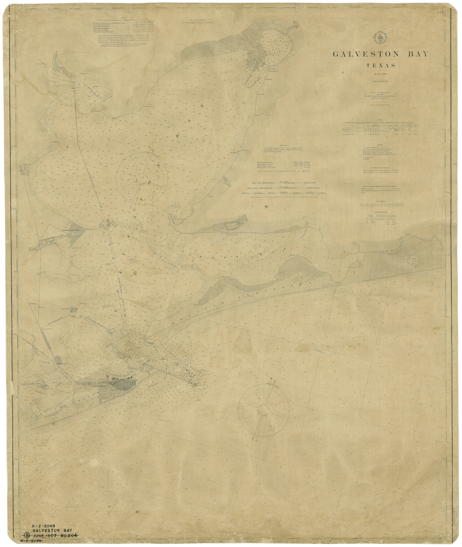
Galveston Bay
K-2-204b
-
Map/Doc
69871
-
Collection
General Map Collection
-
Object Dates
1907 (Creation Date)
-
Counties
Galveston Chambers Harris
-
Subjects
Nautical Charts
-
Height x Width
40.6 x 34.4 inches
103.1 x 87.4 cm
Part of: General Map Collection
Bee County Sketch File 20

Print $8.00
- Digital $50.00
Bee County Sketch File 20
1861
Size 14.3 x 8.8 inches
Map/Doc 14308
Tom Green County

Print $40.00
- Digital $50.00
Tom Green County
1942
Size 55.4 x 47.6 inches
Map/Doc 63073

Newton County Working Sketch 40

Print $20.00
- Digital $50.00
Newton County Working Sketch 40
1970
Size 43.6 x 39.7 inches
Map/Doc 71286
Rockwall County

Print $20.00
- Digital $50.00
Rockwall County
1941
Size 28.7 x 23.0 inches
Map/Doc 73277
San Patricio County Sketch File 31

Print $6.00
- Digital $50.00
San Patricio County Sketch File 31
Size 14.0 x 10.0 inches
Map/Doc 36117
Menard County Working Sketch 10

Print $20.00
- Digital $50.00
Menard County Working Sketch 10
1938
Size 21.8 x 18.5 inches
Map/Doc 70957
Midland County Working Sketch 27

Print $20.00
- Digital $50.00
Midland County Working Sketch 27
1963
Size 41.6 x 38.9 inches
Map/Doc 71008
Stephens County

Print $20.00
- Digital $50.00
Stephens County
1940
Size 42.5 x 40.4 inches
Map/Doc 73293
Flight Mission No. DCL-7C, Frame 109, Kenedy County

Print $20.00
- Digital $50.00
Flight Mission No. DCL-7C, Frame 109, Kenedy County
1943
Size 18.6 x 22.2 inches
Map/Doc 86074
Culberson County Rolled Sketch 33

Print $20.00
- Digital $50.00
Culberson County Rolled Sketch 33
1937
Size 36.4 x 27.9 inches
Map/Doc 5658
Dimmit County Sketch File 22

Print $47.00
- Digital $50.00
Dimmit County Sketch File 22
1906
Size 9.3 x 8.6 inches
Map/Doc 21129
You may also like
Bell County Sketch File 8

Print $4.00
- Digital $50.00
Bell County Sketch File 8
1852
Size 14.2 x 8.9 inches
Map/Doc 14377
La Salle County Working Sketch 25

Print $20.00
- Digital $50.00
La Salle County Working Sketch 25
1947
Size 32.8 x 41.0 inches
Map/Doc 70326
Aransas County Rolled Sketch 3

Print $20.00
- Digital $50.00
Aransas County Rolled Sketch 3
Size 20.9 x 26.5 inches
Map/Doc 77188
Limestone County Working Sketch 8

Print $20.00
- Digital $50.00
Limestone County Working Sketch 8
1922
Size 30.6 x 18.4 inches
Map/Doc 70558
Howard County

Print $20.00
- Digital $50.00
Howard County
1922
Size 40.3 x 34.6 inches
Map/Doc 77318
Panola County Sketch File 30

Print $4.00
- Digital $50.00
Panola County Sketch File 30
1944
Size 2.8 x 8.9 inches
Map/Doc 33505
Galveston County Sketch File 30

Print $20.00
- Digital $50.00
Galveston County Sketch File 30
1915
Size 43.0 x 30.7 inches
Map/Doc 10455
Garza County Boundary File 2

Print $6.00
- Digital $50.00
Garza County Boundary File 2
Size 14.9 x 9.2 inches
Map/Doc 53673
Flight Mission No. CRC-4R, Frame 174, Chambers County

Print $20.00
- Digital $50.00
Flight Mission No. CRC-4R, Frame 174, Chambers County
1956
Size 18.6 x 22.3 inches
Map/Doc 84925
Navarro County Rolled Sketch 7

Print $20.00
- Digital $50.00
Navarro County Rolled Sketch 7
Size 45.0 x 34.6 inches
Map/Doc 10308
Throckmorton County Boundary File 6

Print $6.00
- Digital $50.00
Throckmorton County Boundary File 6
Size 11.4 x 8.9 inches
Map/Doc 59292
Galveston County Rolled Sketch 22

Print $20.00
- Digital $50.00
Galveston County Rolled Sketch 22
1953
Size 28.8 x 39.5 inches
Map/Doc 9663