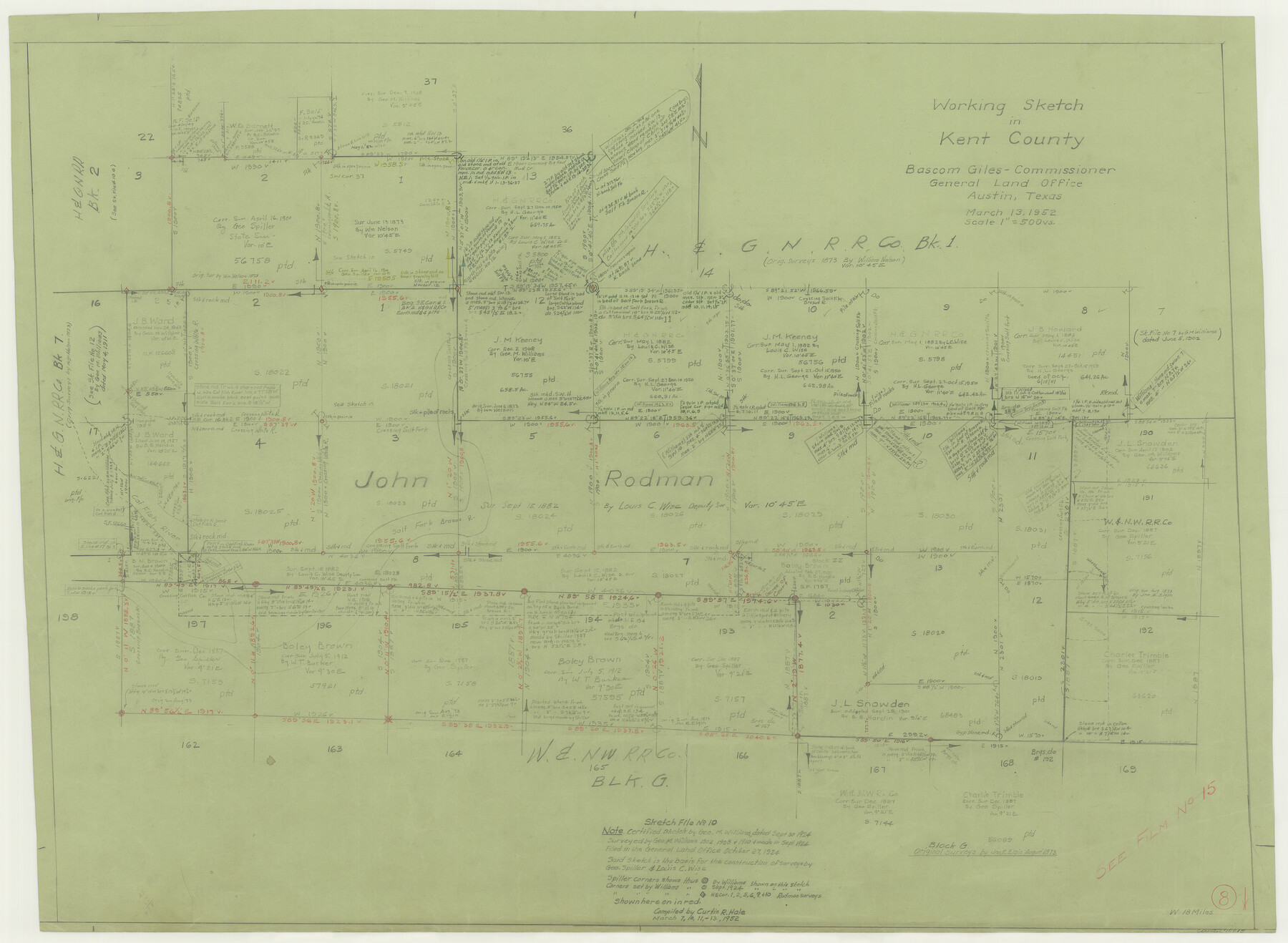
Kent County Working Sketch 8
-
Map/Doc
70015
-
Collection
General Map Collection
-
Object Dates
3/13/1952 (Creation Date)
-
People and Organizations
Curtis R. Hale (Compiler)
-
Counties
Kent
-
Subjects
Surveying Working Sketch
-
Height x Width
27.2 x 37.1 inches
69.1 x 94.2 cm
-
Scale
1" = 500 varas
Part of: General Map Collection
Reeves County Rolled Sketch 24

Print $20.00
- Digital $50.00
Reeves County Rolled Sketch 24
1982
Size 37.2 x 24.9 inches
Map/Doc 7493
Gray County Boundary File 4

Print $34.00
- Digital $50.00
Gray County Boundary File 4
Size 11.4 x 8.9 inches
Map/Doc 53876
Tom Green County Sketch File 16

Print $16.00
- Digital $50.00
Tom Green County Sketch File 16
Size 8.5 x 7.8 inches
Map/Doc 38174
Pecos County Sketch File 29b

Print $12.00
- Digital $50.00
Pecos County Sketch File 29b
1929
Size 14.3 x 8.8 inches
Map/Doc 33692
Newton County Sketch File 48

Print $4.00
- Digital $50.00
Newton County Sketch File 48
Size 12.4 x 7.9 inches
Map/Doc 32460
Rusk County Working Sketch 18

Print $20.00
- Digital $50.00
Rusk County Working Sketch 18
1955
Size 32.6 x 28.3 inches
Map/Doc 63653
Van Zandt County Sketch File 18

Print $4.00
- Digital $50.00
Van Zandt County Sketch File 18
1858
Size 9.7 x 7.7 inches
Map/Doc 39420
Roberts County Working Sketch 2

Print $20.00
- Digital $50.00
Roberts County Working Sketch 2
1939
Size 10.8 x 17.7 inches
Map/Doc 63528
Throckmorton County Rolled Sketch 5

Print $20.00
- Digital $50.00
Throckmorton County Rolled Sketch 5
2001
Size 25.0 x 35.9 inches
Map/Doc 76405
Flight Mission No. DAG-14K, Frame 133, Matagorda County

Print $20.00
- Digital $50.00
Flight Mission No. DAG-14K, Frame 133, Matagorda County
1952
Size 17.6 x 17.4 inches
Map/Doc 86304
Lamar County Working Sketch 8

Print $20.00
- Digital $50.00
Lamar County Working Sketch 8
1969
Size 39.3 x 31.6 inches
Map/Doc 70269
Colorado County Working Sketch 7

Print $20.00
- Digital $50.00
Colorado County Working Sketch 7
1922
Size 23.8 x 23.2 inches
Map/Doc 68107
You may also like
Trinity River, Barnett Crossing Sheet/Brushy and Kings Creek

Print $20.00
- Digital $50.00
Trinity River, Barnett Crossing Sheet/Brushy and Kings Creek
1927
Size 41.3 x 30.2 inches
Map/Doc 65221
Brazoria County Sketch File 12a

Print $4.00
- Digital $50.00
Brazoria County Sketch File 12a
1886
Size 11.2 x 8.5 inches
Map/Doc 14971
Rio Grande from San Juan River to the Gulf of Mexico showing Boundary between the United States and Mexico

Print $20.00
- Digital $50.00
Rio Grande from San Juan River to the Gulf of Mexico showing Boundary between the United States and Mexico
1903
Size 25.6 x 15.8 inches
Map/Doc 2065
North Sulphur River, Mt. Joy Sheet

Print $20.00
- Digital $50.00
North Sulphur River, Mt. Joy Sheet
1926
Size 18.4 x 21.6 inches
Map/Doc 78333
Culberson County Working Sketch 40

Print $40.00
- Digital $50.00
Culberson County Working Sketch 40
1966
Size 35.5 x 60.9 inches
Map/Doc 68493
Brazos River, Sugarland Sheet

Print $20.00
- Digital $50.00
Brazos River, Sugarland Sheet
1938
Size 31.0 x 40.6 inches
Map/Doc 65288
Flight Mission No. DIX-5P, Frame 109, Aransas County

Print $20.00
- Digital $50.00
Flight Mission No. DIX-5P, Frame 109, Aransas County
1956
Size 17.8 x 18.1 inches
Map/Doc 83788
Lubbock County Working Sketch 7

Print $20.00
- Digital $50.00
Lubbock County Working Sketch 7
1964
Size 21.9 x 25.3 inches
Map/Doc 70667
Erath County Working Sketch 10

Print $20.00
- Digital $50.00
Erath County Working Sketch 10
1948
Size 28.7 x 24.5 inches
Map/Doc 69091
[Sketch for Mineral Application 24072, San Jacinto River]
![65594, [Sketch for Mineral Application 24072, San Jacinto River], General Map Collection](https://historictexasmaps.com/wmedia_w700/maps/65594.tif.jpg)
Print $20.00
- Digital $50.00
[Sketch for Mineral Application 24072, San Jacinto River]
1929
Size 25.8 x 20.8 inches
Map/Doc 65594
DeWitt County Sketch File 9

Print $22.00
- Digital $50.00
DeWitt County Sketch File 9
1878
Size 5.6 x 5.9 inches
Map/Doc 20820
Hudspeth County Working Sketch 52

Print $20.00
- Digital $50.00
Hudspeth County Working Sketch 52
1985
Size 29.8 x 36.6 inches
Map/Doc 66337