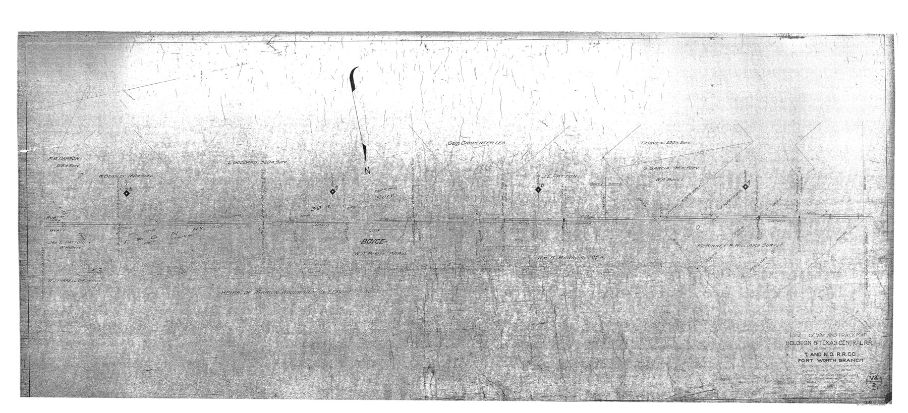
Right of Way and Track Map - Houston & Texas Central R.R. operated by the T. and N. O. R.R. Co. - Fort Worth Branch
Station 190+00 to Station 400+00
Z-2-221
-
Map/Doc
82861
-
Collection
General Map Collection
-
Object Dates
1930/12/31 (Revision Date)
1927/12/31 (Revision Date)
1918/6/30 (Creation Date)
-
People and Organizations
Office of Assistant General Manager (Publisher)
Wayne C. Terry, RPLS (Donor)
-
Counties
Ellis
-
Subjects
Railroads
-
Height x Width
26.5 x 58.3 inches
67.3 x 148.1 cm
-
Medium
paper, photocopy
-
Scale
1" = 400'
-
Comments
Donated to the Texas General Land Office by Wayne C. Terry, RPLS, October 11, 2004.
-
Features
H&TC
T&NO
Boyce
Part of: General Map Collection
Real County Working Sketch 75

Print $20.00
- Digital $50.00
Real County Working Sketch 75
1979
Size 29.0 x 28.6 inches
Map/Doc 71967
Asher and Adams' Texas

Print $20.00
- Digital $50.00
Asher and Adams' Texas
1871
Size 25.4 x 18.5 inches
Map/Doc 93788
Eastland County Working Sketch 48

Print $20.00
- Digital $50.00
Eastland County Working Sketch 48
1981
Size 35.1 x 25.5 inches
Map/Doc 68829
No. 2 Chart of Corpus Christi Pass, Texas

Print $20.00
- Digital $50.00
No. 2 Chart of Corpus Christi Pass, Texas
1878
Size 18.3 x 27.4 inches
Map/Doc 73022
Hudspeth County Sketch File 21

Print $40.00
- Digital $50.00
Hudspeth County Sketch File 21
Size 60.1 x 38.0 inches
Map/Doc 10495
Location of the Southern Kansas Railway of Texas, Carson County, Texas

Print $40.00
- Digital $50.00
Location of the Southern Kansas Railway of Texas, Carson County, Texas
1887
Size 20.5 x 84.3 inches
Map/Doc 64035
Kaufman County Sketch File 10a

Print $20.00
- Digital $50.00
Kaufman County Sketch File 10a
1871
Size 18.3 x 14.6 inches
Map/Doc 11906
Cass County Rolled Sketch WDC

Print $20.00
- Digital $50.00
Cass County Rolled Sketch WDC
Size 20.8 x 32.9 inches
Map/Doc 5416
San Patricio County Rolled Sketch 43

Print $1233.00
- Digital $50.00
San Patricio County Rolled Sketch 43
Size 8.8 x 14.2 inches
Map/Doc 41814

Edwards County Boundary File 27

Print $8.00
- Digital $50.00
Edwards County Boundary File 27
Size 8.8 x 3.9 inches
Map/Doc 52876
Ward County Working Sketch 1

Print $20.00
- Digital $50.00
Ward County Working Sketch 1
1937
Size 24.7 x 24.5 inches
Map/Doc 72307
You may also like
Map of McCulloch County

Print $20.00
- Digital $50.00
Map of McCulloch County
1874
Size 26.7 x 20.7 inches
Map/Doc 3857

Montgomery County Working Sketch 75

Print $40.00
- Digital $50.00
Montgomery County Working Sketch 75
1986
Size 30.9 x 82.8 inches
Map/Doc 71182
Atascosa County Sketch File 13

Print $4.00
- Digital $50.00
Atascosa County Sketch File 13
1867
Size 12.8 x 8.2 inches
Map/Doc 13771
Mitchell County

Print $20.00
- Digital $50.00
Mitchell County
1889
Size 44.3 x 37.8 inches
Map/Doc 66935
[Map of Coahuila and Nuevo Leon]
![97128, [Map of Coahuila and Nuevo Leon], General Map Collection](https://historictexasmaps.com/wmedia_w700/maps/97128.tif.jpg)
Print $20.00
- Digital $50.00
[Map of Coahuila and Nuevo Leon]
1873
Size 16.8 x 11.6 inches
Map/Doc 97128
Martin County Sketch File 6

Print $4.00
- Digital $50.00
Martin County Sketch File 6
1914
Size 7.3 x 8.9 inches
Map/Doc 30642
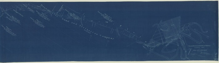
St. Louis, Brownsville & Mexico Railway Location Map from Mile 120 to Rio Grande
Print $40.00
- Digital $50.00
St. Louis, Brownsville & Mexico Railway Location Map from Mile 120 to Rio Grande
1905
Size 19.6 x 67.7 inches
Map/Doc 64170
[Texas & Pacific RR. Co. Blocks 6 and 4, L. C. Denison, Guadalupe College and vicinity]
![92133, [Texas & Pacific RR. Co. Blocks 6 and 4, L. C. Denison, Guadalupe College and vicinity], Twichell Survey Records](https://historictexasmaps.com/wmedia_w700/maps/92133-1.tif.jpg)
Print $20.00
- Digital $50.00
[Texas & Pacific RR. Co. Blocks 6 and 4, L. C. Denison, Guadalupe College and vicinity]
Size 32.5 x 19.8 inches
Map/Doc 92133
Map of Gray County

Print $20.00
- Digital $50.00
Map of Gray County
1900
Size 43.4 x 40.5 inches
Map/Doc 95511
Bowie County Sketch File 6a

Print $8.00
- Digital $50.00
Bowie County Sketch File 6a
1927
Size 10.6 x 8.6 inches
Map/Doc 14844
Travis County Sketch File 43

Print $30.00
- Digital $50.00
Travis County Sketch File 43
1887
Size 8.8 x 9.3 inches
Map/Doc 38359