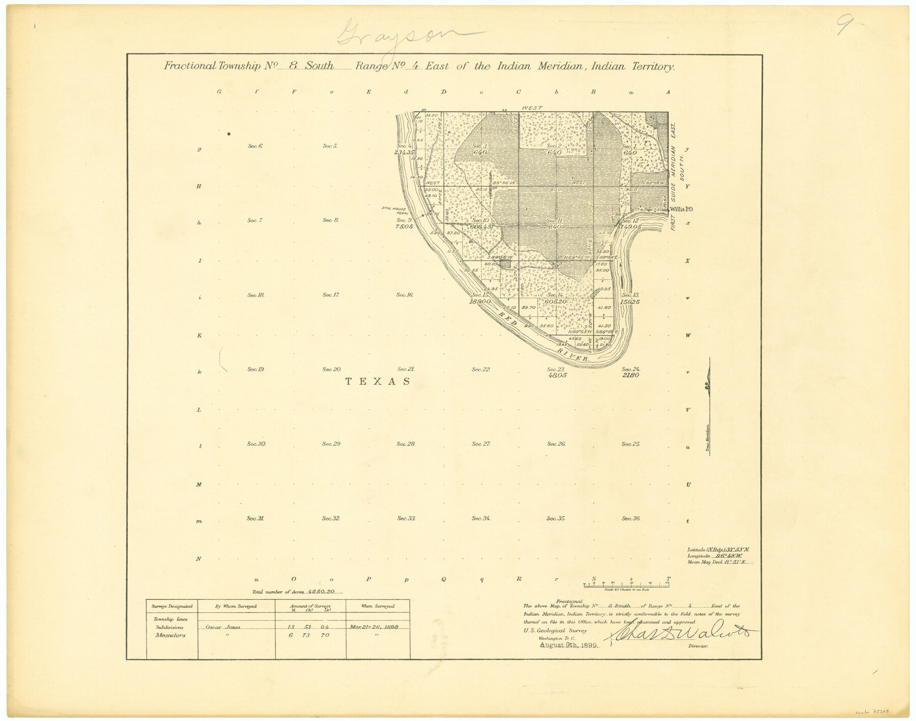
Fractional Township No. 8 South Range No. 4 East of the Indian Meridian, Indian Territory
-
Map/Doc
75208
-
Collection
General Map Collection
-
Object Dates
1898/3/26 (Creation Date)
-
Subjects
Texas Boundaries
-
Height x Width
19.2 x 24.4 inches
48.8 x 62.0 cm
Part of: General Map Collection
Flight Mission No. CRC-3R, Frame 44, Chambers County

Print $20.00
- Digital $50.00
Flight Mission No. CRC-3R, Frame 44, Chambers County
1956
Size 18.6 x 22.3 inches
Map/Doc 84817
Angelina County Working Sketch 2

Print $20.00
- Digital $50.00
Angelina County Working Sketch 2
1899
Size 18.3 x 23.4 inches
Map/Doc 67082
Flight Mission No. BRE-1P, Frame 72, Nueces County

Print $20.00
- Digital $50.00
Flight Mission No. BRE-1P, Frame 72, Nueces County
1956
Size 18.4 x 22.3 inches
Map/Doc 86654
Red River County Working Sketch 74

Print $20.00
- Digital $50.00
Red River County Working Sketch 74
1980
Size 24.2 x 22.8 inches
Map/Doc 72057
Die Eisenbahm von dem Missisippi nach dem stillen Ocean (Californien)

Print $20.00
- Digital $50.00
Die Eisenbahm von dem Missisippi nach dem stillen Ocean (Californien)
1856
Size 14.0 x 14.8 inches
Map/Doc 94075
Lipscomb County Rolled Sketch 6

Print $20.00
- Digital $50.00
Lipscomb County Rolled Sketch 6
1941
Size 45.0 x 46.0 inches
Map/Doc 9452
Wise County Sketch File 20

Print $14.00
- Digital $50.00
Wise County Sketch File 20
1860
Size 12.8 x 7.9 inches
Map/Doc 40557

Zapata County Rolled Sketch 10

Print $20.00
- Digital $50.00
Zapata County Rolled Sketch 10
1912
Size 25.4 x 26.6 inches
Map/Doc 8311
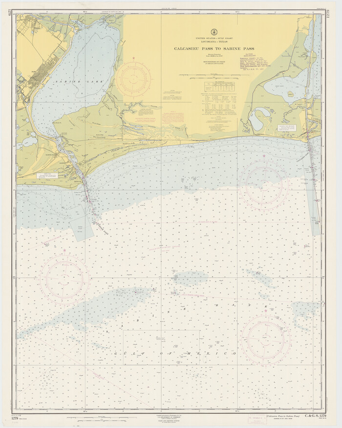
Calcasieu Pass to Sabine Pass
Print $20.00
- Digital $50.00
Calcasieu Pass to Sabine Pass
1961
Size 44.6 x 35.7 inches
Map/Doc 69809
Flight Mission No. DIX-3P, Frame 167, Aransas County

Print $20.00
- Digital $50.00
Flight Mission No. DIX-3P, Frame 167, Aransas County
1956
Size 17.8 x 18.0 inches
Map/Doc 83773
Hays County State Real Property Sketch 2

Print $20.00
- Digital $50.00
Hays County State Real Property Sketch 2
2006
Size 24.3 x 34.4 inches
Map/Doc 88619
You may also like
Jefferson County Sketch File 52

Print $2.00
- Digital $50.00
Jefferson County Sketch File 52
1985
Size 9.1 x 14.4 inches
Map/Doc 28254
Dickens County Sketch File H

Print $28.00
- Digital $50.00
Dickens County Sketch File H
Size 13.2 x 8.9 inches
Map/Doc 20861
Oldham County Sketch File 6

Print $20.00
- Digital $50.00
Oldham County Sketch File 6
1883
Size 31.4 x 42.8 inches
Map/Doc 10561
Flight Mission No. DCL-7C, Frame 17, Kenedy County

Print $20.00
- Digital $50.00
Flight Mission No. DCL-7C, Frame 17, Kenedy County
1943
Size 15.3 x 15.2 inches
Map/Doc 86009
Washington County

Print $20.00
- Digital $50.00
Washington County
1871
Size 11.9 x 27.7 inches
Map/Doc 4123
Presidio County Sketch File 52

Print $10.00
- Digital $50.00
Presidio County Sketch File 52
1921
Size 11.5 x 8.8 inches
Map/Doc 34605
Plat Proposed Location of Highway From Plains to Intersect Lovington Highway on New Mexico State Line

Print $20.00
- Digital $50.00
Plat Proposed Location of Highway From Plains to Intersect Lovington Highway on New Mexico State Line
Size 44.2 x 17.3 inches
Map/Doc 92856
Smith County Sketch File 14

Print $4.00
- Digital $50.00
Smith County Sketch File 14
1888
Size 12.3 x 8.8 inches
Map/Doc 36775
[Section 70, Block 8, Dawson and Lynn Counties, Texas]
![92562, [Section 70, Block 8, Dawson and Lynn Counties, Texas], Twichell Survey Records](https://historictexasmaps.com/wmedia_w700/maps/92562-1.tif.jpg)
Print $20.00
- Digital $50.00
[Section 70, Block 8, Dawson and Lynn Counties, Texas]
Size 23.9 x 19.6 inches
Map/Doc 92562
[Blocks WJG2, FR, 330]
![92330, [Blocks WJG2, FR, 330], Twichell Survey Records](https://historictexasmaps.com/wmedia_w700/maps/92330-1.tif.jpg)
Print $20.00
- Digital $50.00
[Blocks WJG2, FR, 330]
Size 25.8 x 25.8 inches
Map/Doc 92330
[Surveys Surrounding I. G. Yates S.F. 12394]
![91560, [Surveys Surrounding I. G. Yates S.F. 12394], Twichell Survey Records](https://historictexasmaps.com/wmedia_w700/maps/91560-1.tif.jpg)
Print $20.00
- Digital $50.00
[Surveys Surrounding I. G. Yates S.F. 12394]
Size 18.6 x 7.4 inches
Map/Doc 91560
Chambers County Working Sketch 5

Print $20.00
- Digital $50.00
Chambers County Working Sketch 5
1938
Size 20.9 x 31.6 inches
Map/Doc 67988