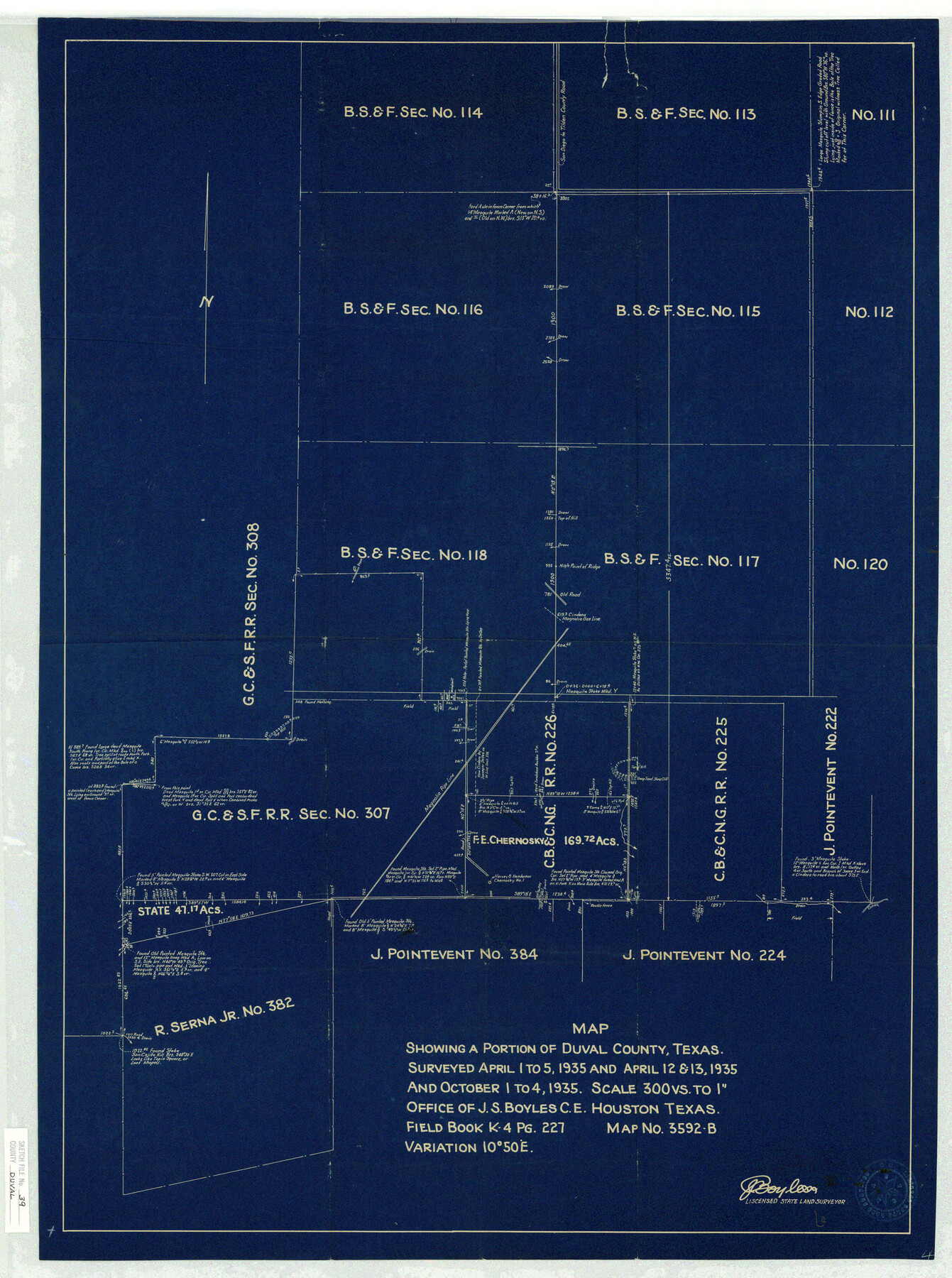
Duval County Sketch File 39
N. central part
-
Map/Doc
11395
-
Collection
General Map Collection
-
Object Dates
1935/10/18 (File Date)
1935 (Survey Date)
1935/10/4 (Survey Date)
-
People and Organizations
J.S. Boyles (Surveyor/Engineer)
-
Counties
Duval McMullen
-
Subjects
Surveying Sketch File
-
Height x Width
32.1 x 23.9 inches
81.5 x 60.7 cm
-
Medium
blueprint/diazo
-
Scale
1:300
Part of: General Map Collection
Map of Zapata County

Print $20.00
- Digital $50.00
Map of Zapata County
1879
Size 27.4 x 25.6 inches
Map/Doc 4176
Parker County Sketch File 48

Print $20.00
- Digital $50.00
Parker County Sketch File 48
1858
Size 17.6 x 22.3 inches
Map/Doc 12152
Dallam County Working Sketch Graphic Index

Print $40.00
- Digital $50.00
Dallam County Working Sketch Graphic Index
1926
Size 41.3 x 50.9 inches
Map/Doc 76516
Wood County Working Sketch 23

Print $40.00
- Digital $50.00
Wood County Working Sketch 23
1962
Size 54.9 x 43.5 inches
Map/Doc 78230
Jackson County Sketch File 31

Print $18.00
- Digital $50.00
Jackson County Sketch File 31
1940
Size 14.4 x 8.4 inches
Map/Doc 27756
Map of Panola County

Print $20.00
- Digital $50.00
Map of Panola County
1882
Size 20.9 x 22.0 inches
Map/Doc 4504
Grayson County Working Sketch 27

Print $20.00
- Digital $50.00
Grayson County Working Sketch 27
1988
Size 29.8 x 35.9 inches
Map/Doc 63266
McCulloch County Working Sketch Graphic Index

Print $20.00
- Digital $50.00
McCulloch County Working Sketch Graphic Index
1949
Size 47.3 x 37.4 inches
Map/Doc 76636
Pecos County Working Sketch 130

Print $20.00
- Digital $50.00
Pecos County Working Sketch 130
1976
Size 27.6 x 36.5 inches
Map/Doc 71604
Intracoastal Waterway in Texas - Corpus Christi to Point Isabel including Arroyo Colorado to Mo. Pac. R.R. Bridge Near Harlingen

Print $20.00
- Digital $50.00
Intracoastal Waterway in Texas - Corpus Christi to Point Isabel including Arroyo Colorado to Mo. Pac. R.R. Bridge Near Harlingen
1933
Size 40.6 x 28.0 inches
Map/Doc 61877

Map of Atascosa County, Texas

Print $20.00
- Digital $50.00
Map of Atascosa County, Texas
1916
Size 30.0 x 28.6 inches
Map/Doc 9006
You may also like
Houston & Great Northern R.R. from Troupe in Smith Co. the point of junction with International R.R. to Mineola in Wood Co. the point of junction with T. & P. R.R.

Print $22.00
- Digital $50.00
Houston & Great Northern R.R. from Troupe in Smith Co. the point of junction with International R.R. to Mineola in Wood Co. the point of junction with T. & P. R.R.
1873
Size 21.2 x 8.6 inches
Map/Doc 64301
Eastland County Working Sketch 45

Print $20.00
- Digital $50.00
Eastland County Working Sketch 45
1979
Size 31.3 x 43.7 inches
Map/Doc 68826
Zavala County Sketch File 48

Print $6.00
- Digital $50.00
Zavala County Sketch File 48
1942
Size 11.4 x 9.0 inches
Map/Doc 41438
Bee County Sketch File 8a

Print $8.00
- Digital $50.00
Bee County Sketch File 8a
1874
Size 6.0 x 7.6 inches
Map/Doc 14283
C. B. Livestock Co.'s West-Ranch, Bailey County, Texas

Print $2.00
- Digital $50.00
C. B. Livestock Co.'s West-Ranch, Bailey County, Texas
Size 11.2 x 8.9 inches
Map/Doc 90381
Val Verde County Working Sketch 7

Print $20.00
- Digital $50.00
Val Verde County Working Sketch 7
1915
Size 21.9 x 19.5 inches
Map/Doc 72142
Map of Shelby County

Print $20.00
- Digital $50.00
Map of Shelby County
1863
Size 18.6 x 22.3 inches
Map/Doc 4031
Knox County Rolled Sketch 15

Print $40.00
- Digital $50.00
Knox County Rolled Sketch 15
1892
Size 21.9 x 54.8 inches
Map/Doc 10667
McCulloch County Rolled Sketch 6

Print $20.00
- Digital $50.00
McCulloch County Rolled Sketch 6
1982
Size 27.9 x 33.9 inches
Map/Doc 6717
Houston Ship Channel, Atkinson Island to Alexander Island

Print $40.00
- Digital $50.00
Houston Ship Channel, Atkinson Island to Alexander Island
1975
Size 36.2 x 50.4 inches
Map/Doc 69903
Haskell County Working Sketch 15

Print $40.00
- Digital $50.00
Haskell County Working Sketch 15
1983
Size 48.0 x 57.5 inches
Map/Doc 66073
Sketch of Menard Co.

Print $20.00
- Digital $50.00
Sketch of Menard Co.
1883
Size 15.1 x 14.2 inches
Map/Doc 536