Current Miscellaneous File 28
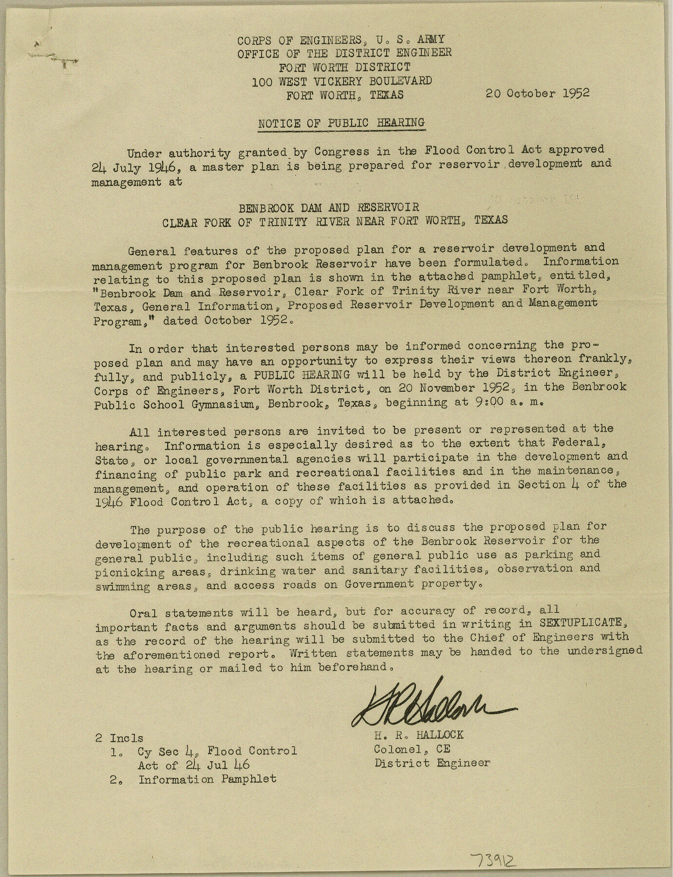
Notice of Public Hearing - Corps of Engineers, Ft. Worth, Texas, Benbrook Dam and Reservoir, Clear Fork of Trinity River near Ft. Worth
-
Map/Doc
73911
-
Collection
General Map Collection
-
Object Dates
1952/10/20 (Creation Date)
-
Subjects
Curiosities
-
Height x Width
10.7 x 16.3 inches
27.2 x 41.4 cm
Part of: General Map Collection
Culberson County Working Sketch 2

Print $20.00
- Digital $50.00
Culberson County Working Sketch 2
Size 27.7 x 18.7 inches
Map/Doc 68454
Bell County Rolled Sketch 1

Print $20.00
- Digital $50.00
Bell County Rolled Sketch 1
1954
Size 38.1 x 41.1 inches
Map/Doc 75938
Harris County Historic Topographic 23

Print $20.00
- Digital $50.00
Harris County Historic Topographic 23
1916
Size 29.2 x 22.6 inches
Map/Doc 65834
Foard County Rolled Sketch 11

Print $20.00
- Digital $50.00
Foard County Rolled Sketch 11
Size 29.2 x 35.6 inches
Map/Doc 5885
Anderson County Rolled Sketch 11

Print $20.00
- Digital $50.00
Anderson County Rolled Sketch 11
1956
Size 33.4 x 34.4 inches
Map/Doc 8366
Van Zandt County Sketch File 18

Print $4.00
- Digital $50.00
Van Zandt County Sketch File 18
1858
Size 9.7 x 7.7 inches
Map/Doc 39420
Winkler County Sketch File 17

Print $18.00
- Digital $50.00
Winkler County Sketch File 17
1920
Size 14.3 x 8.6 inches
Map/Doc 40508
Comanche County Sketch File 4

Print $40.00
- Digital $50.00
Comanche County Sketch File 4
1855
Size 19.0 x 15.9 inches
Map/Doc 19057
Map of Milam County

Print $20.00
- Digital $50.00
Map of Milam County
1868
Size 28.2 x 23.9 inches
Map/Doc 3882
Map and Street Guide of Austin, Texas and Urban Areas

Map and Street Guide of Austin, Texas and Urban Areas
1972
Size 48.6 x 33.9 inches
Map/Doc 82029
Taylor County Rolled Sketch 26

Print $20.00
- Digital $50.00
Taylor County Rolled Sketch 26
1982
Size 35.0 x 35.0 inches
Map/Doc 9987
United States - Gulf Coast - From Latitude 26° 33' to the Rio Grande Texas

Print $20.00
- Digital $50.00
United States - Gulf Coast - From Latitude 26° 33' to the Rio Grande Texas
1916
Size 27.9 x 18.3 inches
Map/Doc 72838
You may also like
King County Working Sketch 4

Print $20.00
- Digital $50.00
King County Working Sketch 4
1939
Size 42.9 x 25.7 inches
Map/Doc 70168
[Sketch showing county line between Randall and Potter Counties]
![91760, [Sketch showing county line between Randall and Potter Counties], Twichell Survey Records](https://historictexasmaps.com/wmedia_w700/maps/91760-1.tif.jpg)
Print $20.00
- Digital $50.00
[Sketch showing county line between Randall and Potter Counties]
Size 18.8 x 37.0 inches
Map/Doc 91760
Map of the CB Live Stock Co. -N- Ranch situated in Crosby County, Texas

Print $20.00
- Digital $50.00
Map of the CB Live Stock Co. -N- Ranch situated in Crosby County, Texas
Size 21.2 x 38.1 inches
Map/Doc 90332
Jeff Davis County Rolled Sketch 44

Print $20.00
- Digital $50.00
Jeff Davis County Rolled Sketch 44
2014
Size 19.8 x 34.7 inches
Map/Doc 94243
Flight Mission No. CRC-1R, Frame 34, Chambers County

Print $20.00
- Digital $50.00
Flight Mission No. CRC-1R, Frame 34, Chambers County
1956
Size 18.8 x 22.4 inches
Map/Doc 84702
Jefferson County Sketch File 22

Print $22.00
- Digital $50.00
Jefferson County Sketch File 22
Size 7.6 x 11.9 inches
Map/Doc 28179
Republic of Texas and Boundaries as Claimed by Texas from Decr. 19th, 1836 to Novr. 25th, 1850

Print $20.00
- Digital $50.00
Republic of Texas and Boundaries as Claimed by Texas from Decr. 19th, 1836 to Novr. 25th, 1850
Size 18.4 x 20.8 inches
Map/Doc 92063
Fair View Heights Addition to City of Lubbock Located on Survey 80, Blk. A

Print $20.00
- Digital $50.00
Fair View Heights Addition to City of Lubbock Located on Survey 80, Blk. A
Size 15.5 x 19.5 inches
Map/Doc 92770
Tyler County Sketch File 24

Print $16.00
- Digital $50.00
Tyler County Sketch File 24
1944
Size 11.2 x 9.0 inches
Map/Doc 38681
[North Part of Block G]
![92637, [North Part of Block G], Twichell Survey Records](https://historictexasmaps.com/wmedia_w700/maps/92637-1.tif.jpg)
Print $20.00
- Digital $50.00
[North Part of Block G]
Size 24.1 x 19.7 inches
Map/Doc 92637
Packery Channel

Print $20.00
- Digital $50.00
Packery Channel
1975
Size 26.2 x 21.5 inches
Map/Doc 2991
Edwards County Working Sketch 58

Print $20.00
- Digital $50.00
Edwards County Working Sketch 58
1953
Size 22.4 x 29.8 inches
Map/Doc 68934