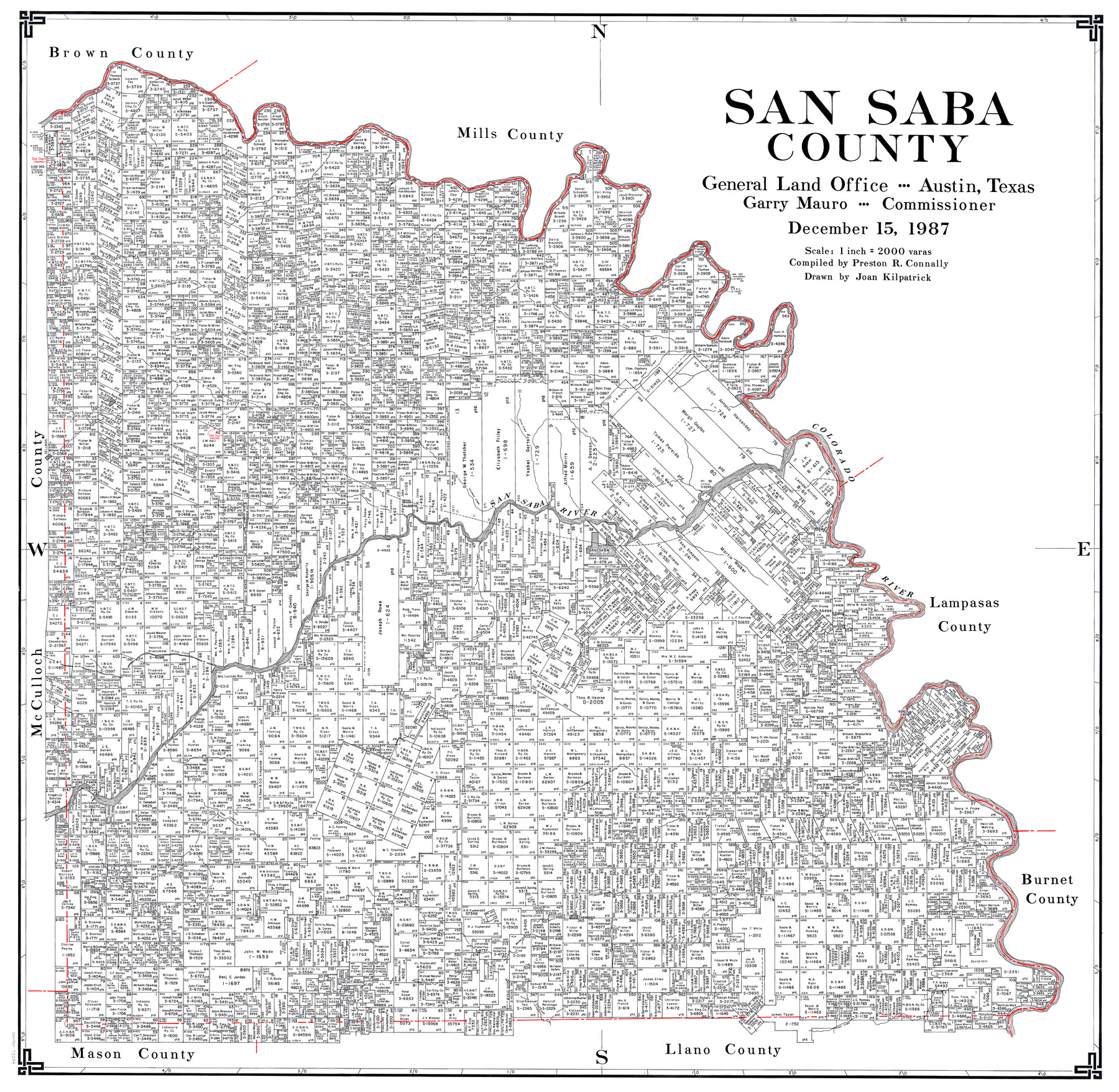
San Saba County
-
Map/Doc
73284
-
Collection
General Map Collection
-
Object Dates
12/15/1987 (Creation Date)
-
People and Organizations
Garry Mauro (GLO Commissioner)
Preston R. Connally (Compiler)
Joan Kilpatrick (Draftsman)
-
Counties
San Saba
-
Subjects
County
-
Height x Width
46.3 x 42.5 inches
117.6 x 108.0 cm
-
Scale
1" = 2000 varas
-
Comments
Leroy lettered.
-
Features
Cherokee
Terry Creek
Wallace Creek
Brady Creek
Bend
Chappell
Marble Creek
Deep Creek
Spicewood Creek
Mineral Creek
Hershey
Cold Creek
Cherokee Creek
Llano Creek
Fall Creek
Pecan Creek
Sellman
GC&SF
Deer Creek
Richland Springs
Mountain Creek
Wilbarger Creek
Lake View
North Fork of Horse Creek
Hall
Bowser
Holt
Locker
Horse Creek
Elm Creek
China Creek
Camp Creek
Colorado River
San Saba River
Richland Creek
Algerita
Jobes Creek
San Saba
Part of: General Map Collection
Port of Galveston

Print $40.00
- Digital $50.00
Port of Galveston
1978
Size 20.0 x 68.9 inches
Map/Doc 83336
Schleicher County Working Sketch 21

Print $20.00
- Digital $50.00
Schleicher County Working Sketch 21
1953
Size 26.6 x 10.8 inches
Map/Doc 63823
Montgomery County Rolled Sketch 19A

Print $40.00
- Digital $50.00
Montgomery County Rolled Sketch 19A
1933
Size 52.9 x 37.3 inches
Map/Doc 8349
Somervell County Sketch File 6

Print $6.00
- Digital $50.00
Somervell County Sketch File 6
1939
Size 13.6 x 8.6 inches
Map/Doc 36847
Hale County Sketch File D

Print $40.00
- Digital $50.00
Hale County Sketch File D
1901
Size 16.5 x 12.2 inches
Map/Doc 24721
Flight Mission No. DIX-6P, Frame 115, Aransas County

Print $20.00
- Digital $50.00
Flight Mission No. DIX-6P, Frame 115, Aransas County
1956
Size 19.3 x 22.8 inches
Map/Doc 83821
Township No. 2 South Range No. 23 West of the Indian Meridian

Print $20.00
- Digital $50.00
Township No. 2 South Range No. 23 West of the Indian Meridian
1875
Size 19.3 x 24.4 inches
Map/Doc 75175
Flight Mission No. BRA-17M, Frame 9, Jefferson County

Print $20.00
- Digital $50.00
Flight Mission No. BRA-17M, Frame 9, Jefferson County
1953
Size 18.6 x 22.2 inches
Map/Doc 85790
[Sketch for Mineral Applications 26885-6 - Reagan and Crockett Cos., W. H. Bland]
![65671, [Sketch for Mineral Applications 26885-6 - Reagan and Crockett Cos., W. H. Bland], General Map Collection](https://historictexasmaps.com/wmedia_w700/maps/65671-1.tif.jpg)
Print $40.00
- Digital $50.00
[Sketch for Mineral Applications 26885-6 - Reagan and Crockett Cos., W. H. Bland]
Size 37.3 x 51.0 inches
Map/Doc 65671
Pecos County Rolled Sketch 115

Print $20.00
- Digital $50.00
Pecos County Rolled Sketch 115
1943
Size 24.0 x 21.6 inches
Map/Doc 7257
Aransas County Sketch File 21d

Print $4.00
- Digital $50.00
Aransas County Sketch File 21d
Size 14.4 x 8.9 inches
Map/Doc 13164
Map of Callahan County

Print $20.00
- Digital $50.00
Map of Callahan County
1878
Size 23.0 x 18.8 inches
Map/Doc 3361
You may also like
Liberty County Sketch File X

Print $20.00
- Digital $50.00
Liberty County Sketch File X
Size 39.0 x 24.9 inches
Map/Doc 76769
Culberson County Rolled Sketch 67

Print $20.00
- Digital $50.00
Culberson County Rolled Sketch 67
1969
Size 18.1 x 23.1 inches
Map/Doc 5785
Grimes County Rolled Sketch 2

Print $20.00
- Digital $50.00
Grimes County Rolled Sketch 2
Size 29.2 x 24.3 inches
Map/Doc 6043
Duval County Sketch File 42

Print $4.00
- Digital $50.00
Duval County Sketch File 42
1936
Size 14.4 x 8.8 inches
Map/Doc 21394
Controlled Mosaic by Jack Amman Photogrammetric Engineers, Inc - Sheet 53

Print $20.00
- Digital $50.00
Controlled Mosaic by Jack Amman Photogrammetric Engineers, Inc - Sheet 53
1954
Size 20.0 x 24.0 inches
Map/Doc 83512
Hopkins County Sketch File 7

Print $6.00
- Digital $50.00
Hopkins County Sketch File 7
Size 10.4 x 6.1 inches
Map/Doc 26692
McMullen County Working Sketch 10

Print $20.00
- Digital $50.00
McMullen County Working Sketch 10
1938
Size 21.6 x 22.8 inches
Map/Doc 70711
Galveston County Rolled Sketch US

Print $20.00
- Digital $50.00
Galveston County Rolled Sketch US
1929
Size 27.6 x 44.6 inches
Map/Doc 9087
Jeff Davis County Sketch File 45

Print $10.00
- Digital $50.00
Jeff Davis County Sketch File 45
1890
Size 14.0 x 8.5 inches
Map/Doc 28075
Flight Mission No. BRE-3P, Frame 80, Nueces County

Print $20.00
- Digital $50.00
Flight Mission No. BRE-3P, Frame 80, Nueces County
1956
Size 18.7 x 22.6 inches
Map/Doc 86821
Hunt County Working Sketch 6

Print $20.00
- Digital $50.00
Hunt County Working Sketch 6
1942
Size 31.0 x 40.3 inches
Map/Doc 66353
Cooke County Working Sketch 31

Print $20.00
- Digital $50.00
Cooke County Working Sketch 31
1980
Size 27.0 x 32.2 inches
Map/Doc 68268