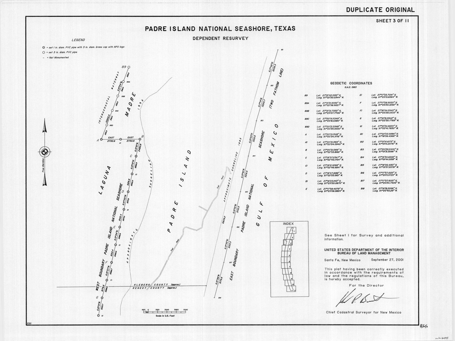
Padre Island National Seashore, Texas - Dependent Resurvey
-
Map/Doc
60545
-
Collection
General Map Collection
-
Object Dates
2001 (Creation Date)
-
Height x Width
18.3 x 24.4 inches
46.5 x 62.0 cm
Part of: General Map Collection
Brown County Sketch File 12a

Print $8.00
- Digital $50.00
Brown County Sketch File 12a
1870
Size 12.4 x 8.1 inches
Map/Doc 16604
Cooke County Sketch File 15

Print $4.00
- Digital $50.00
Cooke County Sketch File 15
1860
Size 12.5 x 8.1 inches
Map/Doc 19250
Martin County Working Sketch 3

Print $20.00
- Digital $50.00
Martin County Working Sketch 3
1950
Size 40.9 x 46.2 inches
Map/Doc 70821
Topographical Map of the Rio Grande, Sheet No. 15

Print $20.00
- Digital $50.00
Topographical Map of the Rio Grande, Sheet No. 15
1912
Map/Doc 89539
San Augustine County Working Sketch 26

Print $40.00
- Digital $50.00
San Augustine County Working Sketch 26
2008
Size 63.9 x 33.5 inches
Map/Doc 88823
Hardin County

Print $20.00
- Digital $50.00
Hardin County
1940
Size 47.4 x 42.4 inches
Map/Doc 73171
Packery Channel

Print $20.00
- Digital $50.00
Packery Channel
1971
Size 30.4 x 35.6 inches
Map/Doc 2993
[Neches River Bed, Plat and Calculations]
![77100, [Neches River Bed, Plat and Calculations], General Map Collection](https://historictexasmaps.com/wmedia_w700/maps/77100.tif.jpg)
Print $20.00
- Digital $50.00
[Neches River Bed, Plat and Calculations]
1928
Size 25.6 x 37.2 inches
Map/Doc 77100
Colorado County Working Sketch 25

Print $20.00
- Digital $50.00
Colorado County Working Sketch 25
1972
Size 39.1 x 34.2 inches
Map/Doc 68125
Photostat of section of hydrographic surveys H-5399, H-4822, H-470

Print $2.00
- Digital $50.00
Photostat of section of hydrographic surveys H-5399, H-4822, H-470
1933
Size 10.6 x 8.1 inches
Map/Doc 61159
Orange County Working Sketch 44

Print $20.00
- Digital $50.00
Orange County Working Sketch 44
1980
Size 16.5 x 22.0 inches
Map/Doc 71376

You may also like
Orange County Sketch File 41

Print $40.00
- Digital $50.00
Orange County Sketch File 41
1918
Size 13.2 x 13.3 inches
Map/Doc 33381
Travis County State Real Property Sketch 18

Print $20.00
Travis County State Real Property Sketch 18
2005
Size 24.4 x 35.2 inches
Map/Doc 96976
Harris County Sketch File 9

Print $4.00
- Digital $50.00
Harris County Sketch File 9
1861
Size 6.7 x 7.3 inches
Map/Doc 25340
Bandera County Rolled Sketch 7

Print $20.00
- Digital $50.00
Bandera County Rolled Sketch 7
Size 42.7 x 29.0 inches
Map/Doc 5118
Liberty County Sketch File 16

Print $4.00
- Digital $50.00
Liberty County Sketch File 16
1859
Size 11.4 x 6.7 inches
Map/Doc 29917
Land Grant Map of Comal County

Print $20.00
- Digital $50.00
Land Grant Map of Comal County
2006
Size 33.3 x 41.0 inches
Map/Doc 83601

Harris County Rolled Sketch 43

Print $20.00
- Digital $50.00
Harris County Rolled Sketch 43
1919
Size 15.3 x 18.9 inches
Map/Doc 6101
Lampasas County Boundary File 10

Print $11.00
- Digital $50.00
Lampasas County Boundary File 10
Size 12.8 x 7.9 inches
Map/Doc 56184
Collingsworth County Rolled Sketch 3

Print $40.00
- Digital $50.00
Collingsworth County Rolled Sketch 3
1941
Size 55.7 x 23.2 inches
Map/Doc 8639
Flight Mission No. BRE-2P, Frame 62, Nueces County

Print $20.00
- Digital $50.00
Flight Mission No. BRE-2P, Frame 62, Nueces County
1956
Size 18.3 x 22.5 inches
Map/Doc 86757
Burleson County Sketch File 9

Print $12.00
- Digital $50.00
Burleson County Sketch File 9
1929
Size 14.2 x 8.1 inches
Map/Doc 16657