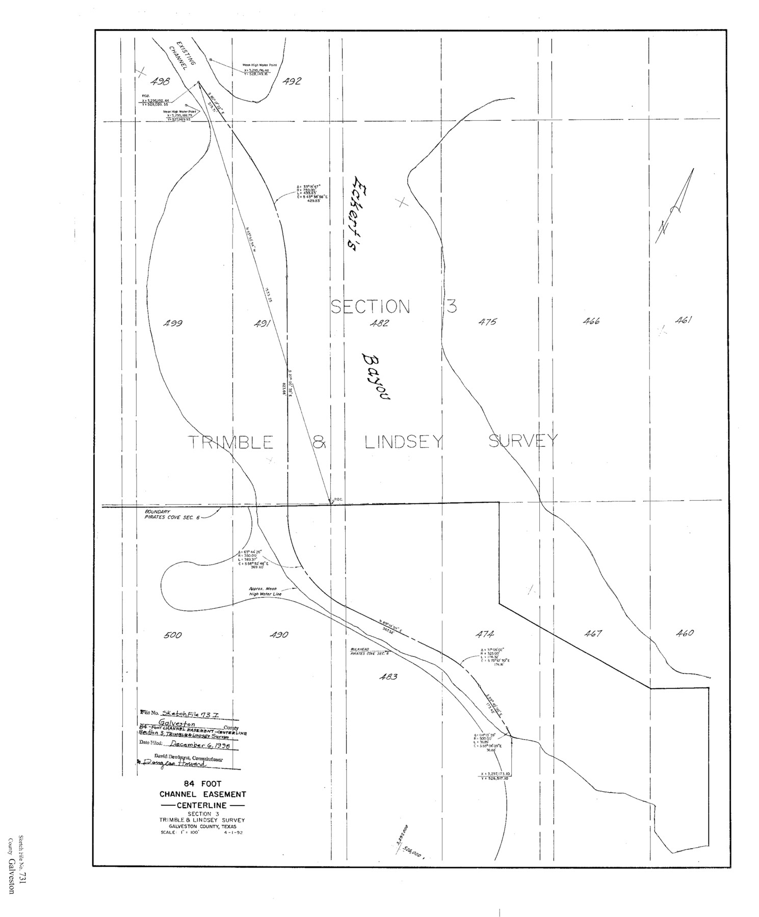
Galveston County Sketch File 73I
84 Foot Channel Easement Centerline Section 3, Trimble & Lindsey Survey
-
Map/Doc
11543
-
Collection
General Map Collection
-
Counties
Galveston
-
Subjects
Surveying Sketch File
-
Height x Width
31.5 x 26.0 inches
80.0 x 66.0 cm
-
Medium
paper, print
-
Scale
1" = 100 feet
-
Features
Eckert's Bayou
Existing Channel
Pirate's Cove Subdivision
Part of: General Map Collection
Coast Chart No. 210 Aransas Pass and Corpus Christi Bay with the coast to latitude 27° 12' Texas

Print $20.00
- Digital $50.00
Coast Chart No. 210 Aransas Pass and Corpus Christi Bay with the coast to latitude 27° 12' Texas
1913
Size 27.4 x 18.3 inches
Map/Doc 72797
Flight Mission No. BRA-16M, Frame 119, Jefferson County

Print $20.00
- Digital $50.00
Flight Mission No. BRA-16M, Frame 119, Jefferson County
1953
Size 18.6 x 22.5 inches
Map/Doc 85729
Stephens County Sketch File 28

Print $14.00
- Digital $50.00
Stephens County Sketch File 28
1996
Size 14.2 x 8.6 inches
Map/Doc 37104
Trinity County

Print $20.00
- Digital $50.00
Trinity County
1946
Size 40.5 x 40.7 inches
Map/Doc 77440
St. Louis, Brownsville & Mexico Railway Location Map from Mile 100 to Mile 120
Print $40.00
- Digital $50.00
St. Louis, Brownsville & Mexico Railway Location Map from Mile 100 to Mile 120
1905
Size 19.4 x 67.8 inches
Map/Doc 64168
Outer Continental Shelf Leasing Maps (Texas Offshore Operations)

Print $20.00
- Digital $50.00
Outer Continental Shelf Leasing Maps (Texas Offshore Operations)
Size 17.6 x 13.6 inches
Map/Doc 75850
Coryell County Rolled Sketch 2

Print $20.00
- Digital $50.00
Coryell County Rolled Sketch 2
1951
Size 15.7 x 19.1 inches
Map/Doc 5566
Erath County Sketch File 1

Print $4.00
- Digital $50.00
Erath County Sketch File 1
Size 3.9 x 8.1 inches
Map/Doc 22253
Taylor County Sketch File 1

Print $20.00
- Digital $50.00
Taylor County Sketch File 1
Size 33.3 x 40.8 inches
Map/Doc 10381

[Surveys in Austin's Colony along the San Antonio Road and the Navasota River]
![202, [Surveys in Austin's Colony along the San Antonio Road and the Navasota River], General Map Collection](https://historictexasmaps.com/wmedia_w700/maps/202.tif.jpg)
Print $20.00
- Digital $50.00
[Surveys in Austin's Colony along the San Antonio Road and the Navasota River]
1833
Size 16.1 x 34.7 inches
Map/Doc 202
Hudspeth County Working Sketch 14

Print $20.00
- Digital $50.00
Hudspeth County Working Sketch 14
1953
Size 24.2 x 41.2 inches
Map/Doc 66296
You may also like
Lavaca County Working Sketch 5

Print $20.00
- Digital $50.00
Lavaca County Working Sketch 5
1940
Size 21.3 x 35.2 inches
Map/Doc 70358
Map of the chief part of the Western States and part of Virginia engraved to illustrate Mitchell's school and family geography

Print $20.00
- Digital $50.00
Map of the chief part of the Western States and part of Virginia engraved to illustrate Mitchell's school and family geography
1839
Size 11.8 x 17.8 inches
Map/Doc 93499
Matagorda County Rolled Sketch PHL1

Print $20.00
- Digital $50.00
Matagorda County Rolled Sketch PHL1
Size 36.5 x 39.1 inches
Map/Doc 9477
Chambers County Sketch File 56

Print $7.00
- Digital $50.00
Chambers County Sketch File 56
Size 14.8 x 8.7 inches
Map/Doc 18099
Pecos County Sketch File 97

Print $6.00
- Digital $50.00
Pecos County Sketch File 97
1957
Size 11.4 x 17.2 inches
Map/Doc 34000
Flight Mission No. CRC-1R, Frame 34, Chambers County

Print $20.00
- Digital $50.00
Flight Mission No. CRC-1R, Frame 34, Chambers County
1956
Size 18.8 x 22.4 inches
Map/Doc 84702
Angelina County Sketch File 15c

Print $16.00
- Digital $50.00
Angelina County Sketch File 15c
1838
Size 12.2 x 8.0 inches
Map/Doc 12972
Harbor of Brazos Santiago, Texas

Print $20.00
- Digital $50.00
Harbor of Brazos Santiago, Texas
1887
Size 27.3 x 18.3 inches
Map/Doc 72992
Crockett County Rolled Sketch 29

Print $20.00
- Digital $50.00
Crockett County Rolled Sketch 29
1927
Size 22.0 x 36.9 inches
Map/Doc 5781
Pecos County Working Sketch 79

Print $20.00
- Digital $50.00
Pecos County Working Sketch 79
1960
Size 22.6 x 24.3 inches
Map/Doc 71551
[Sketch showing a stretch of T. & P. RR. Line between PSL Blocks B-15 and B-16]
![90902, [Sketch showing a stretch of T. & P. RR. Line between PSL Blocks B-15 and B-16], Twichell Survey Records](https://historictexasmaps.com/wmedia_w700/maps/90902-1.tif.jpg)
Print $20.00
- Digital $50.00
[Sketch showing a stretch of T. & P. RR. Line between PSL Blocks B-15 and B-16]
Size 37.9 x 25.5 inches
Map/Doc 90902
Map of Mason County, Texas

Print $20.00
- Digital $50.00
Map of Mason County, Texas
Size 26.0 x 19.2 inches
Map/Doc 404