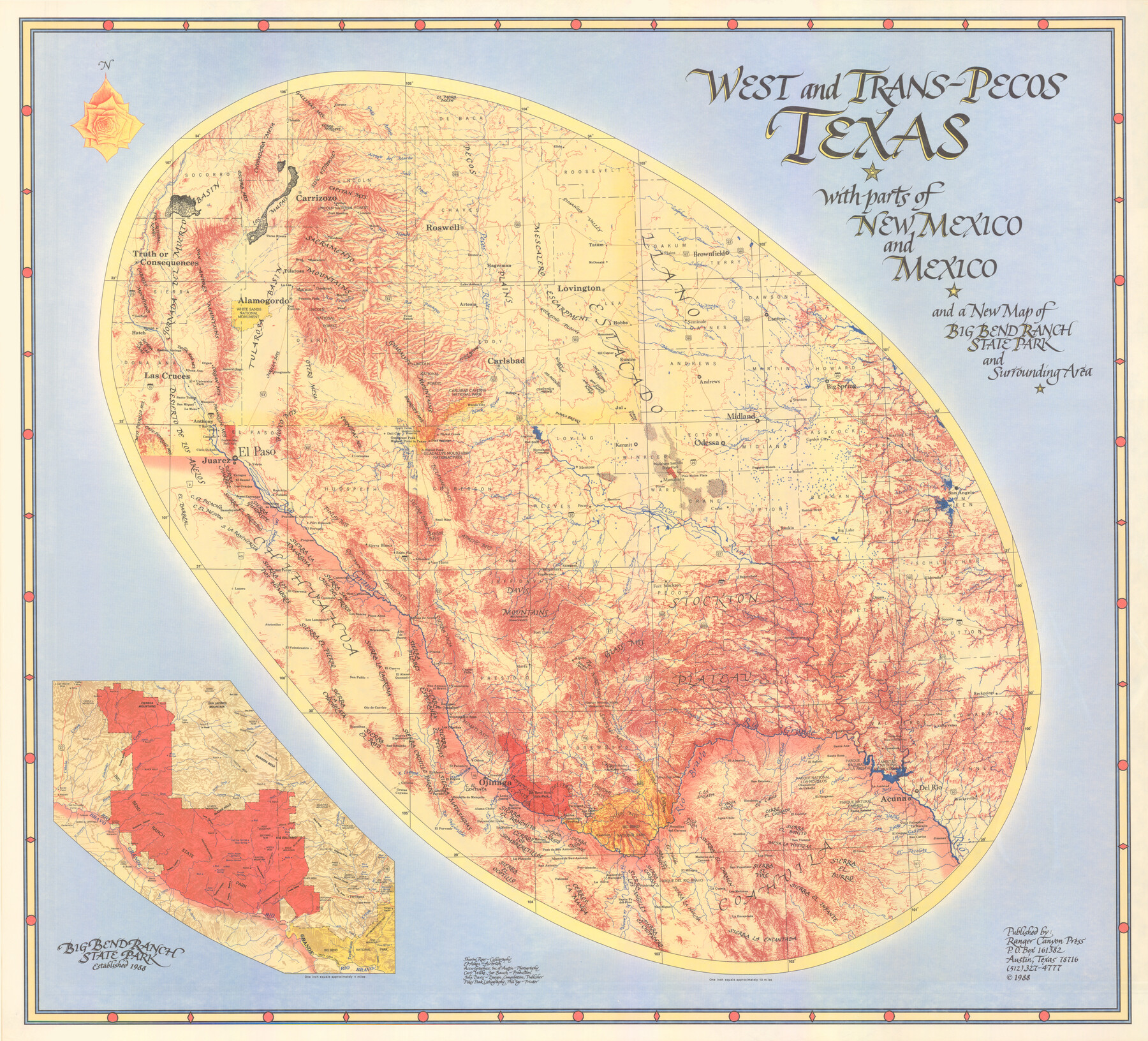
West and Trans-Pecos Texas with parts of New Mexico and Mexico and a New Map of Big Bend Ranch State Park and Surrounding Area
-
Map/Doc
89070
-
Collection
General Map Collection
-
Object Dates
1988 (Creation Date)
-
People and Organizations
Ranger Canyon Press (Publisher)
Pikes Peak Lithography (Printer)
John Davis (Draftsman)
Sharon L. Roos (Calligrapher)
Ed Aiken (Artist)
-
Subjects
Pictorial State of Texas
-
Height x Width
28.0 x 31.0 inches
71.1 x 78.7 cm
-
Medium
paper, etching/engraving/lithograph
-
Scale
1" = 13 miles / 1" = 4 miles (inset)
-
Comments
Features a Yellow Compass Rose. Calligraphy by Sharon Roos. Airbrushing by Ed Aiken.
-
URLs
https://medium.com/save-texas-history/my-favorite-map-west-and-trans-pecos-texas-with-parts-of-new-mexico-and-mexico-and-a-new-map-of-ce1f4518dfb5
Part of: General Map Collection
Refugio County NRC Article 33.136 Location Key Sheet

Print $20.00
- Digital $50.00
Refugio County NRC Article 33.136 Location Key Sheet
Size 26.3 x 22.3 inches
Map/Doc 87912
Polk County Working Sketch 33a

Print $20.00
- Digital $50.00
Polk County Working Sketch 33a
1960
Size 30.7 x 27.4 inches
Map/Doc 71649
Brazos Santiago, Texas

Print $20.00
- Digital $50.00
Brazos Santiago, Texas
1867
Size 25.6 x 18.2 inches
Map/Doc 72989
Map of the East Part of Tom Green County

Print $20.00
- Digital $50.00
Map of the East Part of Tom Green County
1894
Size 21.5 x 23.1 inches
Map/Doc 4083
Water Valley Sheet, North Concho River, Tom Green County

Print $20.00
- Digital $50.00
Water Valley Sheet, North Concho River, Tom Green County
1937
Size 23.6 x 19.1 inches
Map/Doc 65305
Comanche County Working Sketch 21

Print $20.00
- Digital $50.00
Comanche County Working Sketch 21
1973
Size 28.0 x 26.1 inches
Map/Doc 68155
Castro County Sketch File 4f

Print $4.00
- Digital $50.00
Castro County Sketch File 4f
Size 13.8 x 8.9 inches
Map/Doc 17475
Harris County Sketch File 102

Print $163.00
- Digital $50.00
Harris County Sketch File 102
1985
Size 11.4 x 8.9 inches
Map/Doc 25915
Menard County Rolled Sketch 13

Print $20.00
- Digital $50.00
Menard County Rolled Sketch 13
1972
Size 30.8 x 24.0 inches
Map/Doc 6759
Hutchinson County Sketch File 14

Print $20.00
- Digital $50.00
Hutchinson County Sketch File 14
1920
Size 21.5 x 33.8 inches
Map/Doc 11812

Duval County Boundary File 3c

Print $12.00
- Digital $50.00
Duval County Boundary File 3c
Size 11.7 x 8.4 inches
Map/Doc 52732
You may also like
Flight Mission No. BRA-16M, Frame 179, Jefferson County

Print $20.00
- Digital $50.00
Flight Mission No. BRA-16M, Frame 179, Jefferson County
1953
Size 18.7 x 22.2 inches
Map/Doc 85777
Pecos County Rolled Sketch 78

Print $40.00
- Digital $50.00
Pecos County Rolled Sketch 78
1930
Size 52.6 x 44.1 inches
Map/Doc 9705
[Map of the Houston and G. N. R.R. and lands adjacent, from Troupe to the Texas Pacific R.R.]
![64628, [Map of the Houston and G. N. R.R. and lands adjacent, from Troupe to the Texas Pacific R.R.], General Map Collection](https://historictexasmaps.com/wmedia_w700/maps/64628.tif.jpg)
Print $40.00
- Digital $50.00
[Map of the Houston and G. N. R.R. and lands adjacent, from Troupe to the Texas Pacific R.R.]
1873
Size 20.2 x 49.3 inches
Map/Doc 64628
Val Verde County Rolled Sketch 38

Print $20.00
- Digital $50.00
Val Verde County Rolled Sketch 38
Size 29.8 x 19.7 inches
Map/Doc 8114
Section 77, Block "A", Sylvan Sanders Survey

Print $20.00
- Digital $50.00
Section 77, Block "A", Sylvan Sanders Survey
1953
Size 24.7 x 16.0 inches
Map/Doc 92716
Gregg County Working Sketch 14

Print $20.00
- Digital $50.00
Gregg County Working Sketch 14
1941
Size 29.7 x 39.5 inches
Map/Doc 63281
Bastrop County Working Sketch Graphic Index

Print $40.00
- Digital $50.00
Bastrop County Working Sketch Graphic Index
1955
Size 49.6 x 40.9 inches
Map/Doc 76462
Travis County Working Sketch 29

Print $20.00
- Digital $50.00
Travis County Working Sketch 29
1960
Size 25.6 x 29.9 inches
Map/Doc 69413
Goliad County Sketch File 29

Print $2.00
- Digital $50.00
Goliad County Sketch File 29
Size 12.6 x 8.0 inches
Map/Doc 24326
Sutton County

Print $40.00
- Digital $50.00
Sutton County
1898
Size 41.1 x 58.3 inches
Map/Doc 78392
Carta Politica

Print $20.00
- Digital $50.00
Carta Politica
1897
Size 26.2 x 34.1 inches
Map/Doc 96797
Acts of the Visit of the Royal Commissioners (sometimes referred to as the “Visita General”) - Reynosa

Acts of the Visit of the Royal Commissioners (sometimes referred to as the “Visita General”) - Reynosa
1767
Size 14.1 x 9.3 inches
Map/Doc 94258