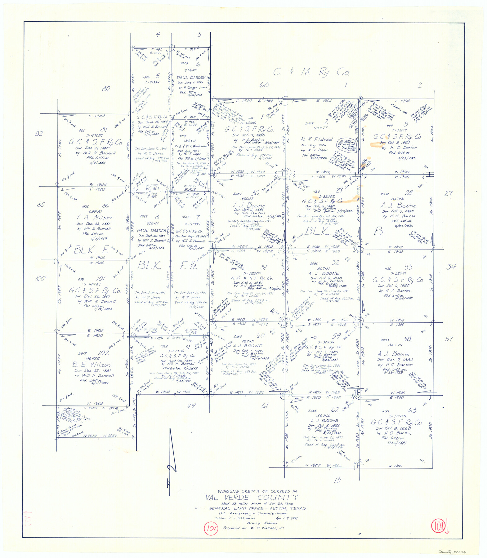
Val Verde County Working Sketch 101
-
Map/Doc
72236
-
Collection
General Map Collection
-
Object Dates
4/7/1981 (Creation Date)
-
People and Organizations
Beverly Robison (Draftsman)
-
Counties
Val Verde
-
Subjects
Surveying Working Sketch
-
Height x Width
29.1 x 25.4 inches
73.9 x 64.5 cm
-
Scale
1" = 500 varas
Part of: General Map Collection
Flight Mission No. DCL-6C, Frame 112, Kenedy County

Print $20.00
- Digital $50.00
Flight Mission No. DCL-6C, Frame 112, Kenedy County
1943
Size 15.4 x 15.5 inches
Map/Doc 85942
Map of Dallas County

Print $20.00
- Digital $50.00
Map of Dallas County
1861
Size 23.5 x 20.0 inches
Map/Doc 3467
Flight Mission No. CUG-3P, Frame 40, Kleberg County

Print $20.00
- Digital $50.00
Flight Mission No. CUG-3P, Frame 40, Kleberg County
1956
Size 18.5 x 22.2 inches
Map/Doc 86245
Harris County Sketch File 92

Print $20.00
- Digital $50.00
Harris County Sketch File 92
1932
Size 37.9 x 35.0 inches
Map/Doc 10483
Cochran County Boundary File 3

Print $160.00
- Digital $50.00
Cochran County Boundary File 3
Size 6.7 x 15.3 inches
Map/Doc 51476
La Salle County Sketch File 7

Print $22.00
- Digital $50.00
La Salle County Sketch File 7
Size 8.0 x 12.3 inches
Map/Doc 29456
Polk County Working Sketch 3

Print $40.00
- Digital $50.00
Polk County Working Sketch 3
1911
Size 25.4 x 56.0 inches
Map/Doc 71618
United States of America, compiled from the latest & best authorities by John Melish, 1820

Print $20.00
- Digital $50.00
United States of America, compiled from the latest & best authorities by John Melish, 1820
1820
Size 16.7 x 20.2 inches
Map/Doc 89220
Louisiana and Texas Intracoastal Waterway, Section 7, Galveston Bay to Brazos River and Section 8, Brazos River to Matagorda Bay

Print $20.00
- Digital $50.00
Louisiana and Texas Intracoastal Waterway, Section 7, Galveston Bay to Brazos River and Section 8, Brazos River to Matagorda Bay
1928
Size 31.3 x 42.7 inches
Map/Doc 73065
Amistad International Reservoir on Rio Grande 89a

Print $20.00
- Digital $50.00
Amistad International Reservoir on Rio Grande 89a
1949
Size 28.6 x 40.1 inches
Map/Doc 75518
Plat of the Resubdivision of the Abandoned Townsite of Eschiti, Oklahoma

Print $4.00
- Digital $50.00
Plat of the Resubdivision of the Abandoned Townsite of Eschiti, Oklahoma
1907
Size 18.1 x 24.3 inches
Map/Doc 75150
Flight Mission No. DCL-6C, Frame 131, Kenedy County

Print $20.00
- Digital $50.00
Flight Mission No. DCL-6C, Frame 131, Kenedy County
1943
Size 18.7 x 22.3 inches
Map/Doc 85961
You may also like
Duval County Working Sketch 43

Print $20.00
- Digital $50.00
Duval County Working Sketch 43
1977
Size 30.8 x 30.5 inches
Map/Doc 68767
Hall County Sketch File 9

Print $12.00
- Digital $50.00
Hall County Sketch File 9
Size 14.3 x 8.9 inches
Map/Doc 24802
Kimble County Sketch File 42

Print $10.00
- Digital $50.00
Kimble County Sketch File 42
1995
Size 11.2 x 8.8 inches
Map/Doc 29015
Jasper County Sketch File 8 and 9

Print $80.00
- Digital $50.00
Jasper County Sketch File 8 and 9
Size 8.2 x 6.9 inches
Map/Doc 27777

United States - Gulf Coast - Galveston to Rio Grande

Print $20.00
- Digital $50.00
United States - Gulf Coast - Galveston to Rio Grande
1919
Size 27.2 x 18.2 inches
Map/Doc 72750
Kansas and Nebraska

Print $20.00
- Digital $50.00
Kansas and Nebraska
Size 30.8 x 19.4 inches
Map/Doc 93994
Coke County Sketch File 16

Print $20.00
- Digital $50.00
Coke County Sketch File 16
1902
Size 18.7 x 16.2 inches
Map/Doc 11108
Harris County Historic Topographic 21

Print $20.00
- Digital $50.00
Harris County Historic Topographic 21
1915
Size 29.2 x 22.5 inches
Map/Doc 65832

The Fisher-Miller Colony. June 7, 1842

Print $20.00
The Fisher-Miller Colony. June 7, 1842
2020
Size 13.8 x 21.7 inches
Map/Doc 96358
PSL Field Notes for Blocks C13 and C14 in Jeff Davis and Reeves Counties, Block C17 in Culberson and Reeves Counties, and Blocks C11, C12, C15, C16, C18, C19, C20, and C21 in Reeves County

PSL Field Notes for Blocks C13 and C14 in Jeff Davis and Reeves Counties, Block C17 in Culberson and Reeves Counties, and Blocks C11, C12, C15, C16, C18, C19, C20, and C21 in Reeves County
Map/Doc 81672