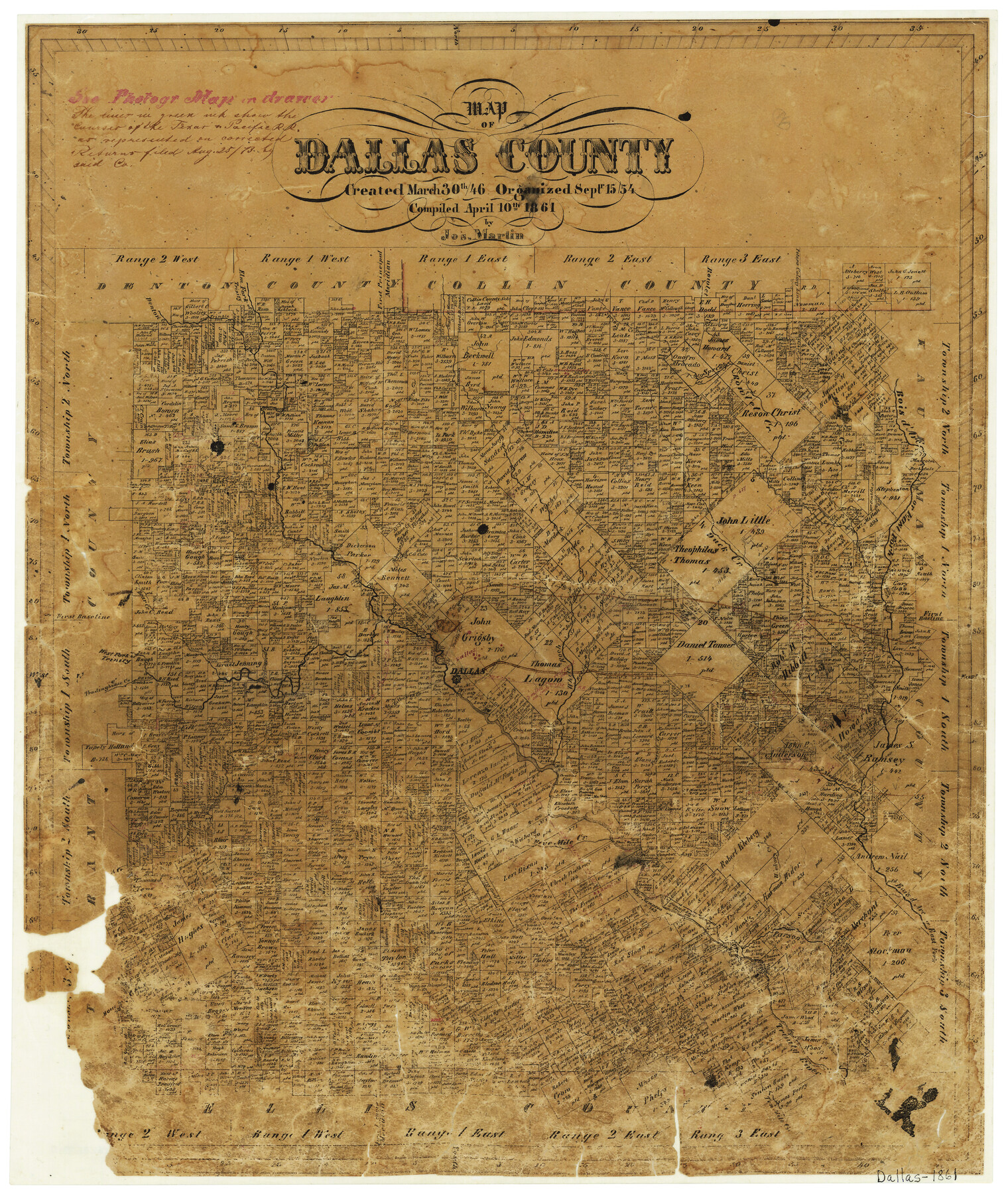
Map of Dallas County
-
Map/Doc
3467
-
Collection
General Map Collection
-
Object Dates
1861/4/10 (Creation Date)
-
People and Organizations
Texas General Land Office (Publisher)
Joseph Martin (Compiler)
-
Counties
Dallas
-
Subjects
County
-
Height x Width
23.5 x 20.0 inches
59.7 x 50.8 cm
-
Comments
Note on map: "Created March 30, 1846; organized September 15, 1854".
Railroads and towns added later to map. -
Features
Tradinghouse Creek
Delaware Creek
Dallas
Mill Creek
White Rock Creek
Redding Creek
Gilbert's Creek
Long Creek
Mesquite Creek
Prairie Creek
Bear Creek
Hickory Creek
Parson's Creek
Five Mile Creek
Ten Mile Creek
Miller
Hutchins
T&P
H&TC
Bois D'Arc Creek
Grapevine Creek
Elm Fork of Trinity River
Trinity River
Farmer's Creek
Larners Creek
Spring Creek
Rowlet Creek
Muddy Creek
Denton Creek
West Fork of Trinity River
North Branch of Trinity River
East Fork of Trinity River
Duck Creek
Ash Creek
Breckenridge
Browning Creek
Hackberry Creek
Part of: General Map Collection
Lynn County Sketch File 13

Print $18.00
- Digital $50.00
Lynn County Sketch File 13
1903
Size 10.6 x 8.1 inches
Map/Doc 30482
Hudspeth County Sketch File 19

Print $4.00
- Digital $50.00
Hudspeth County Sketch File 19
1901
Size 11.3 x 8.8 inches
Map/Doc 26962
Parker County Sketch File 11

Print $4.00
- Digital $50.00
Parker County Sketch File 11
1859
Size 12.8 x 8.1 inches
Map/Doc 33542
San Patricio County Rolled Sketch 46

Print $20.00
- Digital $50.00
San Patricio County Rolled Sketch 46
1983
Size 19.6 x 25.5 inches
Map/Doc 7730
Flight Mission No. BRE-4P, Frame 170, Nueces County

Print $20.00
- Digital $50.00
Flight Mission No. BRE-4P, Frame 170, Nueces County
1956
Size 18.5 x 22.6 inches
Map/Doc 86833
Sterling County Sketch File 25

Print $4.00
- Digital $50.00
Sterling County Sketch File 25
1892
Size 11.1 x 8.9 inches
Map/Doc 37192
Natural Heritage of Texas

Print $40.00
- Digital $50.00
Natural Heritage of Texas
1986
Size 54.3 x 56.0 inches
Map/Doc 10786
King County Working Sketch 6

Print $20.00
- Digital $50.00
King County Working Sketch 6
1944
Size 11.5 x 18.3 inches
Map/Doc 70170
United States Atlantic and Gulf Coasts Including Puerto Rico and the Virgin Islands

Print $40.00
- Digital $50.00
United States Atlantic and Gulf Coasts Including Puerto Rico and the Virgin Islands
1989
Size 20.6 x 60.3 inches
Map/Doc 73553
Midland County Rolled Sketch 14

Print $20.00
- Digital $50.00
Midland County Rolled Sketch 14
1996
Size 21.3 x 26.7 inches
Map/Doc 6769
Presidio County Working Sketch 124

Print $20.00
- Digital $50.00
Presidio County Working Sketch 124
1984
Size 30.8 x 24.3 inches
Map/Doc 71802
Taylor County Sketch File 14

Print $6.00
- Digital $50.00
Taylor County Sketch File 14
1881
Size 12.9 x 8.5 inches
Map/Doc 37802
You may also like
Rains County Rolled Sketch 2

Print $41.00
- Digital $50.00
Rains County Rolled Sketch 2
1958
Size 10.4 x 15.4 inches
Map/Doc 48829
Brazos River Entrance
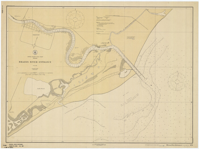
Print $20.00
- Digital $50.00
Brazos River Entrance
1925
Size 31.0 x 41.4 inches
Map/Doc 69974
Roberts County Boundary File 2

Print $12.00
- Digital $50.00
Roberts County Boundary File 2
Size 9.9 x 6.4 inches
Map/Doc 58333
Carta General de la República Mexicana Formada para el estudio de la configuracion y division interior de su territorio

Print $20.00
- Digital $50.00
Carta General de la República Mexicana Formada para el estudio de la configuracion y division interior de su territorio
Size 23.2 x 29.4 inches
Map/Doc 95823
Map of Orange County

Print $20.00
- Digital $50.00
Map of Orange County
1880
Size 15.2 x 19.2 inches
Map/Doc 3930
Jim Wells County Working Sketch 6

Print $20.00
- Digital $50.00
Jim Wells County Working Sketch 6
1943
Size 33.3 x 21.2 inches
Map/Doc 66604
Flight Mission No. DIX-7P, Frame 89, Aransas County

Print $20.00
- Digital $50.00
Flight Mission No. DIX-7P, Frame 89, Aransas County
1956
Size 18.7 x 22.4 inches
Map/Doc 83883
Ward County, Texas

Print $20.00
- Digital $50.00
Ward County, Texas
1888
Size 20.2 x 25.5 inches
Map/Doc 657
Presidio County Sketch File 49

Print $6.00
- Digital $50.00
Presidio County Sketch File 49
1919
Size 14.6 x 11.9 inches
Map/Doc 34584
Ward County Sketch File 12

Print $4.00
- Digital $50.00
Ward County Sketch File 12
Size 14.3 x 8.8 inches
Map/Doc 39638
[Anderson County]
![5051, [Anderson County], General Map Collection](https://historictexasmaps.com/wmedia_w700/maps/5051-GC.tif.jpg)
Print $20.00
- Digital $50.00
[Anderson County]
1848
Size 26.0 x 19.9 inches
Map/Doc 5051
Newton County Working Sketch 3

Print $20.00
- Digital $50.00
Newton County Working Sketch 3
1924
Size 18.2 x 20.6 inches
Map/Doc 71249