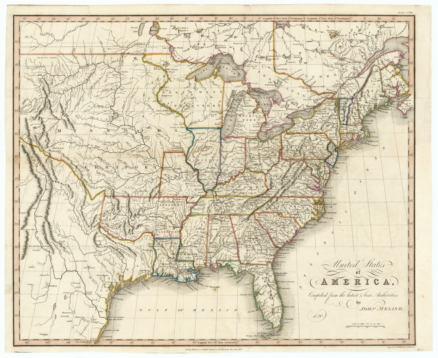
United States of America, compiled from the latest & best authorities by John Melish, 1820
-
Map/Doc
89220
-
Collection
General Map Collection
-
Object Dates
1820 (Creation Date)
-
People and Organizations
Mathew Carey & Son (Publisher)
John Melish (Author)
-
Subjects
United States
-
Height x Width
16.7 x 20.2 inches
42.4 x 51.3 cm
-
Comments
From C. V. Lasvoisne's "A Complete Genealogical, Historical, Chronological, and Geographical Atlas
-
URLs
https://medium.com/save-texas-history/united-states-of-america-compiled-from-the-latest-and-best-authorities-1820-by-john-melish-96480967153c#.yxdmwqxrv
Part of: General Map Collection
King County Working Sketch 18

Print $20.00
- Digital $50.00
King County Working Sketch 18
1994
Size 31.3 x 35.1 inches
Map/Doc 70182
Pecos County Rolled Sketch 110

Print $20.00
- Digital $50.00
Pecos County Rolled Sketch 110
Size 29.1 x 30.4 inches
Map/Doc 7255
Flight Mission No. DAG-21K, Frame 120, Matagorda County

Print $20.00
- Digital $50.00
Flight Mission No. DAG-21K, Frame 120, Matagorda County
1952
Size 18.5 x 22.3 inches
Map/Doc 86446
La Salle County Working Sketch 10

Print $20.00
- Digital $50.00
La Salle County Working Sketch 10
1928
Size 30.6 x 20.5 inches
Map/Doc 70311
Hutchinson County Working Sketch 5

Print $20.00
- Digital $50.00
Hutchinson County Working Sketch 5
1912
Size 16.0 x 11.4 inches
Map/Doc 66363
Wharton County Working Sketch 12

Print $20.00
- Digital $50.00
Wharton County Working Sketch 12
1970
Size 22.3 x 30.3 inches
Map/Doc 72476
Freestone County Rolled Sketch 11

Print $20.00
- Digital $50.00
Freestone County Rolled Sketch 11
1934
Size 17.9 x 34.1 inches
Map/Doc 5911
[Surveys in Cherokee County]
![251, [Surveys in Cherokee County], General Map Collection](https://historictexasmaps.com/wmedia_w700/maps/251.tif.jpg)
Print $2.00
- Digital $50.00
[Surveys in Cherokee County]
Size 8.0 x 5.6 inches
Map/Doc 251
Brooks County Sketch File 11

Print $14.00
- Digital $50.00
Brooks County Sketch File 11
Size 11.3 x 8.9 inches
Map/Doc 16573
Calhoun County NRC Article 33.136 Location Key Sheet

Print $20.00
- Digital $50.00
Calhoun County NRC Article 33.136 Location Key Sheet
1973
Size 27.0 x 23.0 inches
Map/Doc 87906
Brazos River, Brazos River Sheet 4

Print $6.00
- Digital $50.00
Brazos River, Brazos River Sheet 4
1926
Size 19.7 x 32.0 inches
Map/Doc 65297
United States - Gulf Coast - Galveston to Rio Grande

Print $20.00
- Digital $50.00
United States - Gulf Coast - Galveston to Rio Grande
Size 27.9 x 18.3 inches
Map/Doc 72742
You may also like
Township No. 2 South Range No. 21 West of the Indian Meridian

Print $20.00
- Digital $50.00
Township No. 2 South Range No. 21 West of the Indian Meridian
1875
Size 19.3 x 24.4 inches
Map/Doc 75177
Burnet County Rolled Sketch 3

Print $20.00
- Digital $50.00
Burnet County Rolled Sketch 3
Size 23.7 x 26.2 inches
Map/Doc 5355
[I. & G. N. Block 1, Secs. 65-75]
![90307, [I. & G. N. Block 1, Secs. 65-75], Twichell Survey Records](https://historictexasmaps.com/wmedia_w700/maps/90307-1.tif.jpg)
Print $20.00
- Digital $50.00
[I. & G. N. Block 1, Secs. 65-75]
1928
Size 22.0 x 18.0 inches
Map/Doc 90307
Bandera County Working Sketch 36

Print $20.00
- Digital $50.00
Bandera County Working Sketch 36
1966
Size 22.5 x 29.5 inches
Map/Doc 67632
Harris County Sketch File 3

Print $4.00
- Digital $50.00
Harris County Sketch File 3
Size 7.0 x 6.2 inches
Map/Doc 25334
Ochiltree County Sketch File 9

Print $14.00
- Digital $50.00
Ochiltree County Sketch File 9
1934
Size 11.1 x 8.8 inches
Map/Doc 33194
Borden County Working Sketch 15

Print $20.00
- Digital $50.00
Borden County Working Sketch 15
1984
Size 25.5 x 18.9 inches
Map/Doc 67475
PSL Field Notes for Blocks 53 and 55 in Culberson and Reeves Counties and Blocks 42, 52, and 54 in Culberson County

PSL Field Notes for Blocks 53 and 55 in Culberson and Reeves Counties and Blocks 42, 52, and 54 in Culberson County
Map/Doc 81673
Map of Kerr County

Print $20.00
- Digital $50.00
Map of Kerr County
1864
Size 14.8 x 17.9 inches
Map/Doc 3760
Flight Mission No. CLL-4N, Frame 37, Willacy County

Print $20.00
- Digital $50.00
Flight Mission No. CLL-4N, Frame 37, Willacy County
1954
Size 18.4 x 22.1 inches
Map/Doc 87110
Eastland County Working Sketch 8

Print $20.00
- Digital $50.00
Eastland County Working Sketch 8
1919
Size 13.5 x 11.1 inches
Map/Doc 68789
McMullen County Working Sketch 33

Print $20.00
- Digital $50.00
McMullen County Working Sketch 33
1959
Size 37.3 x 27.0 inches
Map/Doc 70734