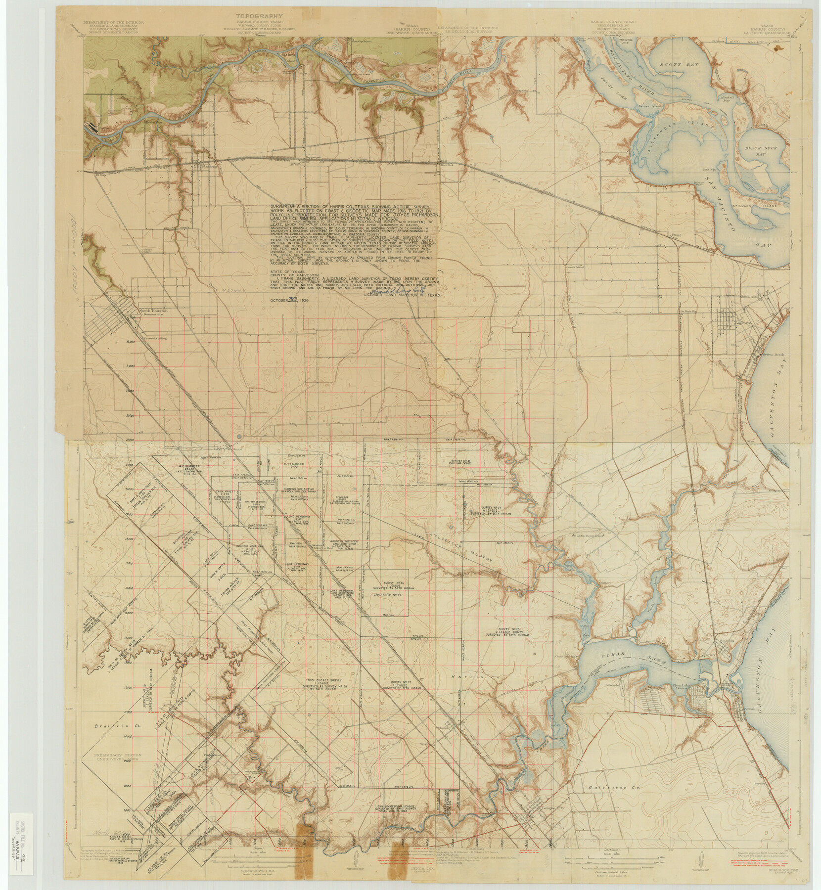
Harris County Sketch File 92
Seabrook, Tex.
-
Map/Doc
10483
-
Collection
General Map Collection
-
Object Dates
1932 (Creation Date)
1987/8/20 (File Date)
1916 (Survey Date)
1921 (Survey Date)
1824 (Survey Date)
1898 (Survey Date)
1938/10/30 (Creation Date)
1929 (Survey Date)
-
People and Organizations
Department of the Interior, U.S. Geological Survey (Publisher)
O.H. Nelson (Draftsman)
L.B. Roberts (Draftsman)
S.T. Penick (Draftsman)
Frank Daugherty (Surveyor/Engineer)
-
Counties
Harris Brazoria Chambers Galveston
-
Subjects
Surveying Sketch File
-
Height x Width
37.9 x 35.0 inches
96.3 x 88.9 cm
-
Medium
paper, print with manuscript additions
-
Scale
1:31660
-
Features
Fireworks Siding
Allen Road
Middle Bayou
Willow Springs Gully
Big Island Slough
Main Street
Little Cedar Bayou
La Porte
Sylvan Beach
Seabrook Road
Spring Gully
Red Bluff Road
Middle Bayou
GH&H
Galveston Road
GHE
Genoa Station
Genoa
Oaks
Galveston Bay
Red Bluff
Taylor Bayou
Boggy Bayou
La Porte Road
Olcott
Ellington Field
Horsepen Bayou
Old Middle Bayou School
Killkare
Pine Gully
Surf
Seabrook
Taylor Lake
Mud Lake
Wilson Avenue
Cow Bayou Gully
Clear Lake Inn
Clear Lake
Clear Lake Shores
Seabrook Bridge
Bayview
Glen Cove
Lakeside
Dredged Channel
Kemah
Jarbo Bayou
Bayview
Camp Meeting Gully
Webster
Clear Creek
Friendswood Bridge
Friendswood
Chigger Creek
U.S. Highway 75
League City
Conrad Bayou
Hunting Bayou
Houston Ship Channel
Greens Bayou
Buffalo Bayou
Penn City School
Penn City Ferry
San Jacinto Battlefield
Crystal Bay
Scott Bay
San Jacinto River
Santa Ana Bayou
Lynchburg and Cedar Bayou Road
Lyhchburg and Goose Creek Road
Peggy Lake
Barnes Island
Battle Grounds Road
Tuckers Bayou
Patrick Bayou
Boggy Bayou
Penn City Road
GH&SA
Deepwater
La Porte Road
Pooles Rest
Blakeley Road
Panner Branch of Buffalo Bayou
Clinton
Sims Bayou
Vince Bayou
El Buey
Pasadena
Colliers Corner
Red Road
Deer Park
Southern Pacific Railroad Company
Houston Road
Alexander Island
Brinson Point
Jennings Island
Spilmans Island
Hog Island
Black Duck Bay
San Jacinto Bay
Strang
East La Porte
La Porte Station
Lomax School
Berry Creek
South Houston
Part of: General Map Collection
Jefferson County Sketch File 39

Print $20.00
- Digital $50.00
Jefferson County Sketch File 39
Size 14.3 x 8.7 inches
Map/Doc 28218
Kimble County Sketch File 11

Print $40.00
- Digital $50.00
Kimble County Sketch File 11
1882
Size 20.5 x 10.2 inches
Map/Doc 28933
Henderson County Working Sketch 40

Print $20.00
- Digital $50.00
Henderson County Working Sketch 40
1982
Size 23.2 x 19.0 inches
Map/Doc 66173
San Patricio County Rolled Sketch 29B

Print $20.00
- Digital $50.00
San Patricio County Rolled Sketch 29B
1936
Size 25.8 x 31.0 inches
Map/Doc 7582
Archer County Working Sketch 5

Print $20.00
- Digital $50.00
Archer County Working Sketch 5
1919
Size 14.7 x 23.4 inches
Map/Doc 67145
Florida called by ye French Louisiana & c.

Print $20.00
- Digital $50.00
Florida called by ye French Louisiana & c.
1728
Size 9.6 x 14.3 inches
Map/Doc 94110
Panola County Working Sketch Graphic Index

Print $20.00
- Digital $50.00
Panola County Working Sketch Graphic Index
1947
Map/Doc 76660
Flight Mission No. DAG-18K, Frame 76, Matagorda County

Print $20.00
- Digital $50.00
Flight Mission No. DAG-18K, Frame 76, Matagorda County
1952
Size 17.5 x 22.1 inches
Map/Doc 86369
Amistad International Reservoir on Rio Grande 74

Print $20.00
- Digital $50.00
Amistad International Reservoir on Rio Grande 74
1949
Size 28.5 x 40.2 inches
Map/Doc 75501
Tarrant County Boundary File 2

Print $6.00
- Digital $50.00
Tarrant County Boundary File 2
Size 14.4 x 9.0 inches
Map/Doc 59111
Liberty County Working Sketch 6

Print $20.00
- Digital $50.00
Liberty County Working Sketch 6
1903
Size 17.2 x 19.5 inches
Map/Doc 70465
Live Oak County Boundary File 60a

Print $18.00
- Digital $50.00
Live Oak County Boundary File 60a
Size 12.7 x 8.4 inches
Map/Doc 56407
You may also like
Edwards County Working Sketch 107

Print $40.00
- Digital $50.00
Edwards County Working Sketch 107
1972
Size 54.5 x 38.8 inches
Map/Doc 68983
Sketch of the country between the Rio Bravo del Norte and the Luna Madre as high as Monterey copied from the map found among the papers of Genl. Arista

Print $20.00
- Digital $50.00
Sketch of the country between the Rio Bravo del Norte and the Luna Madre as high as Monterey copied from the map found among the papers of Genl. Arista
1846
Size 18.2 x 24.9 inches
Map/Doc 73049
Montgomery County Working Sketch 56

Print $20.00
- Digital $50.00
Montgomery County Working Sketch 56
1961
Size 21.2 x 24.0 inches
Map/Doc 71163
Deaf Smith County Sketch File 8

Print $20.00
- Digital $50.00
Deaf Smith County Sketch File 8
1988
Size 24.3 x 32.9 inches
Map/Doc 11304
Lampasas County Boundary File 16

Print $14.00
- Digital $50.00
Lampasas County Boundary File 16
Size 8.9 x 8.2 inches
Map/Doc 56216
Kerr County Working Sketch 4

Print $20.00
- Digital $50.00
Kerr County Working Sketch 4
1946
Size 37.6 x 26.2 inches
Map/Doc 70035
Schleicher County Sketch File 6

Print $4.00
- Digital $50.00
Schleicher County Sketch File 6
Size 8.1 x 8.5 inches
Map/Doc 36472
Duval County Working Sketch 18

Print $20.00
- Digital $50.00
Duval County Working Sketch 18
1939
Size 23.5 x 19.6 inches
Map/Doc 68731
[H. & T. C. 47, Sections 57- 61] / [Blocks 4 and 6]
![91417, [H. & T. C. 47, Sections 57- 61] / [Blocks 4 and 6], Twichell Survey Records](https://historictexasmaps.com/wmedia_w700/maps/91417-1.tif.jpg)
Print $20.00
- Digital $50.00
[H. & T. C. 47, Sections 57- 61] / [Blocks 4 and 6]
Size 25.9 x 19.5 inches
Map/Doc 91417

Navarro County Working Sketch 1b

Print $20.00
- Digital $50.00
Navarro County Working Sketch 1b
Size 32.5 x 44.6 inches
Map/Doc 71230
Topographical Map of the Rio Grande, Sheet No. 15

Print $20.00
- Digital $50.00
Topographical Map of the Rio Grande, Sheet No. 15
1912
Map/Doc 89539