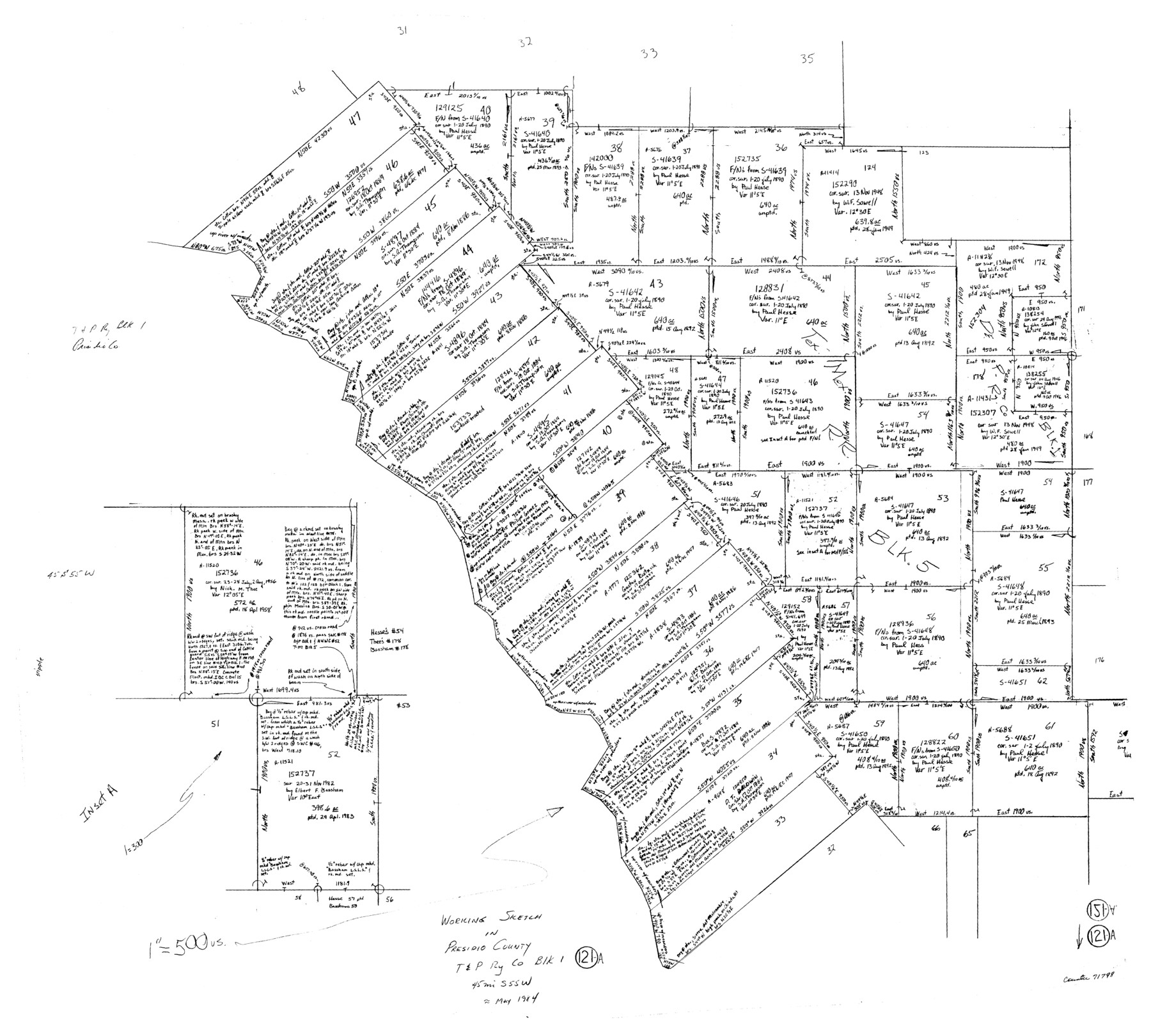
Presidio County Working Sketch 121a
-
Map/Doc
71798
-
Collection
General Map Collection
-
Object Dates
5/1984 (Creation Date)
-
Counties
Presidio
-
Subjects
Surveying Working Sketch
-
Height x Width
34.2 x 38.0 inches
86.9 x 96.5 cm
-
Scale
1" = 500 varas
Part of: General Map Collection
Burnet County Sketch File 7

Print $6.00
- Digital $50.00
Burnet County Sketch File 7
1854
Size 7.1 x 8.1 inches
Map/Doc 16686
Tom Green County Working Sketch 3

Print $20.00
- Digital $50.00
Tom Green County Working Sketch 3
1933
Size 47.5 x 40.2 inches
Map/Doc 69372
Denton County Working Sketch 20

Print $20.00
- Digital $50.00
Denton County Working Sketch 20
1978
Size 31.6 x 33.2 inches
Map/Doc 68625
Concho County Sketch File 32

Print $20.00
- Digital $50.00
Concho County Sketch File 32
Size 29.6 x 26.7 inches
Map/Doc 11157
Palo Pinto County Rolled Sketch 5

Print $40.00
- Digital $50.00
Palo Pinto County Rolled Sketch 5
1917
Size 53.8 x 35.8 inches
Map/Doc 76022
Bastrop County Sketch File 11

Print $52.00
- Digital $50.00
Bastrop County Sketch File 11
Size 11.2 x 8.7 inches
Map/Doc 14058
Harris County Sketch File 78

Print $32.00
- Digital $50.00
Harris County Sketch File 78
1955
Size 8.7 x 9.0 inches
Map/Doc 25549
Harris County Historic Topographic 18 1/2

Print $20.00
- Digital $50.00
Harris County Historic Topographic 18 1/2
1916
Size 29.3 x 13.7 inches
Map/Doc 65829

Limestone County Working Sketch 18

Print $20.00
- Digital $50.00
Limestone County Working Sketch 18
1962
Size 45.5 x 38.7 inches
Map/Doc 70568
Hopkins County Working Sketch 3

Print $20.00
- Digital $50.00
Hopkins County Working Sketch 3
1955
Size 24.2 x 20.0 inches
Map/Doc 66228
Flight Mission No. DQO-2K, Frame 165, Galveston County

Print $20.00
- Digital $50.00
Flight Mission No. DQO-2K, Frame 165, Galveston County
1952
Size 18.9 x 22.4 inches
Map/Doc 85054
You may also like
[Pencil Sketch of a portion of Block D-8]
![91872, [Pencil Sketch of a portion of Block D-8], Twichell Survey Records](https://historictexasmaps.com/wmedia_w700/maps/91872-1.tif.jpg)
Print $2.00
- Digital $50.00
[Pencil Sketch of a portion of Block D-8]
1937
Size 14.5 x 9.1 inches
Map/Doc 91872
General Highway Map, Atascosa County, Texas

Print $20.00
General Highway Map, Atascosa County, Texas
1961
Size 18.3 x 24.9 inches
Map/Doc 79356
El Paso County Sketch File 17

Print $20.00
- Digital $50.00
El Paso County Sketch File 17
1885
Size 20.1 x 30.9 inches
Map/Doc 11453
Flight Mission No. CRC-3R, Frame 39, Chambers County

Print $20.00
- Digital $50.00
Flight Mission No. CRC-3R, Frame 39, Chambers County
1956
Size 18.6 x 22.4 inches
Map/Doc 84812
Morris County Rolled Sketch 2A

Print $20.00
- Digital $50.00
Morris County Rolled Sketch 2A
Size 36.2 x 19.3 inches
Map/Doc 10282
[Blocks M-22 and M-25 and vicinity]
![91138, [Blocks M-22 and M-25 and vicinity], Twichell Survey Records](https://historictexasmaps.com/wmedia_w700/maps/91138-1.tif.jpg)
Print $20.00
- Digital $50.00
[Blocks M-22 and M-25 and vicinity]
Size 18.7 x 16.6 inches
Map/Doc 91138
Map of Archer County

Print $20.00
- Digital $50.00
Map of Archer County
1886
Size 24.4 x 20.5 inches
Map/Doc 3240
Gaines County

Print $40.00
- Digital $50.00
Gaines County
1901
Size 41.3 x 57.2 inches
Map/Doc 16833
Val Verde County Boundary File 1

Print $6.00
- Digital $50.00
Val Verde County Boundary File 1
Size 14.3 x 8.7 inches
Map/Doc 59572
Grayson County Sketch File 25

Print $6.00
- Digital $50.00
Grayson County Sketch File 25
Size 8.4 x 7.1 inches
Map/Doc 24507
Knox County Working Sketch 1

Print $20.00
- Digital $50.00
Knox County Working Sketch 1
1899
Size 32.7 x 25.4 inches
Map/Doc 70243
Comal County Working Sketch 14

Print $40.00
- Digital $50.00
Comal County Working Sketch 14
1992
Size 25.4 x 49.9 inches
Map/Doc 68180